Introduction
For decades following the processual revolution, regional settlement pattern studies routinely relied on George Kingsley Zipf’s Rank-size rule to infer the political integration, centralization, or balkanization of ancient polities. Yet throughout the 1970s and 1980s, the archaeological application of this principle remained hampered by qualitative heuristics-principally the visual inspection of log-log regression slopes-and an absence of rigorous statistical validation. Beginning with early graduate research at Arizona State University in 1991 and progressing across three decades of computational development and empirical field applications in the Southern Levant, I attempted to overhaul this analytical framework. By pairing Monte Carlo significance testing with Kolmogorov-Smirnov goodness-of-fit statistics, spatial K-means clustering, and public-domain software architecture, this trajectory replaced subjective curve-reading with an inferential diagnostic toolset capable of distinguishing genuine cultural behavior from systemic sampling error.
This website provides a chronological exploration of 18 years of work on settlement archaeology in the Near East. It is presented chronologically, but organized around three central research themes:
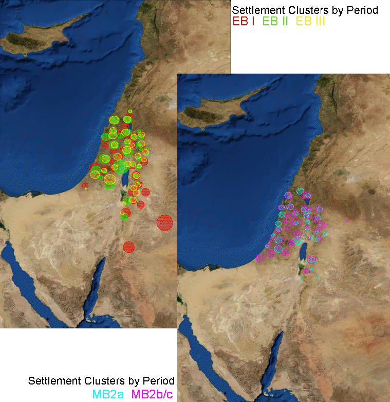
- Technical Development of Rank-Size Methods
- Replaced subjective visual curve-reading with inferential Monte Carlo simulation engines.
- Showed that if the largest site in a settlement system is found, surveys should recover 85% of sites to avoid sampling errors.
- Fixed the "lower limb problem" by implementing a truncation function to eliminate small sites.
- Allowed Ziph's q to be calculated or set
- Empirical Application and Textual Validation
- Applied cluster modeling across the southern Levant from the Chalcolithic to the Late Bronze Age.
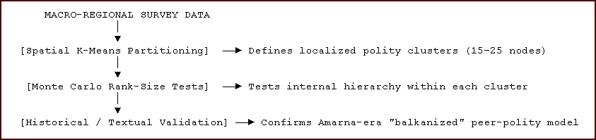
- Paired spatial K-means clustering with within-cluster Rank-size simulations to map 24 distinct polities.
- Provided independent archaeological ground-testing for polities described in the ancient Amarna Letters.
- Academic Citations and Practical Utility
- Tracked the real-world usage of these methodologies through verified academic citation indices.
- Documented over 300 citations for the 1995 American Antiquity paper on alternative urbanization trajectories.
- Formed the basis for macro-regional spatial databases including JADIS and DAAHL.
The Methodological Problem: The Limits of Visual Rank-Size Heuristics
Archaeological interpretations of settlement systems make use of the Rank-size rule and deviations from it to either predict or interpret human behavior. Numerous explanations for deviations from a lognormal distribution of site sizes have been advanced, ranging from low levels of system integration to core and periphery settlement patterns. Many different explanations have been advanced for the same Rank-size distributions. When evaluating these explanations, it is useful to examine the problem from the standpoint of a known site universe that corresponds to the Rank-size rule.
The Rank-size rule, as normally applied in archaeology (e.g. Crumley 1976; Johnson 1977, 1980), is expressed as: Sn = S1 / n, that is, the size of any nth rank place is found by dividing the size of the largest place by n (meaning that the rank of a given site times its size equals the size of the largest site. When plotted on logarithmic axes with the exponent q = 1, a fully integrated system approximates a linear log-normal distribution with a slope of −1.0.
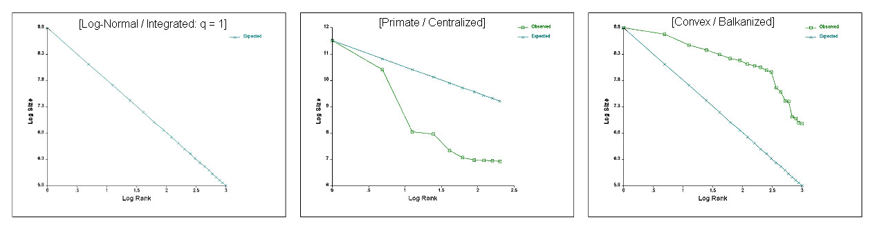
In archaeological practice, departures from this distribution were traditionally classified into two structural types:
- Primate Distributions: Characterized by an exceptionally large primary center relative to lower-tier settlements, theoretically indicative of core-periphery exploitation, colonial dominance, or high political centralization.
- Convex Distributions: Characterized by multiple settlements of comparable size at the upper end of the distribution, interpreted as poorly integrated, autonomous, or "balkanized" regional sub-systems.
Despite the theoretical utility of these constructs, early archaeological applications suffered from two fundamental statistical flaws:
- The Absence of Significance Metrics: Standard Kolmogorov-Smirnov (KS) critical value tables were developed for continuous statistical distributions, not for discrete, stepped order statistics derived from regional settlement inventories. Archaeologists frequently interpreted minor departures from log-normality as evidence of state centralization without establishing whether those deviations exceeded random expectation.
- The Sensitivity to Incomplete Recovery (The "Lower Limb Problem"): Regional surveys rarely identify 100% of ancient settlement universes. Small agricultural hamlets, field huts, and seasonal campsites are disproportionately obscured by modern land use, alluvium, or survey intensity boundaries. This systemic loss introduces severe artificial drop-offs in the lower tier of the distribution, distorting the empirical slope and manufacturing false structural interpretations.
The 1991 Term Paper (ranksize.bas)
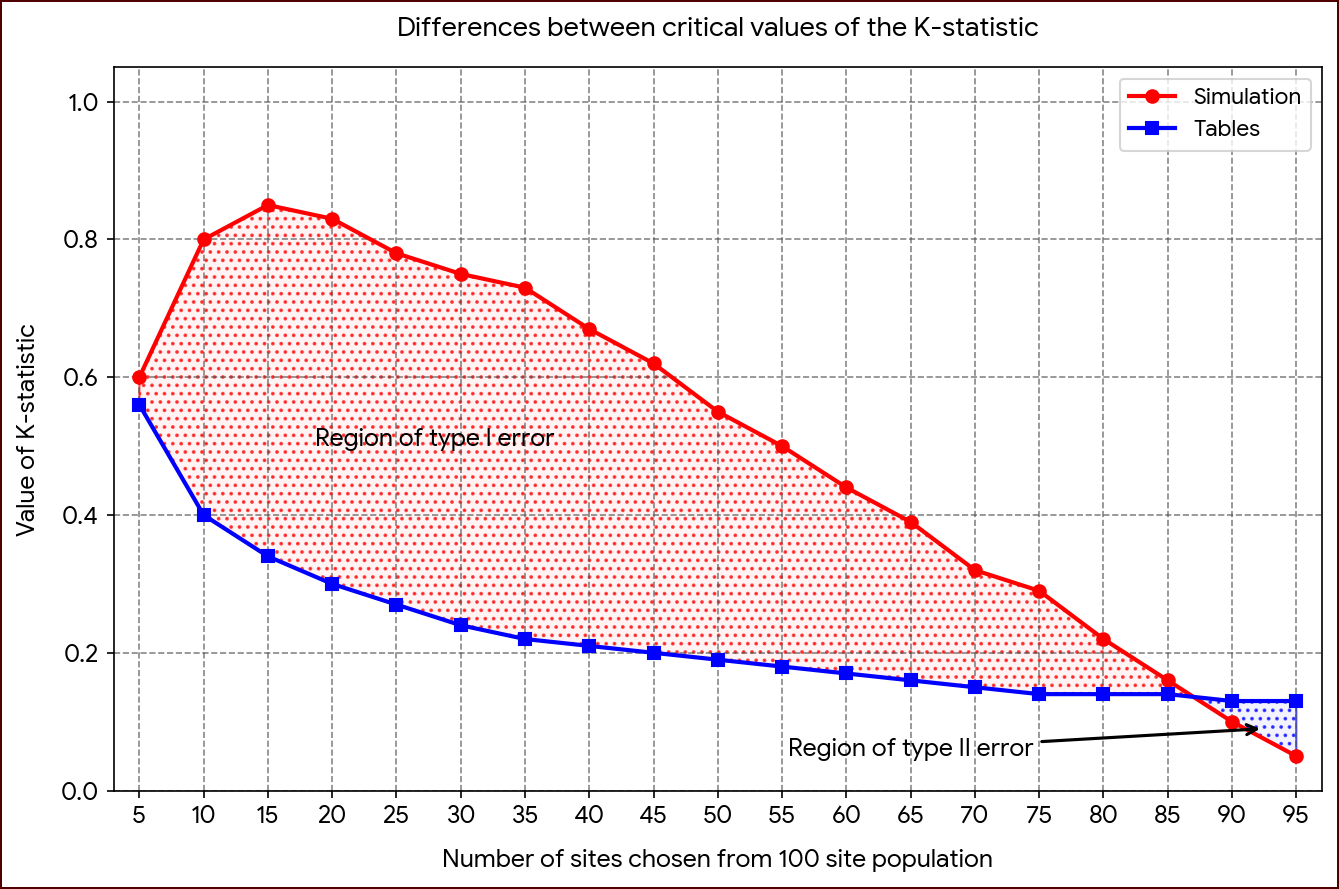
In a 1991 graduate seminar paper at Arizona State University ("A Monte-Carlo Simulation Study of the Rank-size Rule in Settlement Archaeology"), Savage constructed a simulation engine written in Turbo BASIC. Executing more than 35,000 discrete iterations across controlled site universes (N = 50, 100, 200), the algorithm generated custom Kolmogorov-Smirnov confidence boundaries specifically calibrated for settlement data. To resolve the statistical invalidity of continuous KS tables when applied to stepped Rank-size data, the research developed custom simulation algorithms designed to establish empirical confidence intervals around theoretical log-normal distributions. The Monte-Carlo simulation program evaluated the effects of sample proportions, the number of sites in a given population, and the effects of finding or not finding the largest site in a region. Results indicate that eighty-five percent of the sites must be found, and the largest site known, to consistently achieve accurate results. A confidence interval method of evaluating site distributions allowed some of the problems with sampling error to be overcome.
The primary contribution of this initial study was demonstrating the mathematical vulnerability of Rank-size curves to survey sampling rates:
- The Primacy Artifact: The simulation demonstrated that if a survey correctly identifies the regional primate center but recovers less than 80–85% of the lower-tier settlement universe, the resulting Rank-size plot is mathematically guaranteed to exhibit a false primate profile.
- The 85% Threshold: To reliably differentiate a culturally significant primate or convex pattern from an artifact of archaeological recovery, regional surveys must achieve a minimum recovery rate of approximately 85% of the total site universe, while reliably capturing the absolute maximum settlement size.
Prior to this work, archaeologists routinely applied Zipf’s Rank-size rule-plotting settlement sizes against their rank on logarithmic axes-to infer political integration, economic pooling, or primate/convex settlement hierarchies. However, these interpretations often suffered from qualitative bias: researchers simply visually inspected the slope and declared a pattern "convex" (suggesting poorly integrated systems) or "primate" (suggesting centralized dominance) without evaluating whether the deviation from a log-normal distribution was statistically significant. The initial paper introduced a Monte Carlo simulation method specifically tailored for archaeological Rank-size distributions. This computational tool generated confidence intervals around expected log-normal curves, enabling archaeologists to statistically test whether an observed settlement system deviated significantly from random expectation or represented genuine socio-political structures.
The results of the Monte-Carlo simulation study presented in the first paper were startling. Unless eighty five percent of the original sites, and the largest site in the region are known, the a Rank-size plotting results are almost certainly attributable to sampling errors. If the largest site is found, but less than eighty five percent of the site population is recovered, the results will indicate a primate situation. Thus, many projects that were conducted in the past may have inferred primate conditions and attributed that primacy to several cultural factors, but the results are probably within the realm of sampling error, be it caused by survey design or site attrition.
The 1992 Ruppé Prize Expansion
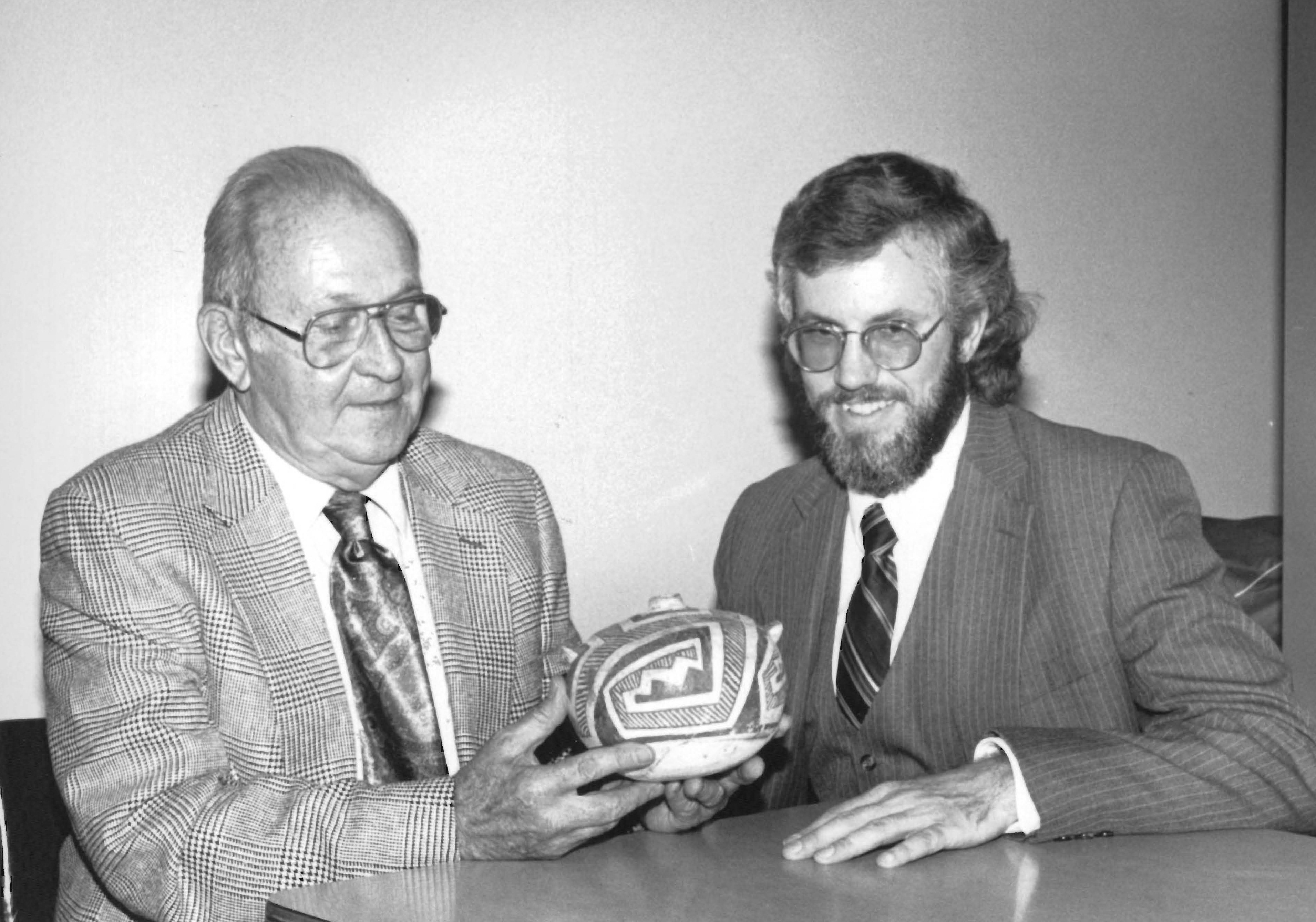
Ruppé prize for the best graduate paper in archaeology.
Expanded into an award-winning monograph for the inaugural Reynold J. Ruppé Prize in Archaeology ("A Monte-Carlo Simulation Study of the Rank-Size Rule in Settlement Archaeology: With Application to the Chalcolithic and Bronze Ages of the Southern Levant"), the method was rewritten in Turbo Pascal 6.0 as a compiled executable (RankSize).
While the 1991 paper was a purely predictive, controlled experiment using an artificial, simulated site universe, the 1992 Ruppe Prize-winning version transitioned the code from a theoretical exercise into an empirical analytical tool:
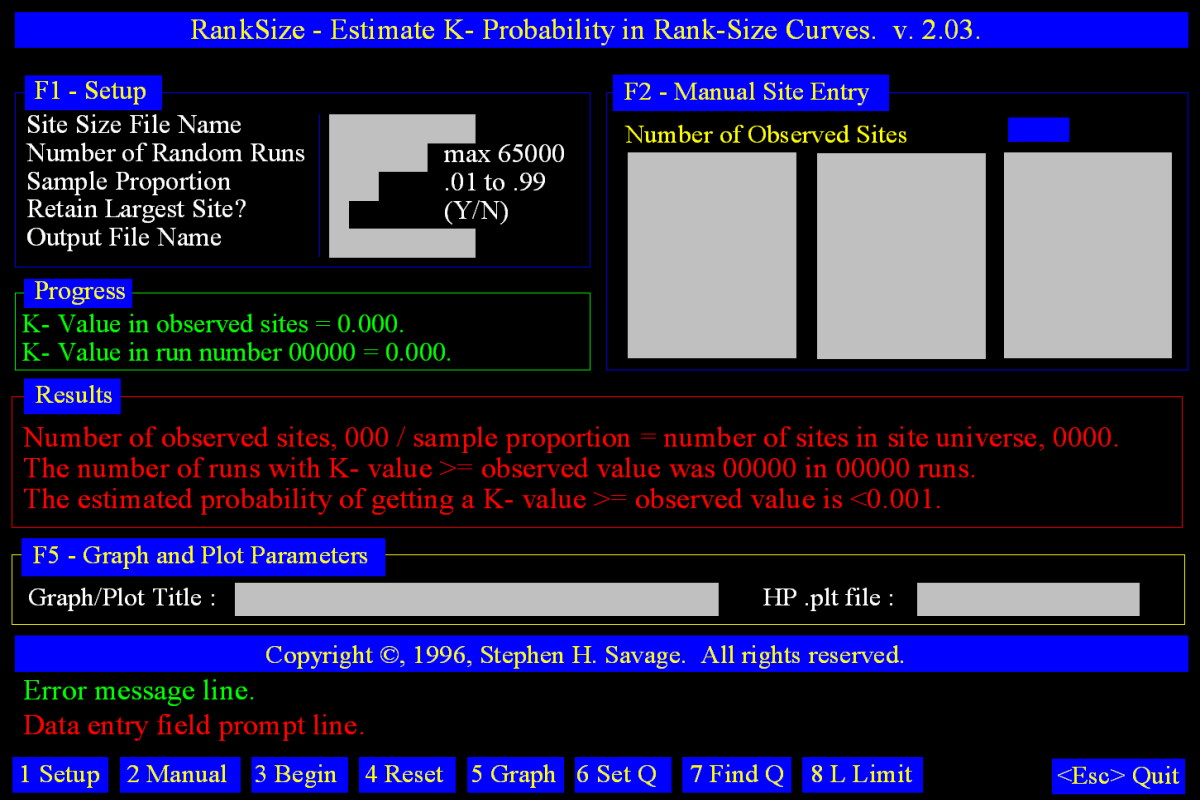
- Application to Regional Trajectories: The Pascal engine was run against multi-period survey inventories from the southern Levant (integrating data from Gophna, Portugali, and contemporary regional surveys), establishing baseline profiles across the Chalcolithic, Early Bronze Age (EBA), and Middle Bronze Age (MBA).
- The Primo-Convex Signature: The paper formalized the intermediate primo-convex profile-a distribution exhibiting a dominant, primate primary center paired with a convex, stepped distribution across secondary and tertiary settlements. It demonstrated that this pattern emerges when an imperial or volatile administrative capital is artificially superimposed over a baseline of resilient, self-sustaining rural networks.
- Predictive Performance Regression: The manuscript introduced a spatial linear regression to calculate the statistical predictability of simulation outcomes, defining Optimal Performance (OPerf): OPerf = −153 + (14.4 · LSite) + (9.26 · SProp), where LSite represents the logarithmic magnitude of the largest site and SProp represents the proportion of the recovered site universe. This equation accounted for 98% of the statistical variance across simulation runs, formally establishing that apparent departures from log-normality are heavily conditioned by the recovery proportion of the sample.
- Solving Zipf’s Complete Equation (Calculating q): The initial graduate paper critiqued the standard archaeological practice of assuming Zipf’s exponent q always equaled exactly 1. The Turbo Pascal edition unlocked the ability to empirically calculate the true value of q using the least-squares regression method across log-log plot distributions. Instead of forcing data into an idealized log-normal line, this capability allowed archaeologists to calculate whether the force of urban unification or rural diversification dominated an ancient society. It provided a direct mathematical metric to evaluate the actual degree of state centralization or systemic balkanization across different eras. And the program let the user set a value for q to alter the slope of the expected Rank-size distribution.
- Defeating the "Lower Limb Problem": A universal frustration in regional surface surveys is that very small archaeological sites (hamlets, field huts, and seasonal campsites) skew Rank-size graphs. Because these tiny spaces drop off rapidly or are under-represented due to survey visibility, they cause the bottom of a plot line to curve aggressively downward. The Turbo Pascal RankSize engine introduced diagnostic algorithms specifically built to handle this lower limb distortion. It allowed users to run Monte Carlo simulations on truncated datasets, isolating and filtering out the minor settlement noise. This functionality ensured that missing or hard-to-detect small hamlets would not artificially corrupt the mathematical calculations of upper-tier political complexity.
- Multi-Plot Diachronic Overlays: The new interface enabled researchers to overlay multiple archaeological phases and geographic zones simultaneously, facilitating direct comparative analysis of regional restructuring over time.
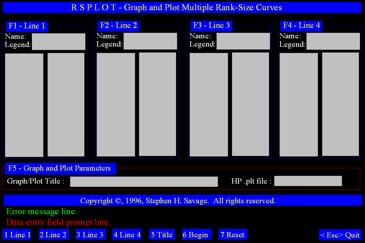
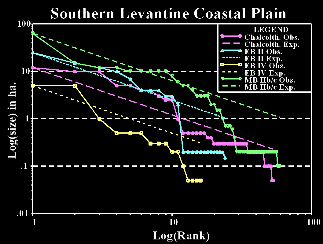
The theoretical and computational architecture developed across these two papers was subsequently published in the Journal of Archaeological Science (Savage 1997), providing the international discipline with an accessible, standardized method for evaluating departures from log-normality.
Winning the Ruppe Prize for this expanded methodology served as a catalyst for further work in Near Eastern spatial archaeology:
- Methodological Validation: The academic recognition solidified a trajectory in quantitative methodology--directly informing later postdoctoral research on the Early Bronze Age city-states of the Southern Levant, where these methods were used to demonstrate that Levantine urban networks were localized and fragmented rather than monolithic empires.
- Evolution into Geospatial Infrastructure: The success of coding the analytical software (ranksize.bas) set a pattern--instead of relying solely on commercial software, I developed custom digital architecture where needed, ultimately leading to major spatial humanities projects like the Digital Archaeological Atlas of the Holy Land (DAAHL) and TerraWatchers.
By showing that the traditional Kolmogorov-Smirnov (KS) table thresholds were explicitly mathematically invalid for step-wise Rank-size lines, the 1992 work handed a warning--and a solution--to global settlement archaeology:
- Beyond the Visual "Eyeball" Test: Before this paper, archaeologists routinely published log-log settlement plots and subjectively claimed a culture was integrated or decentralized based on looking at line slopes. The paper provided an empirical path forward: researchers can compute exact maximum absolute deviations and compare them to custom Monte Carlo confidence tables to ensure they are not reading meaning into simple noise.
- The Need for Full-Coverage Survey: The paper showed that if you recover less than 85% of a regional settlement pattern, your data is mathematically guaranteed to generate a false primate or convex profile purely from sampling error. Global scholars (such as those mapping Mesoamerican states, Roman empires, or Mediterranean fields) frequently cite these findings to stress to funding bodies that full-coverage, high-intensity visual surveys are mandatory to avoid analytical/interpretive error.
Empirical Application and Regional Realities: The Levant (1995–2003)
The utility of any computational method relies on its capacity to clarify ambiguous or contested archaeological records. In collaboration with Steven E. Falconer, Savage deployed these Monte Carlo significance models to evaluate long-standing questions surrounding urbanization, state formation, and rural resilience in the Southern Levant.
Decoupling Urban Collapse from Rural Continuity (Falconer and Savage 1995)
In "Heartlands and Hinterlands: Alternative Trajectories of Early Urbanization in Mesopotamia and the Southern Levant." American Antiquity 60(1): 37-58, the simulation methodology was applied to the settlement dynamics of two regions. Comparative Rank-size analyses revealed highly variable courses of urbanization in ancient Mesopotamia and the southern Levant during the fourth through early second millennia B.C. While traditional Rank-size methods do not consider the efects of archaeological sampling, the authors used a revised approach based on the 1992 Monte Carlo simulation program, which incorporated site-recovery rates and demonstrates the advantages of "full-coverage" survey. The paper highlights the rapid development of urban primacy in southern Mesopotamia's heartland fAdams 1981) and the more static rural integration of the Diyala hinterland (Adams 1965). In contrast, Bronze Age urbanization in the southern Levant describes a mosaic of urban and rural systems following independent trajectories. The paper called for greater attention to small sites, which often define the shape of Rank-size distributions, and showed that modest cases of urbanizatlon in terms of structure, rather than simply of reduced scale, and avoided a tendency to categorize such cases as derivatlve.
For decades, early cities in the Southern Levant were treated as poorly executed imitations of the massive, highly centralized mega-cities found in southern Mesopotamia. Utilizing Savage's simulation frameworks to correct for uneven surface collection across regional datasets, the authors demonstrated that the Southern Levant followed a fundamentally different trajectory. Instead of developing rigid, vertical, state-level command economies, the Levant featured a "heterarchical" mosaic of towns and rural village networks. This paper has been cited over 300 times, shifting the field away from Eurocentric and Mesopotamian-centric definitions of civilization toward localized models of social complexity.
Key Impact and Conceptual Contributions:
- Rejection of "Core-Periphery" Bias: Historically, Levantine settlements were often dismissed as peripheral, "watered-down" versions of massive Mesopotamian cities. Savage and Falconer argued that the Southern Levant possessed a unique, locally adapted form of urbanization defined by a mosaic of town-village networks rather than mega-cities.
- Statistical and Methodological Innovation: The authors pioneered the use of rigorous, simulated sampling (like Monte Carlo simulations) to ensure that archaeological surveys account for uneven surface coverage and the inherent biases of missing small, rural sites.
- Heterarchical Organization: The paper popularized the idea that societies could be politically and economically integrated "horizontally," allowing for resilient regional development without rigid, state-level vertical control.
How Researchers Use the Paper:
- Studies of the "Canaanite City": Researchers such as archaeologists Alexander Fantalkin, Oren Tal, and Aren Maeve have leveraged the Heartlands and Hinterlands framework to redefine Canaanite urbanization. They utilize the paper’s principles to argue that the Middle Bronze Age and Iron Age city-states in the Levant functioned as localized "domesticating apparatuses"--highly tied to their rural hinterlands--rather than mere imitations of Mesopotamian or Egyptian empires.
- Spatial Analysis and Settlement Scaling: Urban archaeologists and geographers (e.g., Fulminante, Blanton, Fargher) have widely adopted the paper's statistical approach to settlement hierarchy and Rank-size distribution. The paper's models of primate vs. convex (primate vs. highly centralized) settlement distribution allow scholars to compare ancient Levantine urbanization with global models of state-level societies, ranging from Highland Mesoamerica to the Etruscan city-states of Italy.
- Comparative Settlement and Territoriality: Specialists in the Near Eastern Bronze Age rely on Falconer and Savage's framework to differentiate localized regional integration from massive urban cores. Scholars like Timothy Harrison apply this paradigm to understand how the diverse ecology of the Mediterranean and Jordan River Valley supported distinct agricultural intensification that necessitated flexible, independent economic and political networks.
Master Citation Index: Falconer & Savage (1995) Derived from Google Scholar
Mapping for all bibliography references citing Falconer, Steven E. & Stephen H. Savage (1995) Heartlands and Hinterlands: Alternative Trajectories of Early Urbanization in Mesopotamia and the Southern Levant. American Antiquity 60(1): 37-58.
| Author(s) & Year | Publication | Summary | Utilization |
|---|---|---|---|
| Adams, Donovan M. (2020) | Community Development and Culture Negotiation during the Early Bronze Age in Western Anatolia. Ph.D. dissertation, Department of Anthropology, University of Nevada, Reno. | Investigates community identity and negotiation in EBA Western Anatolia. | Compares regional decentralized models to evaluate local landscape socio-political strategies. |
| Agosto, Mara Beatriz (2025) | The Concept of Landscape in Processual Archaeology and its Conceptual Tools: An Overview. Espacio Tiempo y Forma. Serie I, Prehistoria y Arqueología 18:83–111. | Evaluates the history of 'landscape' and its analytical tools in archaeology. | Cites it as a foundational example of spatial analysis and settlement hierarchy, including Rank-size analysis. |
| Ahn, Yoonee (2020) | Re-Evaluating the Intermediate Bronze Age in the Southern Levant. Ph.D. dissertation, School of Theology, Southwestern Baptist Theological Seminary, Fort Worth. | Re-evaluates socio-political transitions and demographic shifts in the Southern Levantine Intermediate Bronze Age. | Employs their 'rural complexity' framework to interpret rural adaptation following urban collapse. |
| Alexandrovsky, Daniela (2021) | Early Bronze Age I Tabular Scraper Distribution: An Agent-Based Modeling Approach. Master's thesis, Department of Archaeology, University of Haifa, Haifa. | Uses agent-based modeling for EBA I tabular scraper exchange in the Levant. | Grounds simulations using their regional spatial data and EBA settlement density patterns. |
| Allen, Eowyn, Steven E. Falconer, Hessam Sarjoughian, Michael C. Barton, and Patricia L. Fall (2006) | Modeling of Agropastoral Human Activities Using Agent-Based Simulation. Paper presented at the 70th Annual Meeting of the Society for American Archaeology, San Juan, Puerto Rico. | Presents an agent-based simulation of agropastoral activities in the Levant. | Directly operationalizes their rural resilience concepts and spatial data into simulation models. |
| Allentuck, Adam (2013) | Human-Livestock Relations in the Early Bronze Age of the Southern Levant. Ph.D. dissertation, Department of Anthropology, University of Toronto, Toronto. | Evaluates zooarchaeological data on human-animal relations in the Southern Levant. | Uses their framework to explain agrarian village support for non-state urbanism. |
| Altaweel, Mark (2013) | The Application of an Entropy Maximising Model for Understanding the Rise of Urbanism. BAR International Series 2569. Archaeopress, Oxford. | Uses entropy-maximizing models to study Near Eastern urban emergence. | Evaluates their Rank-size trajectories against computational models to assess central place variants. |
| Altaweel, Mark (2015) | Settlement Dynamics and Hierarchy from Agent Decision-Making: A Method Derived from Entropy Maximization. Journal of Archaeological Method and Theory 22(4):1122–1150. | Develops entropy methods for modeling settlement hierarchies and decisions. | Critiques and refines the Rank-size analysis methods applied by the authors. |
| Altaweel, Mark, & Palmisano, Alessio (2015) | Evaluating Settlement Structures in the Ancient Near East Using Spatial Interaction Entropy Maximization. Structure and Dynamics 8(1):1–33. | Applies entropy modeling to map regional connectivity in the ancient Near East. | Validates spatial models using their empirical Levantine vs. Mesopotamian data. |
| Andreou, Georgia M. (2019) | Socioeconomics of Agrarian Production: Considering Rural Cooperatives in the Archaeology of the Eastern Mediterranean Through the Lens of 2nd Millennium BCE Cyprus. World Archaeology 51(2):291–310. | Explores the socioeconomics of Bronze Age Cypriot agriculture through theories of rural cooperatives. | Adapts their 'rural complexity' framework to demonstrate how decentralized agricultural villages manage production independently of elite state control. |
| Antonites, Alexander (2012) | Political and Economic Interactions in the Hinterland of the Mapungubwe Polity, c. AD 1200-1300, South Africa. Ph.D. dissertation, Department of Anthropology, Yale University, New Haven. | Investigates political and economic dynamics in the hinterlands of the Mapungubwe state in South Africa. | Utilizes their comparative model to analyze hinterland-center dynamics and evaluate how local autonomy persists far from regional centers. |
| Arikan, Bulent (2010) | Reorganization and Risk: Environmental Change and Tribal Land Use in Marginal Landscapes of Southern Jordan. Ph.D. dissertation, School of Human Evolution and Social Change, Arizona State University, Tempe. | Examines tribal land use, environmental change, and socio-political risk management in southern Jordan. | Integrates their spatial and demographic data on the Southern Levant to contextualize long-term rural stability and pastoral resilience. |
| Arnold, Philip J., III (2008) | Risky Business: Archaeology by Robert's Rules. Journal of Anthropological Research 64(3):425–435. | Discusses methodological and theoretical challenges ('Robert's Rules') within archaeological research practices. | References their article to comment on peer evaluation and the broader methodological debates surrounding regional Rank-size analysis. |
| Babcock, Lindsay E., & Arnold, Elizabeth R. (2014) | Identifying Merchants in the Early Bronze Age City of Tell es-Safi: Isotopic Analysis of a Sacrificial Ass. Paper presented at the 79th Annual Meeting of the Society for American Archaeology, Austin, Texas. | Uses isotopic analysis on a sacrificed donkey to trace trade routes and merchant mobility at Tell es-Safi. | Draws on their Levantine model to illustrate the role of local, rural-based trade networks in a non-highly-centralized urban economy. |
| Banning, Edward Bruce (2002) | Archaeological Survey. Manuals in Archaeological Method, Theory, and Technique. Springer, New York. | A comprehensive methodological guide detailing systemic approaches to regional archaeological surveys. | Cites their work as a premier case study for correcting bias in settlement data and analyzing regional site hierarchies via survey records. |
| Berelov, Ilya (2004) | A Behavioral Approach to Society and Culture: A Search for New Classifications in South Levantine Bronze Age Archaeology. Studies in the History and Archaeology of Jordan 8:231–244. | Proposes behavioral classifications to better understand South Levantine Bronze Age societies. | Critiques traditional rigid city-state models by using their evidence of a highly integrated, resilient rural landscape. |
| Berelov, Ilya (2006a) | Signs of Sedentism and Mobility in an Agro-Pastoral Community During the Levantine Middle Bronze Age: Interpreting Site Function and Occupation Strategy at Zahrat adh-Dhra‘ 1 in Jordan. Journal of Anthropological Archaeology 25(1):117–143. | Analyzes sedentism and mobility patterns at the Middle Bronze Age site of Zahrat adh-Dhra‘ 1, Jordan. | Leverages their framework to show how local agro-pastoral systems survived and sustained themselves during urban shifts. |
| Berelov, Ilya (2006b) | Occupation and Abandonment of Middle Bronze Age Zahrat adh-Dhra' 1, Jordan: The Behavioural Implications of Quantitative Ceramic Analyses. British Archaeological Reports International Series 1493. BAR Publishing, Oxford. | Uses quantitative ceramic analyses to chart the occupation and abandonment of Zahrat adh-Dhra' 1. | Employs their Rank-size and demographic trajectories to link micro-level ceramic data with macro-level Levantine settlement patterns. |
| Berezkin, Yuri E. (2013) | ББК 63.5 (3) Б48: Мифы заселения Нового Света [Myths of the Settlement of the New World]. Kunstkamera Press, Saint Petersburg. | Evaluates global comparative mythology and early migration patterns across continents. | Uses their study as a comparative baseline to discuss general anthropogeographical patterns of regional population scattering and settlement structures. |
| Bourke, Stephen J. (2002) | The Origins of Social Complexity in the Southern Levant: New Evidence from Teleilat Ghassul, Jordan. Palestine Exploration Quarterly 134(1):2–27. | Examines Chalcolithic social complexity and corporate organization using data from Teleilat Ghassul. | Traces the long-term historical roots of the decentralized, ruralized trajectories that Falconer and Savage mapped for the succeeding Bronze Age. |
| Campbell, Mhairi Myfanwy (2013) | Tell Nebi Mend: Trench VIII. Ph.D. dissertation, Department of Archaeology, Durham University, Durham. | Details the stratigraphic sequence and occupational history of Trench VIII at Tell Nebi Mend, Syria. | Contrasts the localized settlement dynamics of the Orontes Valley with the Mesopotamian vs. Levantine structural models defined in the 1995 study. |
| Campbell, Stuart, & Potts, D. T. (2012) | Northern Mesopotamia. In A Companion to the Archaeology of the Ancient Near East, edited by D. T. Potts, pp. 415–430. Wiley-Blackwell, London. | Synthesizes the development, expansion, and urban trajectories of societies in Northern Mesopotamia. | Uses their study as the primary baseline for the highly centralized Mesopotamian city-state model to contrast it with peer polities elsewhere. |
| Carballo, David M., & Pluckhahn, Thomas (2007) | Transportation Corridors and Political Evolution in Highland Mesoamerica: Settlement Analyses Incorporating GIS for Northern Tlaxcala, Mexico. Journal of Anthropological Archaeology 26(4):607–629. | Integrates GIS to analyze how Mesoamerican transportation corridors influenced political evolution in Tlaxcala. | Adapts their Rank-size variance methodology to quantify changes in political centralization and settlement distribution over time outside the Near East. |
| Chesson, Meredith S. (2001) | Embodied Memories of Place and People: Death and Society in an Early Urban Community. Archeological Papers of the American Anthropological Association 10(1):100–113. | Explores EBA social structures, collective memory, and identity through mortuary practices in the Southern Levant. | Complements their rural complexity thesis by showing how non-hierarchical communal rituals reinforced the region's decentralized social landscape. |
| Chesson, Meredith S., & Goodale, Nathan (2014) | Population Aggregation, Residential Storage and Socioeconomic Inequality at Early Bronze Age Numayra, Jordan. Journal of Anthropological Archaeology 35:117–134. | Analyzes storage, socioeconomic inequality, and residential life at the EBA town of Numayra, Jordan. | Contextualizes localized village-level wealth distribution within the broader ruralized, non-statal urban landscape proposed in the 1995 paper. |
| Ciałowicz, Krzysztof M. (2001) | La naissance d'un royaume: l'Égypte dès la période prédynastique à la fin de la Ière dynastie. Instytut Archeologii Uniwersytetu Jagiellońskiego, Kraków. | Traces the political unification and the rise of statehood in Predynastic and Early Dynastic Egypt. | Contrasts the rapid political centralization seen along the Nile with the decentralized, distinctively Levantine urban trajectory. |
| Clayton, Lucy Ann Berkowitz (2015) | Death and Renewal: Creating Community at the Tell el-Hammam Dolmen Field in the Southern Jordan Valley. Ph.D. dissertation, Department of Anthropology, State University of New York at Binghamton, Binghamton. | Investigates community building and ritual landscapes through the Tell el-Hammam megalithic dolmen field. | Uses their demographic frameworks to argue that corporate, rural groups constructed massive monuments without relying on centralized state elites. |
| Cohen, Susan L. (2009) | Continuities and Discontinuities: A Reexamination of the Intermediate Bronze Age—Middle Bronze Age Transition in Canaan. Bulletin of the American Schools of Oriental Research 354(1):1–13. | Re-evaluates settlement continuity, shifts, and disruptions during the Levantine IBA to MBA transition. | Employs their regional data to analyze fluctuations in settlement patterns and assess the resilience of rural networks during systemic transitions. |
| Cowgill, George L. (2004) | Origins and Development of Urbanism: Archaeological Perspectives. Annual Review of Anthropology 33:525–549. | Reviews global archaeological theories concerning the origins, definitions, and diverse pathways of ancient urbanism. | References the paper as a definitive example demonstrating that urbanization does not automatically require state centralization or empire building. |
| Creekmore, Andrew T., III (2018) | Landscape and Settlement in the Harran Plain, Turkey: The Context of Third-Millennium Urbanization. American Journal of Archaeology 122(2):177–208. | Analyzes 3rd-millennium BCE urbanization, landscape modification, and settlement distributions in the Harran Plain, Turkey. | Uses their comparative regional framework to contrast Upper Mesopotamian nucleated urban settlement patterns with the decentralized Levantine model. |
| Crema, Enrico R. (2013) | Spatial and Temporal Models of Jomon Settlement. Ph.D. dissertation, Institute of Archaeology, UCL (University College London), London. | Develops spatial and temporal models to analyze prehistoric Jomon hunter-gatherer settlement dynamics in Japan. | Evaluates their Rank-size methodology to adapt quantitative distribution tools for non-state, decentralized settlement systems. |
| Crema, Enrico R. (2014) | A Simulation Model of fission–fusion Dynamics and Long-Term Settlement Change. Journal of Archaeological Method and Theory 21(2):385–404. | Uses simulation modeling to explore fission-fusion social dynamics and long-term evolutionary settlement changes. | Cites their work as a precedent for using settlement system deviations (like convex Rank-size curves) to infer decentralized socio-political behavior. |
| Curvers, Hans H., Glenn M. Schwartz, and Sally Dunham (1997) | Umm el-Marra, a Bronze Age Urban Center in the Jabbul Plain, Western Syria. American Journal of Archaeology 101(2):201–239. | Introduces excavation results and the regional urban landscape of Bronze Age Umm el-Marra in western Syria. | Contrasts the localized urban development of the Jabbul Plain with the broader Levantine and Mesopotamian trajectories defined in the 1995 article. |
| de Ligt, Luuk (2017) | The Urban System of Roman Egypt in the Early Third Century AD: An Economic-Geographical Approach to City-Size Distribution in a Roman Province. Ancient Society 47:255–321. | Applies economic-geographical models to analyze city-size distribution and urban layouts in 3rd-century AD Roman Egypt. | Adapts their Rank-size rule configurations to test for varying regional market integration and political decentralization in a non-Mesopotamian setting. |
| de Martino, Stefano, Francesco Barsacchi, and Alessio Palmisano (2024) | Egitto e Vicino Oriente antichi. Atti del IV convegno nazionale Torino 18:19–42. | Evaluates historical connectivity, landscape networks, and material dynamics between ancient Egypt and the Near East. | Uses their comparative datasets to map how decentralized, peripheral settlement lines managed inter-regional exchange loops without core state interference. |
| de Miroschedji, Pierre (2018) | The Urbanization of the Southern Levant in Its Near Eastern Setting. Origini 42:109–141. | Synthesizes the development of Southern Levantine urbanization, placing it within its broader Near Eastern geopolitical setting. | Directly engages with their model to evaluate urban nucleation cycles, contrasting state-level centralization with resilient local rural complexity. |
| Dixon, Boyd, Dennis Gosser, and Scott S. Williams (2008) | Traditional Hawaiian Men's Houses and Their Socio-Political Context in Lualualei, Leeward West O'ahu, Hawai'i. The Journal of the Polynesian Society 117(3):267–295. | Investigates the architectural and socio-political context of traditional Hawaiian men's houses (hale mua) in O'ahu. | Draws on their global comparative framework regarding non-centralized, ruralized sociopolitical networks within complex societies. |
| Duan, Tianjing (2015) | 区域考古分析中的等级-规模法则相关问题 (Issues Regarding the Rank-Size Rule in Regional Archaeological Analysis). Kaogu (考古) 4:108–120. | Critically evaluates the application, limits, and interpretative issues of the Rank-size rule in regional Chinese archaeology. | Uses the 1995 article as a primary international case study demonstrating how convex Rank-size curves identify decentralized trajectories. |
| Ek, Jerald D. (2015) | Resilience in the Midst of Collapse: A Regional Case Study of Socio-Ecological Dynamics in the Río Champotón Drainage, Campeche, Mexico. Ph.D. dissertation, Department of Anthropology, State University of New York at Albany, Albany. | Examines Classic Maya collapse and long-term socio-ecological resilience along the Río Champotón in Campeche, Mexico. | Adapts their comparative models of rural resilience to explain how peripheral settlements survive the collapse of centralized urban centers. |
| El Safadi, Crystal (2018) | The Maritime World of the Early Bronze Age Levant Through Space and Time. Ph.D. dissertation, Faculty of Humanities, University of Southampton, Southampton. | Reconstructs the EBA maritime landscape, coastal navigation networks, and trade connectivity of the Levant. | Integrates their regional settlement hierarchy data to map how ruralized hinterlands interacted with coastal maritime nodes. |
| Falconer, Steven E. (1994 - cites the in press article) | A Comparison of Vegetation and Settlement in the Southern Levant. Levant 26(1):121–132. | Analyzes the correlation between regional vegetation zones, deforestation, and ancient settlement locations in the Southern Levant. | Formulates the early environmental datasets that directly underpinned the spatial and demographic arguments published in the 1995 paper. |
| Falconer, Steven E. (1995) | Rural Responses to Early Urbanism: Bronze Age Household and Village Economy at Tell el-Hayyat, Jordan. Journal of Field Archaeology 22(4):399–419. | Details EBA and MBA household production, ritual practices, and village economies at Tell el-Hayyat, Jordan. | Serves as the site-specific companion piece, providing the micro-archaeological village data that supported the 1995 regional macro-analysis. |
| Falconer, Steven E., & Fall, Patricia L. (2006) | Bronze Age Rural Ecology and Village Life at Tell el-Hayyat, Jordan. British Archaeological Reports International Series 1586. BAR Publishing, Oxford. | A comprehensive site report synthesizing rural ecology, farming practices, and everyday village life at Tell el-Hayyat. | Expands the 1995 thesis by providing the definitive empirical proof of rural stability and economic autonomy during cycles of urban collapse. |
| Falconer, Steven E., & Fall, Patricia L. (2009) | Settling the Valley: Agrarian Settlement and Interaction Along the Jordan Rift During the Bronze Age. In A Timeless Vale: Archaeological and Related Essays on the Jordan Valley, edited by Eva Kaptijn and Lucas P. Petit, pp. 97–107. Archaeological Studies Leiden University 19. Leiden University Press, Leiden. | Tracks long-term Bronze Age demographic patterns and agrarian interactions along the Jordan Rift Valley. | Uses their macro-regional settlement hierarchy to explain localized interactions between valley villages and regional centers. |
| Falconer, Steven E., & Fall, Patricia L. (2016) | A Radiocarbon Sequence from Tell Abu en-Ni'aj, Jordan and its Implications for Early Bronze IV Chronology in the Southern Levant. Radiocarbon 58(3):615–647. | Refines the EB IV timeline via a high-precision radiocarbon sequence from Tell Abu en-Ni'aj, Jordan. | Evaluates how this updated chronological resolution aligns with the cycles of rural resilience mapped in their 1995 model. |
| Falconer, Steven E., & Fall, Patricia L. (2022) | Sacred Spaces and Liminal Behavior in Levantine Temples in Antis. Journal of Ancient Near Eastern History 9(2):259–284. | Investigates temple architecture, sacred spaces, and ritual boundary behaviors across the Bronze Age Levant. | Uses the decentralized socio-political landscape model to argue that rural religious practices operated independently of elite control. |
| Fall, Patricia L. (2000) | Landuse and Landscape Socioecology in the Mediterranean Basin: A Natural Laboratory for the Study of the Long-Term Interaction of Human and Natural Systems. Biocomplexity in the Environment Program Report, National Science Foundation, Washington, D.C. | Investigates long-term human-environmental dynamics and land use within the Mediterranean Basin landscape. | Grounds the ecological models using the 1995 study’s regional site distribution datasets as a baseline for human density. |
| Fall, Patricia L., Lee Lines, and Steven E. Falconer (1998) | 1998 Seeds of Civilization: Bronze Age Rural Economy and Ecology in the Southern Levant. Annals of the Association of American Geographers 88(1):107–125. | Connects agricultural practices, specialized animal husbandry, and forest clearance in the Southern Levant. | Employs the 'rural complexity' framework to show that decentralized agrarian networks drove the primary economy. |
| Fall, Patricia L., Steven E. Falconer, and JoAnna Klinge (2015) | Bronze Age Fuel Use and Its Implications for Agrarian Landscapes in the Eastern Mediterranean. Journal of Archaeological Science: Reports 4:182–191. | Uses charcoal analysis from Tell el-Hayyat and Abu en-Ni'aj to reconstruct fuel use and landscape modification. | Links local wood-cutting behavior to the macro-level demographic shifts and village persistence outlined in the 1995 text. |
| Fall, Patricia L., Steven E. Falconer, and Lee Lines (2002) | Agricultural Intensification and the Secondary Products Revolution Along the Jordan Rift. Human Ecology 30(4):445–482. | Evaluates botanical and faunal data tracking agricultural intensification and animal products along the Jordan Rift. | Supplies the specific empirical rural database used to support the broader 1995 decentralized Levantine trajectory. |
| Fariss, Matthew Barker (2012) | Gallinazo Phase Migration in the Moche Valley, Peru. Ph.D. dissertation, Department of Anthropology, The University of North Carolina at Chapel Hill, Chapel Hill. | Uses settlement patterns and ceramics to investigate Gallinazo phase population migrations in Peru's Moche Valley. | Adapts the Rank-size convexity methodology to identify decentralized political systems and migration waves outside the Near East. |
| Faust, Avraham (2008) | Cities and Towns in Ancient Israel (Bronze and Iron Ages). In Encyclopaedia of the History of Science, Technology, and Medicine in Non-Western Cultures, edited by Helaine Selin, pp. 482–486. Springer, Dordrecht. | Synthesizes urban trends, town layouts, and civic life in ancient Israel during the Bronze and Iron Ages. | References the 1995 work as the primary baseline for the non-Mesopotamian, low-centralization urban model of the Levant. |
| Faust, Avraham, & Ashkenazy, Yosef (2009) | Settlement Fluctuations and Environmental Changes in Israel's Coastal Plain During the Early Bronze Age. Levant 41(1):19–39. | Compares EB settlement fluctuations in Israel's Coastal Plain against regional environmental change data. | Uses their Rank-size calculations and survey data to measure fluctuations in socio-political centralization over time. |
| Fernyhough, Alathea (2022) | 'The Good Bright Metal': Towards a Holistic Understanding of Southern Mesopotamian Metalwork c. 2300-1300 BC. Ph.D. dissertation, Department of Archaeology, The University of Manchester, Manchester. | Conducts a holistic material analysis of Southern Mesopotamian metalwork from 2300–1300 BC. | Uses their classic Mesopotamian city-state model to contrast highly centralized metal production with decentralized networks. |
| Fisher, Christopher T., Juan Carlos Fernández-Diaz, Anna S. Cohen, Oscar Neil Cruz, Alicia M. Gonzáles, Stephen J. Leisz, Florencia Pezzutti, Ramesh Shrestha, and William Carter (2016) | Identifying Ancient Settlement Patterns Through LiDAR in the Mosquitia Region of Honduras. PLoS ONE 11(8):e0159890. | Uses airborne LiDAR to detect, map, and analyze complex regional settlement patterns and dense urban areas in the Mosquitia rainforest of Honduras. | Adapts their regional settlement modeling techniques to evaluate spatial structures and identify central places in heavily forested landscapes. |
| Fleisher, Jeffrey B. (2010) | Swahili Synoecism: Rural Settlements and Town Formation on the Central East African Coast, AD 750–1500. Journal of Field Archaeology 35(3):265–282. | Investigates Swahili town formation and village cluster growth (synoecism) along the East African coast between AD 750 and 1500. | Employs their 'rural complexity' framework to demonstrate how independent farming villages aggregated into towns without heavy-handed elite rule. |
| Gardner-Cook, Ryan (2019) | Diversity, Connectivity & Organization: How Social and Ecological Landscapes Shaped the Resilience of Complex Societies in the Early Bronze Age Southern Levant. Ph.D. dissertation, Department of Anthropology, Stony Brook University, Stony Brook. | Examines how social networks, environmental variation, and spatial connectivity drove the resilience of EBA Southern Levantine communities. | Uses their definitive Levantine vs. Mesopotamian spatial database to model decentralized regional organization and societal stability. |
| Garraty, Christopher P. (2006) | Aztec Teotihuacan: Political Processes at a Postclassic and Early Colonial City-State in the Basin of Mexico. Latin American Antiquity 17(4):363–387. | Traces political transitions, market trade networks, and state centralization in Postclassic and Early Colonial Aztec Teotihuacan. | Employs their Rank-size convexity methodology to mathematically measure shifts in political fragmentation, market autonomy, and state integration. |
| Gasperetti, Matthew Alexander, & Sheridan, Susan Guise (2013) | Cry Havoc: Interpersonal Violence at Early Bronze Age Bab edh‐Dhra’. American Anthropologist 115(3):388–410. | Evaluates bioarchaeological and skeletal evidence from Bab edh-Dhra‘ to analyze patterns of interpersonal violence in the EBA Levant. | Contextualizes localized trauma rates against the 1995 study’s model of a decentralized, agrarian-focused society with minimal state warfare. |
| Gayubas, Augusto, & Rodríguez, Perla S. (2019) | Modelos de análisis regional y trayectorias urbanas: Homenaje a Steven E. Falconer y Stephen H. Savage. Universidad de Buenos Aires, Buenos Aires. | Compiles regional analyses and essays tracing global urban pathways, published as a direct tribute to Falconer and Savage. | Serves as an academic festschrift that directly reviews, expands, and builds upon the 1995 paper's Rank-size and rural complexity theories. |
| Genz, Hermann (2010) | Thoughts on the Function of ‘Public Buildings’ in the Early Bronze Age Southern Levant. In The Development of Pre-State Communities in the Ancient Near East: Studies in Honour of Edgar Peltenburg, edited by Diane Bolger and Louise C. Maguire, pp. 46–52. Oxbow Books, Oxford. | Reconsiders the socio-political function of monumental 'public buildings' within EBA Southern Levantine communities. | Uses their decentralized thesis to argue that public structures served communal, corporate functions rather than palaces for dynastic elites. |
| Gidding, Aaron David (2016) | Approaches to Production and Distribution in Anthropological Archaeology: Views from the Early Bronze Age of Jordan and Israel. Ph.D. dissertation, Department of Anthropology, University of California, San Diego. | Investigates metallurgical production and craft distribution systems during the EBA across Jordan and Israel. | Draws on their settlement tier data to map how craft goods traveled through ruralized networks instead of state-managed trade centers. |
| Golden, Charles, Andrew K. Scherer, A. René Muñoz, and Rosaura Vasquez (2008) | Piedras Negras and Yaxchilan: Divergent Political Trajectories in Adjacent Maya Polities. Latin American Antiquity 19(3):249–274. | Contrasts the divergent political trajectories, borders, and authority patterns of neighboring Maya polities at Piedras Negras and Yaxchilan. | Incorporates their Rank-size rule applications to quantify variations in regional centralization and political control across corporate systems. |
| Golden, Charles, Timothy Murtha, Bruce Cook, Derek S. Shaffer, Whittaker Schroder, Elijah J. Hermitt, Omar Alcover Firpi, and Andrew K. Scherer (2016) | Reanalyzing Environmental LiDAR Data for Archaeology: Mesoamerican Applications and Implications. Journal of Archaeological Science: Reports 9:293–308. | Reanalyzes legacy environmental LiDAR datasets to detect low-density ancient agricultural and residential features in Mesoamerica. | Utilizes their spatial paradigms to show how low-density, non-statal settlement data shifts our understanding of regional urban scales. |
| Gosser, Dennis (2008) | Traditional Hawaiian Men's Houses and Their Socio-political Context in Lualualei, Leeward West O'ahu, Hawai'i. Master's thesis, Department of Anthropology, University of Hawaiʻi at Mānoa, Honolulu. | Explores the layout, architectural distribution, and socio-political role of traditional Hawaiian men's houses (hale mua) in O'ahu. | Employs their peripheral household and community network frameworks to explain political organization away from royal centers. |
| Graham, Elizabeth (1996) | Maya Cities and the Character of a Tropical Urbanism. Uppsala University Press, Uppsala. | Critiques traditional definitions of city-states by defining the dispersed, low-density parameters of tropical Maya urbanism. | Points to their study as a key parallel proving that complex urbanization does not require centralized, nucleated Mesopotamian-style states. |
| Greenfield, Haskel J., Jon Ross, Shira Albaz, Tina L. Greenfield, Jeremy A. Beller, Suembikya Frumin, Ehud Weiss, and Aren M. Maeir (2024) | Household Archaeology During the Early Bronze III of Tell eṣ-Ṣâfi/Gath. In No Place Like Home: New Perspectives on Domestic Life in the Levant, edited by Aren M. Maeir and Joe Uziel, pp. 127–148. British Archaeological Reports, Oxford. | Synthesizes EBA III domestic economies and spatial layouts at Tell eṣ-Ṣâfi/Gath. | Employs their models of household-level autonomy to evaluate intra-site resource management in the absence of centralized authority. |
| Grove, Matt (2010) | Stone Circles and the Structure of Bronze Age Society. Journal of Archaeological Science 37(10):2612–2621. | Investigates Bronze Age stone circle alignments to model prehistoric social structures. | Uses their Rank-size distribution methods to measure emergent spatial hierarchies and socio-political complexity in non-state contexts. |
| Grove, Matt (2011) | An Archaeological Signature of Multi-Level Social Systems: The Case of the Irish Bronze Age. Journal of Archaeological Method and Theory 30(1):44–61. | Develops quantitative frameworks for identifying multi-level social systems in the Irish Bronze Age. | Applies their convex Rank-size curve interpretation to detect corporate, decentralized multi-tiered socio-political networks. |
| Gyucha, Attila (2019) | Population Aggregation and Early Urbanization. In Coming Together: Comparative Approaches to Population Aggregation and Early Urbanization, edited by Attila Gyucha, pp. 1–24. State University of New York Press, Albany. | Examines the cross-cultural dynamics of early population aggregation and prehistoric urbanization pathways. | Features their Levant model as a core comparative case study for low-density, ruralized urban centers that diverge from state-level nucleation. |
| Handziuk, Natalia Maria (2025) | Greasing the Wheels of Urbanism: Innovating Early Bronze Age Olive Oil Production in the Northern Jordan Valley. Journal of Field Archaeology 50(6):510–525. | Evaluates EBA olive oil production, processing technologies, and surplus distribution in the Northern Jordan Valley. | Contextualizes community-level specialization within their decentralized, agropastoral economic framework. |
| Hardy, Meredith D. (2009) | The St. Croix Archaeology Project and the Vescelius Collection: A Reexamination. Bulletin of the Peabody Museum of Natural History 50(1):99–118. | Re-evaluates Caribbean ceramic datasets and settlement records from the Vescelius Collection on St. Croix. | Adapts their regional survey correction methodologies to balance hidden spatial collection biases in legacy island data. |
| Harrison, Timothy P. (1997) | Shifting Patterns of Settlement in the Highlands of Central Jordan during the Early Bronze Age. Bulletin of the American Schools of Oriental Research 306(1):1–37. | Charts long-term demographic oscillations and regional settlement shifts in the central Jordanian highlands. | Relies heavily on their regional database and tier hierarchies to model shifts from nucleated nodes to dispersed rural farmsteads. |
| Harrison, Timothy P. (2001) | Urban or Rural? The Development of Regional Communities in the Highlands of Jordan during the Third Millennium. Studies in the History and Archaeology of Jordan 7:191–196. | Explores the debate between urban vs. rural models in defining 3rd-millennium BCE Jordanian communities. | Directly builds upon their 'rural complexity' thesis to argue for an integrated, non-statal regional network model. |
| Harrower, Michael J., Joseph C. Mazzariello, A. Catherine D’Andrea, Smiti Nathan, Habtamu M. Taddesse, Ioana A. Dumitru, Carey E. Priebe, Kifle Zerue, Youngser Park, and Gidey Gebreegziabher (2023) | Aksumite Settlement Patterns: Site Size Hierarchies and Spatial Clustering. Journal of Archaeological Research 31(1):103–146. | Measures spatial clustering and site-size variations across historical Aksumite landscapes in East Africa. | Employs their Rank-size rule configurations to identify shifting degrees of political centralization across different kingdoms. |
| Harrower, Michael J., & D’Andrea, A. Catherine (2014) | Landscapes of State Formation: Geospatial Analysis of Aksumite Settlement Patterns (Ethiopia). African Archaeological Review 31(3):513–541. | Uses GIS geospatial tools to examine patterns of early state formation and Aksumite settlement distribution in Ethiopia. | Employs their comparative structural metrics to assess the balance of central place versus decentralized settlement networks. |
| Heng, Piphal, Miriam T. Stark, Lisa Kealhofer, and Peter Grave (2026) | Integrating the Angkorian Empire: Political–Ritual Economies and Ceramic Provenance in the Eastern Mekong. Journal of Anthropological Archaeology 83:101777. | Evaluates political-ritual economies and Angkorian ceramic provenance across the Eastern Mekong. | Contrasts the vast network of the centralized Angkorian empire with the highly decentralized peer-polity networks detailed in the 1995 paper. |
| Homsher, Robert S. (2013a) | Constructing Urbanism: Relating the Construction of Architecture to the Process of Urbanization in the Middle Bronze Age Southern Levant. Ph.D. dissertation, Institute of Archaeology, UCL, London. | Examines the labor investment and socio-economic processes behind Middle Bronze Age architecture in the Southern Levant. | Draws on their socio-political framework to link civic architecture with communal labor rather than top-down royal enforcement. |
| Homsher, Robert S. (2013b) | Constructing Urbanism: Architecture and Society in the Levant. Monograph Series 14. Institute of Archaeology, UCL, London. | Analyzes monumental architectural projects to define societal structural frameworks across the Bronze Age Levant. | Leverages their settlement models to argue that regional urban organization was sustained via village networks rather than state coercion. |
| Homsher, Robert S., & Cradic, Melissa S. (2017) | The Amorite Problem: Resolving an Historical Dilemma. Levant 49(3):259–283. | Re-evaluates historical texts and archaeological material to untangle the 'Amorite Problem' and migrant movements. | Uses their macro-regional settlement cycles to demonstrate how pastoral-rural interactions look structurally distinct from foreign invasions. |
| Horn, Cornelia, & Hunter, Erica C. D. (2012) | Christianity in the Late Antique Near East. In A Companion to the Archaeology of the Ancient Near East, edited by D. T. Potts, pp. 1095–1112. Wiley-Blackwell, London. | Reconstructs the distribution of Christian communities and churches in the Late Antique Near East. | Uses their classic spatial and demographic baseline maps to trace long-term persistence in regional population nodes. |
| Hritz, Carrie (2013) | Urbanocentric Models and "Rural Messiness": A Case Study in the Balikh River Valley, Syria. American Journal of Archaeology 117(2):141–161. | Critiques 'urbanocentric' models by analyzing complex rural irrigation networks and landscape features in Syria's Balikh Valley. | Adopts their critique of centralized frameworks to champion the concept of 'rural messiness' and decentralized agrarian sustainability. |
| Hruby, Karolina, Marzena Cendrowska, Rivka Chasan, Iris Groman-Yaroslavski, and Danny Rosenberg (2021) | The Function of the South-Levantine Late Chalcolithic and Early Bronze Age Basalt Vessels Bearing Circumferential Depressions: Insights from Use-Wear Analyses. PLoS ONE 16(6):e0252535. | Uses microwear analysis to identify the processing functions of late Chalcolithic and EBA basalt vessels in the Levant. | Contextualizes these domestic specialized vessels within the framework of non-centralized, household-level craft economies. |
| Hruby, Karolina, & Rosenberg, Danny (2023) | Urbanizing Food: New Perspectives on Food Processing Tools in the Early Bronze Age Villages and Early Urban Centers of the Southern Levant. Journal of Anthropological Archaeology 72:101549. | Re-evaluates agricultural grinding and food processing equipment across EBA Levantine villages and nascent towns. | Employs their 'rural complexity' model to prove that food processing remained decentralized and controlled by village communities. |
| İreç, Muammer (2020) | Geç Tunç Çağı Batı Anadolusu'Ndaki Sosyal Organizasyonun Materyal Kültür Aracılığıyla Değerlendirilmesi. Ph.D. dissertation, Dokuz Eylül Üniversitesi, İzmir. | Evaluates the socio-political organization of Late Bronze Age Western Anatolia through the lens of regional material culture. | Uses their structural spatial metrics to analyze decentralized peer-polity networks and evaluate local autonomous landscape strategies. |
| Johnson, James Alan (2014a) | Community Matters? Investigating Social Complexity Through Centralization and Differentiation in Bronze Age Pastoral Societies of the Southern Urals, Russian Federation, 2100–900 BC. Ph.D. dissertation, University of Pittsburgh, Pittsburgh. | Investigates social complexity, seasonal movement, and tribal differentiation among Late Bronze Age pastoralists in the Urals. | Adapts their Rank-size convexity methodology to analyze spatial distribution patterns in societies lacking highly centralized state systems. |
| Johnson, James Alan (2014b) | Societies of the Southern Urals, Russian Federation, 2100–900 BC. Journal of Archaeological Research 22(4):315–354. | Synthesizes the socio-political organization, burial mounds, and pastoral dynamics of Ural societies (2100–900 BC). | Uses their comparative framework to illustrate how complex corporate groups maintain regional social cohesion without urban centers. |
| Jones, Jennifer E. (2004) | Craft Production and Landscape at the Early Bronze Age Settlement at al-Lajjūn. Studies in the History and Archaeology of Jordan 9:121–134. | Tracks localized craft specialization, pottery manufacture, and household production at the EBA village of al-Lajjūn. | Demonstrates how independent, non-palatial village industries formed the primary backbone of the Levantine regional economy. |
| Jones, Jennifer E. (2016) | Movement Across the Landscape and Residential Stability. In Agency and Identity in the Ancient Near East: New Paths Forward, edited by Sharon R. Steadman and Jennifer C. Ross, pp. 12–29. Routledge, New York. | Examines how seasonal movement, pastoral interactions, and village stability shaped ancient Near Eastern community identity. | Integrates their demographic landscape models to argue that regional networks were bound together by rural mobility rather than state centers. |
| Juarez, Santiago (2014) | Commoner Contributions to the Rise of Urbanism in Noh K'uh in Chiapas, Mexico. Ph.D. dissertation, Northwestern University, Evanston. | Explores how commoners and peripheral farming households directly shaped early Maya urban expansion at Noh K'uh, Mexico. | Uses their model of autonomous agriculturalists to show that urbanism can be driven from the bottom up by rural agents. |
| Kahn, Jennifer G., Kathy Kawelu, Victoria Wichman, Alan B. Carpenter, Summer Moore, and Terry Hunt (2016) | Understanding Variability in the Hinterlands: Settlement and Subsistence in Miloli‘i, Kaua‘i, Hawaiian Islands. Archaeology in Oceania 51(3):196–213. | Documents agricultural terraces, residential structures, and hinterland resource utilization in Miloli‘i, Kaua‘i. | Employs their center-hinterland spatial paradigms to model how peripheral Pacific island communities maintained local economic stability. |
| Kalayci, Tuna (2013) | Agricultural Production and Stability of Settlement Systems in Upper Mesopotamia During the Early Bronze Age (Third Millennium BCE). Ph.D. dissertation, University of Arkansas, Fayetteville. | Models third-millennium BCE agrarian production, resource limits, and site sustainability across Upper Mesopotamia. | Contrasts the highly nucleated, centralized Mesopotamian layout against their low-density, decentralized Levantine alternative. |
| Kennedy, Melissa A. (2016) | The End of the 3rd Millennium BC in the Levant: New Perspectives and Old Ideas. Levant 48(1):1–32. | Re-evaluates the EB IV collapse, arguing against widespread abandonment in favor of localized adaptations in the Levant. | Relies heavily on their rural resilience and continuity thesis to prove that regional populations adapted by shifting back to rural nodes. |
| Khatchadourian, Lori (2008) | Social Logics Under Empire: The Armenian "Highland Satrapy" and Achaemenid Rule, ca. 600–300 BC. Ph.D. dissertation, University of Michigan, Ann Arbor. | Investigates Achaemenid imperial administration, landscape power, and local social logic in the Armenian Highland Satrapy. | Adapts their Rank-size rule applications to measure degrees of imperial core centralization versus peripheral autonomy. |
| Kim, Bum-cheol (2007) | "Some Suggestions for Archaeological Approaches to Ancient Korean 'Villages' (Chonrak)". Hanguk Kodaesa Yongu 46:187–203. | Outlines three key warning flags for reconstructing ancient village systems: 1) Establishing settlement systems based on empirical data, 2) Properly understanding local or localized population reorganization processes, and 3) Recognizing the relativity and cross-cultural diversity of settlement hierarchies. | Introduces their 'rural complexity' concepts to East Asian archaeology to interpret complex socio-political interactions within early farming villages. |
| Klinge, JoAnna, & Fall, Patricia L. (2010) | Archaeobotanical Inference of Bronze Age Land Use and Land Cover in the Eastern Mediterranean. Journal of Archaeological Science 37(10):2622–2629. | Investigates long-term Bronze Age macro-regional land use, vegetation shifts, and environmental footprints across the Eastern Mediterranean. | Utilizes their demographic data and settlement distribution patterns to estimate the scale of regional agrarian land modification. |
| Lambert, Arnaud F. (2014) | The Role of Rock Art in Early State Formation. Rock Art Research 31(2):205–224. | Explores the socio-political role of public rock art traditions during early state formation across complex networks. | References their work as an example of Rank-size convexity indicating low-centralization socio-political systems. |
| Lawrence, Dan (2012) | Early Urbanism in the Northern Fertile Crescent: A Comparison of Regional Settlement Trajectories and Millennial Landscape Change. Ph.D. dissertation, Durham University, Durham. | Compares millennium-scale settlement trajectories, environmental change, and early urban layout variations across the Northern Fertile Crescent. | Contrasts the dense, nucleated central places of Northern Mesopotamia with their model of a decentralized, ruralized Levantine landscape. |
| Lawrence, Dan, Graham Philip, and Michelle W. de Gruchy (2022) | Climate Change and Early Urbanism in Southwest Asia: A Review. Wiley Interdisciplinary Reviews: Climate Change 13(1):e741. | Synthesizes a macro-regional review mapping Southwest Asian climate change fluctuations against early urbanization pathways. | Integrates their regional framework to evaluate how decentralized rural systems demonstrate high ecological resilience against climatic shifts. |
| Lea, Luke (2026) | The Adam and Eve Myth in its North Mesopotamian Context. Working Paper, SSRN Scholarly Network. https://doi.org/10.2139/ssrn.6227200. | Explores the Adam and Eve narrative as a potential early political allegory born from military conquests near the end of the Neolithic period. | References their structural comparative data to contrast the urban pathways, centralized state models, and hierarchies of Northern Mesopotamia. |
| Levy, Thomas Evan, P. M. Michele Daviau, and Randall W. Younker (editors) (2007) | Crossing Jordan: North American Contributions to the Archaeology of Jordan. Routledge, New York. | Compiles a comprehensive volume detailing North American archaeological contributions, regional field discoveries, and legacy surveys across Jordan. | Features their work as a premier case study for modern settlement hierarchy analysis and regional demographic modeling in Transjordan. |
| Lin, Kuei-chen (2019) | On Craft Production and the Settlement Pattern of the Jinsha Site Cluster on the Chengdu Plain. Asian Perspectives 58(2):366–400. | Traces craft production systems, pottery networks, and local site distribution tiers within the Jinsha cluster on China's Chengdu Plain. | Adapts their Rank-size convexity methodology to identify decentralized peer-polity networks that lack single-center dynastic control. |
| Liu, Li (2004) | The Chinese Neolithic: Trajectories to Early States. Cambridge University Press, Cambridge. | Analyzes complex socio-political trajectories, spatial organization, and paths toward early statehood in the Chinese Neolithic. | Employs their comparative Rank-size rule frameworks to demonstrate how regional settlement patterns reflect variations in early political integration. |
| Loyet, Michelle Ann (2003) | Sustaining Civilizations: An Examination of Pastoral Production in Three Complex Societies. Ph.D. dissertation, University of Illinois at Urbana-Champaign, Urbana. | Examines pastoral production dynamics, animal husbandry, and state-level provisioning across three independent ancient complex societies. | Uses their 'rural complexity' thesis to show that specialized pastoralists maintain localized autonomy despite regional urban growth. |
| Maisels, Charles Keith (1999) | The Near East: Archaeology in the "Cradle of Civilization". Routledge, London. | Evaluates the social structures, landscape developments, and alternative urban pathways within the Near Eastern 'cradle of civilization.' | Highlights their study to illustrate that the centralized Mesopotamian city-state model is not the universal blueprint for all ancient urban systems. |
| Manuel, Mark James (2008) | Hidden Agendas: Testing Models of the Social and Political Organisation of the Indus Valley Tradition. Ph.D. dissertation, Durham University, Durham. | Tests competing socio-political organization models, spatial hierarchies, and power balances within the Indus Valley Tradition. | Employs their Rank-size variance methodology to critique highly centralized state narratives, favoring a more decentralized corporate model. |
| Micallef, Charles N. (2004) | Ancient Labor's Untold Story: Evidence of Workers' Organization from 3000 BCE to 550 CE in the Mediterranean World. Ph.D. dissertation, Union Institute and University, Cincinnati. | Tracks labor history, institutional footprints, and corporate organization among working-class segments in the ancient Mediterranean world. | Draws on their landscape framework to understand the socio-economic position of rural laborers operating outside palatial command economies. |
| Muniz, Adolfo A. (2007) | Feeding the Periphery: Modeling Early Bronze Age Economies and the Cultural Landscape of the Faynan District, Southern Jordan. Ph.D. dissertation, University of California, San Diego. | Models EBA consumer economies, non-elite dietary patterns, and faunal distribution loops across the Faynan copper district of southern Jordan. | Combines their settlement hierarchy data with local records to analyze how peripheral copper-mining nodes interacted with farming zones. |
| Murphy, Denis J. (2007) | People, Plants & Genes: The Story of Crops and Humanity. Oxford University Press, Oxford. | Details the evolutionary history of crops, agricultural technologies, and global domestication patterns alongside human societal expansion. | Uses their Levantine model to illustrate how independent, robust village-level agricultural networks sustained long-term regional populations. |
| Nakhai, Beth Alpert (editor) (2003) | The Near East in the Southwest: Essays in Honor of William G. Dever. Annual of the American Schools of Oriental Research 58. ASOR, Boston. | Compiles a festschrift volume reviewing Near Eastern history, ritual practices, and ceramic typologies in honor of William G. Dever. | Integrates their work to contextualize EBA settlement shifts, village continuity, and the resilience of Levantine agropastoral adaptations. |
| National Science Foundation (2001) | Cover Sheet for Proposal to the National Science Foundation: Biocomplexity in the Environment. NSF Grant Program Report, Washington, D.C. | A grant program report focusing on interdisciplinary biocomplexity projects examining long-term human-environmental interactions. | Cites the authors' research as a successful pilot case for integrating regional settlement archaeology with environmental datasets. |
| Nicolle, Christophe, & Braemer, Frank (2012) | Settlement Networks in the Southern Levant in the Mid 4th Millennium BC: Sites with Double-Apsed Houses in the Leja Area of Southern Syria during the EBA IA. Levant 44(1):1–16. | Analyzes 4th-millennium BC EBA IA settlement networks characterized by double-apsed houses in the Leja region of southern Syria. | Uses their comparative regional framework to understand how decentralized architectural traditions spread through rural landscapes without state coercion. |
| Oeming, Manfred, Yuval Gadot, and Yiftah Shalev (2024) | Jerusalem in archäologischer, historischer und theologischer Perspektive. V&R Unipress, Göttingen. | Evaluates Jerusalem through integrated archaeological, historical, and theological perspectives across millennia. | References their study to contextualize early Levantine urban trajectories and how low-centralization regional networks shaped nascent central places. |
| Okafor, Samuel O., Edwin M. C. Izueke, Ifeoma Nzekwe, Obara Isah Okezi, and Abdulrouf Isah (2022a) | Urban settlement and behavioural exchange towards environmental policy among urban settlers in Southeast Nigeria: Implications for environmental policy administration and sustainability. Public Policy and Administration, 21(1). | Explores urban settlement behaviors, public administration, and sustainability policies among urban settlers in Southeast Nigeria. | Adapts their comparative anthropogeographical paradigms on center-periphery behavioral dynamics and community-level resource usage. |
| Okafor, Samuel O., Edwin M. C. Izueke, Ifeoma Nzekwe, Obara Isah Okezi, and Abdulrouf Isah (2022b) | Miestų apgyvendinimas ir miestiečių elgsenos keitimasis aplinkosaugos politikos atžvilgiu pietryčių Nigerijoje: poveikis aplinkos politikos administravimui ir tvarumui. Viešoji Politika ir Administravimas 21(1):12–31. | Polish/Lithuanian-language translation/version of the 2022 Southeast Nigeria urban settlement and sustainability study. | Adapts the same center-periphery behavioral dynamics to evaluate administrative frameworks in non-highly-nucleated urban systems. |
| Olson, Kyle Gregory (2020) | Models of Trade and Polity Formation in Bronze Age Northeastern Iran, ca. 3200–1600 BCE. Ph.D. dissertation, University of Pennsylvania, Philadelphia. | Models exchange systems, political geography, and polity formation across Bronze Age Northeastern Iran (ca. 3200–1600 BCE). | Implements their Rank-size convexity models to test for decentralized peer-polity networks against centralized state alternatives. |
| Osorio, Liana I., & Jiménez, Emmanuel Posselt (2015) | Integrating Oral Traditions and Archaeological Practice. In Bridging the Gaps: Integrating Archaeology and History in Oaxaca, Mexico, edited by Danny Zborover and Peter C. Kroefges, pp. 263–288. University Press of Colorado, Boulder. | Integrates regional oral histories with archaeological datasets to study landscape patterns and community memories in Oaxaca, Mexico. | Uses their framework on autonomous rural networks to highlight how peripheral sub-groups preserve socio-political identities independent of centers. |
| Palmisano, Alessio (2017) | Confronting Scales of Settlement Hierarchy in State-Level Societies: Upper Mesopotamia and Central Anatolia in the Middle Bronze Age. Journal of Archaeological Science: Reports 14:220–240. | Compares MBA settlement hierarchies and site-size configurations across Upper Mesopotamia and Central Anatolia. | Directs extensive critiques and comparative tests using their Rank-size rule methodologies to isolate varying degrees of regional political power. |
| Palmisano, Alessio, & Altaweel, Mark (2015) | Landscapes of Interaction and Conflict in the Middle Bronze Age: From the Open Plain of the Khabur Triangle to the Mountainous Inland of Central Anatolia. Journal of Archaeological Science: Reports 3:216–236. | Maps spatial interaction, connectivity, and conflict landscapes from the Khabur Triangle plain to mountainous Central Anatolia. | Employs their Levantine vs. Mesopotamian spatial database to calibrate entropy-maximizing models of regional settlement interaction. |
| Pappalardo, Chiara (2024) | Visible Dead: I paesaggi ancestrali nella preistoria tra Mediterraneo centro-orientale e Vicino Oriente. Ph.D. dissertation, Università degli studi di Catania, Catania. | Examines ancestral landscapes, prehistoric mortuary expressions, and visible monumentality across the Central-Eastern Mediterranean and Near East. | Connects their 'rural complexity' thesis to the argument that communal tomb construction reinforced non-hierarchical, rural corporate identities. |
| Pawlowicz, Matthew, Jeffrey Fleisher, and Stephanie Wynne-Jones (2023) | Exploring Swahili Urbanism Through Survey of Songo Mnara Island, Tanzania. The Journal of Island and Coastal Archaeology 18(3):426–450. | Uses regional archaeological survey data to explore low-density Swahili urbanism on Songo Mnara Island, Tanzania. | Draws on their low-density urban and peripheral household paradigms to interpret dispersed settlement clusters that lack rigid central layout control. |
| Peltenburg, Edgar, Diane Bolger, Stuart Campbell, Anne Murray, Mary Anne Murray, and Richard Tipping (1996) | Jerablus-Tahtani, Syria, 1995: Preliminary Report. Levant 28(1):1–25. | Presents preliminary excavation data from the EBA site of Jerablus-Tahtani along the Syrian Euphrates. | Contrasts the localized, riverine urban trajectories of the Euphrates valley with the distinctly decentralized Levantine framework established by the authors. |
| Pfälzner, Peter (2012) | Levantine Kingdoms of the Late Bronze Age. In The Oxford Handbook of the Archaeology of the Levant: c. 8000–332 BCE, edited by Ann E. Killebrew and Margreet Steiner, pp. 785–796. Oxford University Press, Oxford. | Reviews the political economy, city layouts, and territorial boundaries of Late Bronze Age Levantine kingdoms. | Contrasts the urban centralization of later periods with the decentralized, village-centric pathways established in the 1995 study. |
| Philip, Graham (2003) | The Early Bronze Age of the Southern Levant: A Landscape Approach. Journal of Mediterranean Archaeology 16(1):103–131. | Applies a landscape approach to re-evaluate the social, economic, and regional structures of the EBA Southern Levant. | Relies on their model to argue that Levantine urbanism was fundamentally non-statal and deeply rooted in rural complexity. |
| Philip, Graham, Farid Jabour, Anthony Beck, Maryam Bshesh, James Grove, Alastair Kirk, and Andrew Millard (2002) | Settlement and Landscape Development in the Homs Region, Syria: Research Questions, Preliminary Results 1999–2000 and Future Potential. Levant 34(1):1–23. | Presents regional survey data tracking settlement patterns and multi-period landscape evolution in the Homs region of Syria. | Uses their spatial parameters to contrast western Syrian settlement density with the Mesopotamian vs. Southern Levantine models. |
| Price, Max D., Cheryl A. Makarewicz, and Meredith S. Chesson (2018) | Domestic Animal Production and Consumption at Tall al-Handaquq South (Jordan) in the Early Bronze III. Paléorient 44(1):75–92. | Analyzes faunal remains to reconstruct domestic animal production, herding strategies, and meat consumption at EBA III Tall al-Handaquq South. | Contextualizes localized agropastoral choices within the authors' framework of autonomous, non-statal household economies. |
| Priglinger, Elisa (2019) | Different Aspects of Mobility and Migration During the Middle Kingdom. Ägypten und Levante/Egypt and the Levant 29:331–354. | Investigates multi-faceted patterns of human mobility, trade connectivity, and migration into Egypt during the Middle Kingdom. | Uses their study as a comparative baseline for regional interaction, highlighting how decentralized Levantine populations moved fluidly across borders. |
| Redman, Charles L. (2000) | Landuse and Landscape Socioecology in the Mediterranean Basin: A Natural Laboratory for the Study of the Long-Term Interaction of Human and Natural Systems. National Science Foundation Project Report, Arizona State University, Tempe. | A project report examining long-term human-environmental socioecology and land degradation across the Mediterranean Basin. | Integrates their datasets to show how decentralized, dispersed agropastoral systems leave a distinct ecological footprint compared to centralized cities. |
| Richard, Suzanne (2024) | Redefining "Collapse" in the Early Bronze Age: New Evidence for Recovery, Resilience, and Societal Transformation at Khirbat Iskandar, Jordan. Journal of Ancient Near Eastern History 11(1):105–141. | Uses data from Khirbat Iskandar to redefine EBA 'collapse,' showcasing regional recovery, architectural continuity, and social resilience. | Directly builds upon their 'rural resilience' model to prove that Levantine society transformed and persisted rather than experiencing total demographic collapse. |
| Ristvet, Lauren (2008) | Legal and Archaeological Territories of the Second Millennium BC in Northern Mesopotamia. Antiquity 82(317):585–599. | Compares legal boundaries found in textual records with archaeological survey territories in 2nd-millennium BC Northern Mesopotamia. | Implements their Rank-size methodology to trace variations in political centralization, territorial control, and urban drop-offs. |
| Roberts, Gareth, & Bachhuber, Christoph (2012) | Forces of Transformation: The End of the Bronze Age in the Mediterranean. In Forces of Transformation: The End of the Bronze Age in the Mediterranean, edited by Christoph Bachhuber and Gareth Roberts, pp. 1–12. Oxbow Books, Oxford. | Synthesizes the systemic socio-political transformations, breakdowns, and reorganizations defining the Late Bronze Age collapse in the Mediterranean. | References their long-term model of rural stability during systemic shocks to explain peripheral survival following palatial collapse. |
| Salvatori, Sandro (1998) | Margiana Archaeological Map: The Bronze Age Settlement Pattern. Centro Studi e Ricerche Ligabue, Venice. | Maps Bronze Age settlement patterns, oasis distributions, and architectural nodes across the Margiana region of Turkmenistan. | Employs their Rank-size convexity frameworks to identify decentralized oasis interaction networks that lack a single core capital. |
| Salvatori, Sandro (2007) | About Recent Excavations at a Bronze Age Site in Margiana (Turkmenistan). Rivista di Archeologia 31:11–28. | Details architectural sequences and inter-regional trade connections from recent excavations at a Bronze Age site in Margiana. | Uses their comparative framework to evaluate how peripheral corporate groups managed elite trade goods without highly centralized state interference. |
| Sarram, Arman (2017) | Design Framework and Consideration for Urban Mosques in Kuala Lumpur as a Model of Compact City. Ph.D. dissertation, Universiti Malaya, Kuala Lumpur. | Develops architectural and design criteria for modern urban mosques fitting compact city models in Kuala Lumpur. | Adapts their anthropogeographical center-hinterland spatial paradigms to model how neighborhood-level social nodes serve broader compact urban grids. |
| Savage, Stephen H. (1997) | Assessing Departures from Log-Normality in the Rank-Size Rule. Journal of Archaeological Science 24(3):233–244. | Provides a rigorous methodological exploration of statistical techniques used to evaluate deviations from log-normality in settlement distributions. | Expands directly upon the mathematical Rank-size rule and deviations from it, as originally operationalized in the 1995 paper. |
| Savage, Stephen H., & Dinsmore, E. (1993) | Exercises in Archaeological Methods and Techniques. Partial Curriculum for Anthropology 310, Arizona State University, Tempe. | Presents curriculum exercises for teaching spatial quantitative analysis and regional data patterns. | Implements early variants of the Rank-size calculations and testing methods later finalized in the 1995 publication. |
| Savage, Stephen H., & Falconer, Steven E. (2003) | Spatial and Statistical Inference of Late Bronze Age Polities in the Southern Levant. Bulletin of the American Schools of Oriental Research 330(1):31–45. | Uses spatial clustering and statistics to map geopolitical territories and boundaries of LBA polities. | Directly builds upon their 1995 Rank-size rule and GIS spatial models to advance Levantine political boundaries, comparing textual and statistical results. |
| Savage, Stephen H., Steven E. Falconer, and Timothy P. Harrison (2007) | The Early Bronze Age City States of the Southern Levant: Neither Cities nor States. In Crossing Jordan: North American Contributions to the Archaeology of Jordan, edited by Thomas Evan Daviau, P. M. Michele Daviau, and Randall W. Younker, pp. 285–297. Routledge, New York. | Argues that Early Bronze Age Southern Levantine urbanism was characterized by decentralized, low-density agropastoral networks rather than traditional top-down, centralized state models. | Directly utilizes the 1995 Rank-size rule and "rural complexity" models developed by Falconer and Savage to empirically demonstrate the region's unique socio-political structure. |
| Schniedewind, William M. (1998) | The Geopolitical History of Philistine Gath. Bulletin of the American Schools of Oriental Research 309(1):69–77. | Explores the geopolitical history, regional importance, and territorial shifts of Philistine Gath. | References their macro-regional models to evaluate shifting center-periphery dynamics in the Southern Levant. |
| Schroder, Whittaker, Timothy Murtha, Charles Golden, Armando Anaya Hernández, Andrew Scherer, Shanti Morell-Hart, Angélica Almeyda Zambrano, Eben Broadbent, and Madeline Brown. (2020) | The Lowland Maya Settlement Landscape: Environmental LiDAR and Ecology. Journal of Archaeological Science: Reports 33:102543. | Employs environmental LiDAR data to map low-density ancient agricultural and settlement systems across Maya lowlands. | Adapts their low-density spatial paradigms to demonstrate how decentralized farming clusters form stable landscapes. |
| Schwartz, Glenn M. (2004) | Early Complex Societies in Mesopotamia. 国立歴史民俗博物館研究報告 119:285–301. | Reviews socio-political evolution, institutional frameworks, and urbanization trajectories in early Mesopotamia. | Uses their study as the primary point of comparison to contrast nucleated Mesopotamian cities with decentralized Levantine landscapes. |
| Selin, Helaine (editor) (2016) | Encyclopaedia of the History of Science, Technology, and Medicine in Non-Western Cultures. Springer, Dordrecht. | Compares non-Western historical trajectories, agricultural developments, and localized technological knowledge across cultures. | Integrates their work to highlight distinctly ruralized pathways toward societal complexity that reject Western urban definitions. |
| Sheridan, Susan Guise (2013) | 2013a Cry Havoc: Interpersonal Violence at Early Bronze Age Bab edh-Dhra'. American Anthropologist 115(3):388–410. | Examines skeletal evidence, trauma patterns, and bioarchaeological metrics to assess violence at EBA Bab edh-Dhra'. | Contextualizes injury rates against their model of a decentralized, corporate agropastoral society without standing armies. |
| Sheridan, Susan Guise (2015) | Fruits of their Labour: Urbanisation, Orchard Crops, and Dental Health in Early Bronze Age Jordan. International Journal of Osteoarchaeology 25(5):753–764. | Uses dental wear and pathologies to track changes in diet, urbanization, and orchard crop cultivation in EBA Jordan. | Links dietary changes directly to the 'rural complexity' framework, proving village agricultural intensification sustained nascent centers. |
| Smith, Adam T. (1999) | The Making of an Urartian Landscape in Southern Transcaucasia: A Study of Political Architectonics. American Journal of Archaeology 103(1):45–71. | Investigates political landscape creation, regional fort networks, and state power structures in Urartu. | Adapts their spatial interaction and Rank-size rule variants to model the limits of top-down imperial control. |
| Soto-Berelov, Mariela, Patricia L. Fall, Steven E. Falconer, and Elizabeth Ridder (2015) | Modeling Vegetation Dynamics in the Southern Levant Through the Bronze Age. Journal of Archaeological Science 53:94–109. | Models long-term vegetation dynamics, deforestation, and climate impacts across the Bronze Age Southern Levant. | Combines dynamic environmental loops with their macro-regional settlement density datasets to measure human ecological footprints. |
| Stein, Gil J. (1998) | Heterogeneity, Power, and Political Economy: Some Current Research Issues in the Archaeology of Old World Complex Societies. Journal of Archaeological Research 6(1):1–44. | Explores issues of power heterogeneity, localized political economies, and decentralized factions in Old World states. | References their paper as a premier example proving that complex regional economies can operate independently of state elite control. |
| Stein, Gil J. (2001) | Reviews theoretical models of early state societies, central place functions, and political integration worldwide. | Cites their work to demonstrate that urbanization does not structurally require rigid centralized political states. | |
| Stevenson, Christopher M., Georgia Lee, and Frank J. Morin (editors) (1998) | Easter Island in Pacific Context: South Seas Symposium. Easter Island Foundation, Los Osos. | Compiles archaeological essays exploring Easter Island's socio-political networks within a broader Pacific landscape context. | Uses their comparative framework to understand how non-centralized corporate networks organize large-scale communal labor. |
| Stoddart, Simon, Alessio Palmisano, David Redhouse, Graeme Barker, Giorgia Di Paola, Laura Motta, Tom Rasmussen, Troy Samuels, and Robert Witcher (2020) | Patterns of Etruscan Urbanism. Frontiers in Digital Humanities 7:1. | Evaluates regional spatial configurations, site sizes, and political evolution pathways across Etruscan urban systems. | Employs their Rank-size convexity methodology to mathematically identify patterns of decentralized peer-polity interaction. |
| Stork, Leigh A. (2013) | Social Use of Metal from the Late Chalcolithic to the Early Bronze Age in the Upper Euphrates Valley. Ph.D. dissertation, University of Edinburgh, Edinburgh. | Details metallurgy development, metal exchange loops, and social prestige goods across the Upper Euphrates Valley. | Contrasts Upper Euphrates resource loops with their decentralized, household-focused craft network models of the Levant. |
| Swaters, Rebecca L. (2007) | Exchange and Settlement Patterns as Evidence for Social Stratification and Developing Complexity in Prehistoric and Early Christian Ireland. Ph.D. dissertation, University of Missouri-Columbia, Columbia. | Examines trade networks and regional settlement dynamics to trace the emergence of social stratification in prehistoric and early Christian Ireland. | Adapts their Rank-size rule and convexity metrics to isolate varying patterns of decentralization and regional political integration outside the Near East. |
| Thomas, Alexander R. (2014) | Urbanization as the Cause of Cities: Notes from the Near East and the Northeast. Comparative Sociology 13(5):639–663. | Reviews demographic processes, proposing that ancient urbanization trends act as an engine for regional city generation. | References their Levant data as a premier example of low-centralization urbanization models that deviate from highly integrated states. |
| Thurston, Tina L. (1997) | Historians, Prehistorians, and the Tyranny of the Historical Record: Danish State Formation Through Documents and Archaeological Data. Journal of Archaeological Method and Theory 4(3):239–263. | Critiques biases in historical narratives by comparing text records against archaeological landscapes of Danish state formation. | Uses their study to emphasize how settlement distribution deviations can uncover hidden regional sociopolitical resistance to centralized rule. |
| Ullinger, Jaime M., Susan Guise Sheridan, and Debbie Guatelli‐Steinberg (2015) | Fruits of Their Labour: Urbanisation, Orchard Crops, and Dental Health in Early Bronze Age Jordan. International Journal of Osteoarchaeology 25(5):753–764. | Evaluates dental wear patterns and pathologies to track changes in diet, urbanization, and agricultural choices in EBA Jordan. | Links food choices directly to the 'rural complexity' framework, proving village agricultural intensification sustained nascent regional centers. |
| Underhill, Anne P., Gary M. Feinman, Linda M. Nicholas, Gwen Bennett, Hui Fang, Fengshi Luan, Haiguang Yu, and Fengshu Cai (2002) | Regional Survey and the Development of Complex Societies in Southeastern Shandong, China. Antiquity 76(293):745–755. | Introduces systematic regional survey data tracking the development of complex societies in southeastern Shandong, China. | Employs their macro-regional settlement hierarchy models to evaluate central-place distribution and detect regional core drops. |
| Vis, Benjamin N. (2018) | Cities Made of Boundaries: Mapping Social Life in Urban Form. UCL Press, London. | Develops a comprehensive socio-spatial boundary mapping framework to analyze the social life built within urban forms. | Draws on their comparative spatial data to discuss boundary limits and peripheral layouts in non-highly-nucleated ancient cities. |
| Vis, Benjamin Nicolaas (2013a) | Mapping the Inhabited Urban Built Environment: The Socio-Spatial Significance of the Material Presence of Boundaries Through Time. Ph.D. dissertation, University of Leeds, Leeds. | Explores the socio-spatial significance of physical boundaries within inhabited urban built environments across different periods. | Uses their structural landscape definitions to evaluate how decentralized networks partition local spaces away from state dictates. |
| Vis, Benjamin Nicolaas (2013b) | Mapping the Inhabited Urban Built Environment. Journal of Urban and ExtraUrban Studies 2(4):15–29. | Synthesizes methods for mapping spatial layouts and socio-spatial boundaries within regional urban contexts. | Integrates their center-hinterland spatial paradigms to model how independent clusters interface with larger geographic landscapes. |
| Wankowski, Jacek Wieslaw Jerzy (2022) | A Reimagined Past: Are Mobility, Pastoralism, and Cattle the Socioeconomic and Technology Drivers of the Middle Holocene Transformation? Ph.D. dissertation, University of Leicester, Leicester. | Investigates whether cattle husbandry, pastoralism, and human mobility drove the Middle Holocene socio-economic transformation. | Incorporates their 'rural complexity' model to argue for resilient, non-statal agropastoral adaptations driving long-term stability. |
| Weissbrod, Lior, Dan Malkinson, Thomas Cucchi, Yuval Gadot, Israel Finkelstein, and Guy Bar-Oz. (2014) | Ancient Urban Ecology Reconstructed from Archaeozoological Remains of Small Mammals in the Near East. PLoS ONE 9(3):e91795. | Reconstructs ancient urban ecosystems in the Near East using archaeozoological remains of small mammals. | Contextualizes micro-faunal distributions within their overarching model of an integrated, agropastorally connected rural-urban landscape. |
| Whitelaw, Todd M. (2014) | Recognising States in Prehistoric Crete. In The Emergence of Civilization Revisited, edited by John C. Barrett and Paul Halstead, pp. 182–212. Oxbow Books, Oxford. | Evaluates regional spatial configurations and site-size variations to recognize prehistoric states in Minoan Crete. | Adapts their Rank-size convexity methodology to mathematically isolate patterns of corporate peer-polity interaction over time. |
| Whitelaw, Todd, Maria Relaki, and Yiannis Papadatos (2018) | Recognising Polities in Prehistoric Crete. In From the Foundations to the Legacy of Minoan Archaeology, edited by Maria Relaki and Yiannis Papadatos, pp. 210–255. Oxbow Books, Oxford. | Compares structural metrics, settlement tiers, and political boundaries across regional polities in prehistoric Crete. | Employs their comparative frameworks to assess the balance of central places versus decentralized settlement networks in the Aegean. |
| Wilkinson, Tony J. (2000) | Regional Approaches to Mesopotamian Archaeology: The Contribution of Archaeological Surveys. Journal of Archaeological Research 8(3):219–267. | Provides a definitive review of regional survey methodologies and their contributions to Mesopotamian archaeology. | Points to their study as a key milestone demonstrating how survey adjustments correct collection bias in regional site hierarchies. |
| Yasur-Landau, Assaf (2019) | The Middle Bronze Age Canaanite City as a Domesticating Apparatus. In The Social Archaeology of the Levant: From Prehistory to the Present, edited by Assaf Yasur-Landau, Eric H. Cline, and Yorke M. Rowan, pp. 224–244. Cambridge University Press, Cambridge. | Conceptualizes the Middle Bronze Age Canaanite city as a 'domesticating apparatus' organizing everyday household activities. | Contrasts the localized city-state power of the MBA Levant with their classic decentralized, village-centric EBA model. |
| Yukich, Sarah T. K. (2013) | Spatial Dimensions of Social Complexity: Environment, Economy, and Settlement in the Jabbul Plain, 3000–550 BC. Ph.D. dissertation, Johns Hopkins University, Baltimore. | Maps environment, economy, and site distributions to chart spatial social complexity in Syria's Jabbul Plain (3000–550 BC). | Uses their comparative regional framework to contrast Upper Syrian nucleated urban settlement patterns with the decentralized Levant. |
Delving Deeper: An in-depth discussion and application of the 1992 simulation to the southern Levant (Savage 1997)
While the 1995 publication presented the archaeological results of their calculations, the strict page limits of American Antiquity prevented a full breakdown of the software, leading instead to the 1997 solo publication, "Assessing Departures from Log-normality in the Rank-Size Rule" (Journal of Archaeological Science 24: 233-244). This paper served as the explicit methodological manual for the custom Monte Carlo algorithm, detailing how the software generated an ideal, log-normal
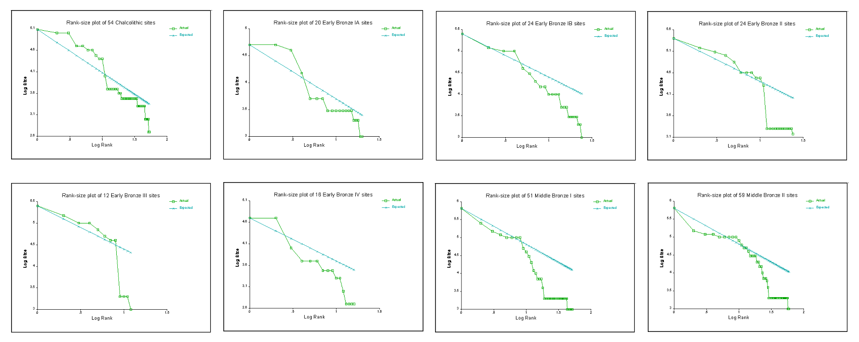
The 1997 paper outlined a custom Monte Carlo simulation algorithm designed to empirically establish a true baseline of statistical significance:
- Defining the Ideal Population: The program begins by generating a theoretical, perfectly log-normal population of settlements based on a specified maximum site size and a baseline exponent, assuming Ziph's q = 1.
- Empirical Random Drawing: The software simulates archaeological reality by repeatedly drawing random samples from this ideal population. It mimics factors like incomplete regional surveys or missing smaller rural sites.
- Calculating Empirical Critical Values: For every single random iteration (often run 1,000+ times), the program measures the maximum deviation from log-normality. By compiling thousands of these simulated deviations, the software calculates maps a customized probability distribution.
- Assessing True Significance: The program compares the actual, observed archaeological data against this simulated distribution. It calculates the exact probability that the observed curve's deviation could simply happen by random chance or sampling bias.
- Simulation v. Significance Tables: The simulations indicated that the threshold values for K- in standard statistics tables are far lower than those which result empirically. Their use results in rejecting the null hypothesis of no significant difference between observed and expected distributions far more often than required.
Data from a series of Chalcolithic through Middle Bronze IIB/C sites in the Levantine coastal plain were examined with the simulation. The results indicated that, except for the Early Bronze III period, all of the periods examined present significant departures from the Rank-size rule. Rank-size plots of the verified distributions indicate the possible existence of a relatively constant rural component in the coastal plain, which exhibits a central-place like distribution. Superimposed on this low-level rural component is a higher level urban distribution, which can be seen to develop, collapse, and redevelop during the periods in question, providing exciting new insights into the nature of Bronze Age urbanism in the Levant.
How Researchers Use the Paper:
- Altaweel, Mark, and Andrea Squitieri (2018) cite the 1997 paper in Chapter 3 ("Methodologies for Measuring Universalism"). The authors use the 1997 work strictly as a technical reference within their discussion on archaeological survey methodologies and measuring settlement structures. When analyzing ancient population distributions across the Near East, archaeologists use the "Rank-size rule" to see if a region is dominated by a single massive capital city (primate distribution) or a balanced network of medium towns (log-normal distribution). Savage (1997) introduced a specific mathematical method to measure exactly how much a real-world archaeological dataset "departs" from that perfect log-normal curve. Altaweel and Squitieri cite the paper to justify the specific statistical limits and mathematical formulas they use when modeling settlement systems later in the book.
- In Archaeological Survey, Banning, Edward Bruce (2002) cites the 1997 publication as a methodological reference for conducting Rank-size analyses and identifying urban settlement hierarchies. The text utilizes Savage's work to illustrate how ancient settlement systems relate to Zipf’s Law and regional population distributions.
- In Francesca Fulminante’s 2014 book, The Urbanisation of Rome and Latium Vetus, the author relies on the 1997 publication in Chapter 4 to establish theoretical rules regarding Rank-size and lognormal settlement distribution graphs. In subsequent comparative research such as Patterns of Etruscan Urbanism, Fulminante utilizes Stephen H. Savage’s 1997 paper ("Assessing departures from log-normality in the Rank-size rule") to apply mathematical formulas calculating the trajectory of ancient urban systems. These formulas help interpret how stabilizing systems naturally trend toward a lognormal layout over time.
Master Citation Index: Savage (1997) Derived from Google Scholar
Mapping for all references citing Savage, Stephen H. (1997) Assessing Departures from Log-normality in the Rank-Size Rule. Journal of Archaeological Science 24(3): 233-244.
| Author(s) / Date | Publication | Summary / Utilization |
|---|---|---|
| Agosto, Mara Beatriz (2025) | El Concepto de Paisaje en la Arqueología Procesual y sus Herramientas Conceptuales: An Overview [The Concept of Landscape in Processual Archaeology and its Conceptual Tools: An Overview]. Journal of Espacio Tiempo y Forma. Serie I, Prehistoria y Arqueología 18:83–111. | Traces the historiography of landscape archaeology, explicitly citing Savage's 1997 quantitative frameworks as a milestone transition for testing settlement systems beyond subjective visual curves. |
| Altaweel, Mark (2015) | Settlement Dynamics and Hierarchy From Agent Decision-Making: A Method Derived From Entropy Maximization. Journal of Archaeological Method and Theory 22(4):1122–1150. | Combines maximum entropy models with agent decision-making to dynamically simulate the deviations and structural departures from absolute log-normality discussed by Savage. |
| Altaweel, Mark, and Andrea Squitieri (2018) | Revolutionizing a World: From Small States to Universalism in the Pre-Islamic Near East. UCL Press, London. | Employs Rank-size curve metrics to trace macrocephalic and primate urban transitions in the pre-Islamic Near East, using Savage's baseline limits for empirical validation. |
| Arvanitidis, Paschalis, and Christos Kollias (2016) | Zipf’s Law and World Military Expenditures. Peace Economics, Peace Science and Public Policy 22(1):41–71. | Broadens the scope of Zipf's Law, applying Savage's statistical testing principles to analyze structural thresholds and departures in geopolitical datasets like global military expenditures. |
| Banning, Edward Bruce (2002) | Archaeological Survey. Springer, New York. | Outlines regional archaeological survey methodology, citing the 1997 article to guide how field investigators transform raw site distributions into formal Rank-size graphs. |
| Barker, Alexander Wade (1999) | Chiefdoms and the Economics of Perversity. Doctoral dissertation, Department of Anthropology, University of Michigan, Ann Arbor. | Uses Savage's Rank-size simulation boundaries to model the economic bottlenecks and structural collapse characteristics of non-log-normal prehistoric chiefdoms. |
| Bettencourt, Luís M. A., and José Lobo (2019) | Quantitative Methods for the Comparative Analysis of Cities in History. Frontiers in Digital Humanities 6:17. | Integrates scaling-law metrics to contrast primate, decentralized, and highly integrated historical city systems, using Savage's data validation baselines. |
| Bowman, Alan, and Andrew Wilson (2011) | Settlement, Urbanization, and Population. Oxford University Press, Oxford. | Tests early imperial Roman urbanization sizes using curve-fitting methodologies to measure true state centralization against log-normal expectations. |
| Caglioni, Matteo (2008) | Le Strutture Territoriali tra Ordine e Caso. Un Approccio Stocastico ai Modelli Localizzativi [Territorial Structures Between Order and Chance: A Stochastic Approach to Locational Models]. Doctor of Philosophy dissertation, Department of Architecture and Planning, Politecnico di Milano, Milan. | Constructs stochastic location models evaluating the balance of order and chance in settlement systems, citing Savage's evaluation of distribution anomalies. |
| Cavanagh, William (2009) | Territory in Prehistoric Laconia. British School at Athens Studies 16:55–65. | Examines prehistoric Laconian territorial hierarchies, applying Rank-size critiques to discern whether convex graphs signal fragmented polities. |
| Cottineau, Clémentine (2016) | MetaZipf: (Re)producing Knowledge About City Size Distributions. arXiv preprint arXiv:1606.06162. | Includes Savage 1997 in an extensive meta-analytical review of how diverse scientific fields process knowledge and track structural noise across urban size distributions. |
| Cottineau, Clémentine (2017) | MetaZipf: A Dynamic Meta-Analysis of City Size Distributions. PloS One 12(8):e0183919. | Performs a dynamic meta-analysis on the limits of Zipf's Law, testing how archaeological and historical data distributions deviate systematically from pure log-normal rules. |
| Creekmore, Andrew T., III (2018) | Landscape and Settlement in the Harran Plain, Turkey: The Context of Third-Millennium Urbanization. American Journal of Archaeology 122(2):177–208. | Analyzes the layout of third-millennium urbanization on the Harran Plain, utilizing Rank-size indicators to detect micro-regional system integration. |
| Crema, Enrico R. (2013a) | Cycles of Change in Jomon Settlement: A Case Study From Eastern Tokyo Bay. Antiquity 87(338):1169–1181. | Evaluates long-term Jomon settlement shifts over centuries, using Rank-size fluctuations as proxies for demographic and environmental changes. |
| Crema, Enrico R. (2013b) | Spatial and Temporal Models of Jomon Settlement. Doctoral dissertation, Institute of Archaeology, UCL (University College London), London. | Explores spatial and temporal models of prehistoric systems, deploying statistical critiques of standard distribution curves to identify system dynamics. |
| Crema, Enrico R. (2014a) | A Simulation Model of Fission–Fusion Dynamics and Long-Term Settlement Change. Journal of Archaeological Method and Theory 21(2):385–404. | Implements agent-based fission-fusion simulation logic to model spatial variations that capture the exact non-log-normal departures defined by Savage. |
| Crema, Enrico R. (2014b) | Modelling Settlement Rank-Size Fluctuations. In Agent-based Modeling and Simulation in Archaeology, edited by Gabriel Wurzer, Kerstin Kowarik, and Hans Reschreiter, pp. 161–181. Springer, New York. | Uses computer agents to simulate Rank-size behavior, generating artificial datasets to study why historical settlement systems exhibit distinct convex signatures over time. |
| D'Andrea, A. Catherine, Andrea Manzo, Michael J. Harrower, and Alicia L. Hawkins (2008) | The Pre-Aksumite and Aksumite Settlement of NE Tigrai, Ethiopia. Journal of Field Archaeology 33(2):151–178. | Measures Pre-Aksumite site size structures in Ethiopia, applying Rank-size models to identify fluctuating patterns of centralization and political fragmentation. |
| De Souza, Jonas Gregorio (2017) | Pathways to Power in the Southern Brazilian Highlands: Households, Communities and Status at Southern Proto-Jê Pit House Settlements. Doctoral dissertation, Department of Archaeology, University of Exeter, Exeter, UK. | Evaluates Southern Proto-Jê pit house community networks in Brazil, citing the 1997 methodology to test status disparities via settlement area distributions. |
| Dittmar, Jeremiah Edward (2009) | The Rise of European Cities: Technology, Institutions, and Growth. Doctoral dissertation, Department of Economics, University of California, Berkeley, Berkeley. | Documents the explosive growth of early European cities post-printing press, tracking deviations from log-normality using scaling frameworks. |
| Donev, Damjan (n.d.) | Patterns of Urban Settlement on and Behind the Danube Limes: A Geographical Perspective. Manuscript on file, Department of Archaeology, University of Leiden, Leiden. | Examines frontier Roman layouts near the Danube Limes, referencing Rank-size methods to differentiate military administrative structures from domestic economies. |
| Drennan, Robert D., and Christian E. Peterson (2004) | Comparing Archaeological Settlement Systems With Rank-Size Graphs: A Measure of Shape and Statistical Confidence. Journal of Archaeological Science 31(5):533–549. | Directly builds upon Savage's 1997 core argument regarding the weakness of classical KS tests, refining Monte Carlo sample-shape confidence bands for archaeological graphs. |
| Drzewiecki, Mariusz (2013) | Ufortyfikowane Zalozenia Architektoniczne w Kontekscie Osadniczym w Gornej Nubii w Czasach Krolestwa Makurii [Fortified Architectural Layouts in the Settlement Context of Upper Nubia During the Kingdom of Makuria]. Doctoral dissertation, Faculty of Historical Studies, Adam Mickiewicz University, Poznan, Poland. | Studies the spatial distribution of fortified medieval Nubian architecture, running Rank-size curve diagnostics to model royal versus autonomous border networks. |
| Duan, Tianjing (2015) | Dengji-Guimo Faze Zai Kaogu Quyu Fenxi Yanjiu Zhong de Xiangguan Wenti [Issues Concerning the Rank-Size Rule in Regional Archaeological Analysis]. Kaogu 4:108–120. | Delivers a critical evaluation of the Rank-size rule's application within East Asian archaeology, positioning Savage's work as a mandatory standard for testing sample completeness. |
| Falconer, Steven E., and Stephen H. Savage (2009) | The Bronze Age political landscape of the southern Levant. Polities and power: Archaeological perspectives on the landscapes of early states 1: 125. | Argue that the southern Levant during the Bronze Age was characterized by decentralized, cyclic, and modestly hierarchical communities rather than integrated city-states. They utilize the methodological framework from Savage (1997) to perform Monte-Carlo simulations, mathematically demonstrating that regional settlement patterns significantly deviated from log-normality, indicating sustained local rather than centralized control. |
| Fleisher, Jeffrey B. (2010) | Swahili Synoecism: Rural Settlements and Town Formation on the Central East African Coast, AD 750–1500. Journal of Field Archaeology 35(3):265–282. | Investigates Swahili town development patterns, evaluating non-log-normal settlement curves to show corporate, egalitarian urban integration rather than strict elite coercion. |
| Fulminante, Francesca (2014) | The Urbanisation of Rome and Latium Vetus: From the Bronze Age to the Archaic Era. Cambridge University Press, Cambridge. | Explores long-term urbanization curves across Latium Vetus, charting early Rome's rise from a decentralized regional cluster into a massive primate state center. |
| Griffin, Arthur F. (2011) | Emergence of Fusion/Fission Cycling and Self-Organized Criticality From a Simulation Model of Early Complex Polities. Journal of Archaeological Science 38(4):873–883. | Simulates early complex politics via self-organized criticality, using simulated Rank-size graphs to observe long-term systemic stability boundaries. |
| Haas, Randy (2012) | Prediciendo la Coalescencia en los Períodos Formativo y Tiwanaku en la Cuenca de Titicaca: Un Modelo Simple Basado en Agentes [Predicting Formative and Tiwanaku Period Coalescence in the Titicaca Basin: A Simple Agent-based Model]. In Arqueología de la Cuenca del Titicaca, Perú [Archaeology of the Titicaca Basin, Peru], edited by Luis Flores Blanco and Henry Tantaleán, pp. 243–260. Instituto Francés de Estudios Andinos, Lima; Cotsen Institute of Archaeology at UCLA, Los Angeles. | Implements agent-based coalescent modeling for the Lake Titicaca basin, comparing simulated prehistoric trajectories with observed Rank-size deviations. |
| Haller, Mikael John (2004) | The Emergence and Development of Chiefly Societies in the Río Parita Valley, Panama. Doctoral dissertation, Department of Anthropology, University of Pittsburgh, Pittsburgh. | Charts the trajectory of complex chiefdoms in Panama's Río Parita Valley, applying Rank-size shape signatures to calculate localized political competition. |
| Han, Haoying, and Shih-Kung Lai (n.d.) | Power Law Distribution of Urban Settlements—Empirical Study of China. Manuscript on file, Department of Land Management, Zhejiang University, Hangzhou, China. | Performs a long-term empirical power-law diagnostic across Chinese urban systems, referencing Savage's 1997 data validation steps for managing tail-end scale anomalies. |
| Hanson, John William (2016) | An Urban Geography of the Roman World, 100 BC to AD 300. Archaeopress, Oxford. | Compiles a massive macro-scale spatial geography of the entire classical Roman world, evaluating systemic deviations from Zipfian log-normality across regional provinces. |
| Hardy, Meredith D. (2009) | The St. Croix Archaeology Project and the Vescelius Collection: A Reexamination. Bulletin of the Peabody Museum of Natural History 50(1):99–118. | Re-evaluates Virgin Island survey collections, applying spatial scale parameters to map colonial-era interactive settlement distributions. |
| Harrison, Timothy P. (1997) | Shifting Patterns of Settlement in the Highlands of Central Jordan During the Early Bronze Age. Bulletin of the American Schools of Oriental Research 306(1):1–37. | Maps Early Bronze Age highland central Jordan settlement patterns, providing regional context for non-state urban integration that exhibits convex site curves. |
| Harrower, Michael J. (2006) | Environmental Versus Social Parameters, Landscape, and the Origins of Irrigation in Southwest Arabia (Yemen). Doctoral dissertation, Department of Anthropology, The Ohio State University, Columbus. | Measures the development of early irrigation systems in Southwest Arabia, contrasting ecological water parameters with Rank-size political trajectories. |
| Harrower, Michael J., and A. Catherine D’Andrea (2014) | Landscapes of State Formation: Geospatial Analysis of Aksumite Settlement Patterns (Ethiopia). African Archaeological Review 31(3):513–541. | Runs geospatial site-size diagnostics across Aksumite systems, testing for departures from expected log-normal curves to detect centralization shifts. |
| Harrower, Michael J., Joseph C. Mazzariello, A. Catherine D’Andrea, Smiti Nathan, Habtamu M. Taddesse, Ioana A. Dumitru, Carey E. Priebe, Kifle Zerue, Youngser Park, and Gidey Gebreegziabher (2023) | Aksumite Settlement Patterns: Site Size Hierarchies and Spatial Clustering. Journal of Archaeological Research 31(1):103–146. | Conducts spatial clustering analyses on Aksumite settlement hierarchies, utilizing updated Rank-size shape calculations to model state integration. |
| Henderson, Mark Gregory (2004) | Spatial Contexts of Urbanization and Land Conservation in North China. Doctoral dissertation, Department of Geography, University of California, Berkeley. | Examines urbanization dynamics in North China, utilizing quantitative curve evaluations to track how administrative boundaries bias standard power-law outputs. |
| Hofmann, Robert, J. Müller, and K. Rassmann (2007) | Sozio-politische Organisationsstrukturen und zentrale Institutionen des späthneolitishen Visokobeckens in Zentralbosnien (5500—4500 v. Chr) [Socio-political Organizational Structures and Central Institutions of the Late Neolithic Visoko Basin in Central Bosnia (5500—4500 BC)]. In Leben auf dem Tell als soziale Praxis, edited by Robert Hofmann, J.-K. Bertram, and M. Gleser, pp. 26–27. Habelt, Bonn. | Studies Late Neolithic Bosnian tell sites, running Rank-size metrics to reconstruct corporate, collective spatial planning models. |
| Houten, Pieter (2021) | Urbanisation in Roman Spain and Portugal: Civitates Hispaniae in the Early Empire. Routledge, London. | Compares Roman Iberian urbanization behaviors, checking provincial distributions against log-normal targets to identify distinct colonial commercial strategies. |
| Houten, Pieter Hubert Antoine (2018) | Civitates Hispaniae: Urbanisation on the Iberian Peninsula During the High Empire. Doctoral dissertation, Faculty of Archaeology, Universiteit Leiden, Leiden. | Traces the High Empire scale dynamics of the Iberian peninsula, using regional Rank-size charts to show variations in provincial center dominance. |
| Kalayci, Tuna (2013) | Agricultural Production and Stability of Settlement Systems in Upper Mesopotamia During the Early Bronze Age (Third Millennium BCE). Doctoral dissertation, Department of Anthropology, University of Arkansas, Fayetteville. | Simulates agricultural productivity limits in Upper Mesopotamia, analyzing how resource constraints systematically distort early Bronze Age Rank-size distributions. |
| Lai, Shih-Kung, and Haoying Han (2016) | Urban Complexity and Planning: Theories and Computer Simulations. Routledge, London. | Explores urban complexity simulations, evaluating how planning choices manipulate power-law patterns and shift distributions away from log-normality. |
| Levy, Thomas Evan, P. M. Michele Daviau, and Randall W. Younker (editors) (2007 & 2016) | Crossing Jordan: North American Contributions to the Archaeology of Jordan. Routledge, London. | Explores Jordan's archaeological history, compiling long-term survey records that use Rank-size methods to trace changing regional networks. |
| Ma, Minmin, Guanghui Dong, Xin Jia, and Zhancang Zhang (2012) | Qinghai Sheng Hualong Xian Xinshiqi-Qingtong Shidai Julei Xingtai Jilei Qiyingxiang Yinsu Fenxi [Analysis of Settlement Patterns and Modulating Factors of Neolithic-Bronze Age in Hualong County, Qinghai Province]. Disiji Yanjiu 32(2):209–218. | Analyzes Neolithic-Bronze Age configurations in Northwest China, evaluating site distributions to determine how shifts in farming strategies reshape settlement hierarchies. |
| Manuel, Mark James (2008) | Hidden Agendas: Testing Models of the Social and Political Organisation of the Indus Valley Tradition. Doctoral dissertation, Department of Archaeology, Durham University, Durham, UK. | Evaluates political models of the Indus Valley tradition, leveraging Rank-size signatures to argue for highly integrated, non-primate decentralized governance. |
| Montiel, Lisa M. (2010) | Teotihuacan Imperialism in the Yautepec Valley, Morelos. Doctoral dissertation, Department of Anthropology, State University of New York at Albany, Albany. | Measures the spatial signatures of Aztec imperialism in the Yautepec Valley, tracking how imperial conquest forced decentralized local systems into primate configurations. |
| Müller-Scheeßel, Nils (2013) | Heutige Theorien und ihre Anwendung [Current Theories and Their Application]. In Theorie in der Archäologie: Zur jüngeren Diskussion in Deutschland, edited by Manfred K. H. Eggert and Ulrich Veit, pp. 101–124. Waxmann Verlag, Münster. | Reviews quantitative theoretical applications in European archaeology, referencing Savage's 1997 work as a case study for rigorous mathematical testing. |
| Olson, Kyle Gregory (2020) | Models of Trade and Polity Formation in Bronze Age Northeastern Iran, CA. 3200-1600 Bce. Doctoral dissertation, Department of Anthropology, University of Pennsylvania, Philadelphia. | Investigates polity formation in Bronze Age Iran, evaluating micro-regional settlement distributions via shape metrics to understand localized trade networks. |
| Palmisano, Alessio (2017) | Confronting Scales of Settlement Hierarchy in State-Level Societies: Upper Mesopotamia and Central Anatolia in the Middle Bronze Age. Journal of Archaeological Science: Reports 14:220–240. | Maps Upper Mesopotamian and Central Anatolian Middle Bronze systems, directly using Savage’s Rank-size program to calculate exact departures from log-normality. |
| Palmisano, Alessio, and Mark Altaweel (2015) | Landscapes of Interaction and Conflict in the Middle Bronze Age: From the Open Plain of the Khabur Triangle to the Mountainous Inland of Central Anatolia. Journal of Archaeological Science: Reports 3:216–236. | Evaluates landscapes of warfare and conflict, modeling how intense geopolitical strife forces open plains into defensive, fragmented convex settlement arrays. |
| Purohit, Vanshita (2022) | Revolutionizing a World: From Small States to Universalism (Vol 2). The InfoLibrary, New Delhi. | Reviews theoretical models charting the transition from small peer-polities to centralized states, utilizing Rank-size indicators to diagnose political consolidation. |
| Qiao, Jiajun (2010) | Cunyu Jingji Yanjiu de International Jinzhan [International Progress of Village-level Economic Research]. Renwen Dili 25(2):24–30. | Reviews international micro-regional and village-level economic literature, citing Rank-size curves as metrics for measuring modern rural-urban migration imbalances. |
| Ristvet, Lauren (2008) | Legal and Archaeological Territories of the Second Millennium BC in Northern Mesopotamia. Antiquity 82(317):585–599. | Reconstructs second-millennium BC Mesopotamian legal boundaries, checking formal documentation against empirical site Rank-size graphs to locate missing administrative centers. |
| Sanders, Lena (2012) | Regards scientifiques croisés sur la hiérarchie des systèmes de peuplement: de l’empirie aux systèmes complexes [Crossed Scientific Perspectives on the Hierarchy of Settlement Systems: From Empiricism to Complex Systems]. Région et développement 36:127–146. | Bridges the gap between empirical geography and complex systems archaeology, positioning Savage's 1997 work as a foundational cross-disciplinary text on urban scaling. |
| Savage, Stephen H., and Steven E. Falconer (2003) | Spatial and Statistical Inference of Late Bronze Age Polities in the Southern Levant. Bulletin of the American Schools of Oriental Research 330(1):31–45. | Applies Savage's 1997 RankSize application metrics to track systemic shifts from Middle Bronze to Late Bronze southern Levantine polities. |
| Savage, Stephen H., Steven E. Falconer, and Timothy P. Harrison (2007 & 2016) | The Early Bronze Age City States of the Southern Levant: Neither Cities Nor States. In Crossing Jordan: North American Contributions to the Archaeology of Jordan, edited by Thomas Evan Levy, P. M. Michele Daviau, and Randall W. Younker, pp. 285–297. Routledge, London. | Leverages the 1997 Rank-size mathematical parameters to prove that Southern Levantine Early Bronze systems were neither fully integrated cities nor true centralized states. | Schmitt, Clara (2014) | Modélisation de la Dynamique des Systèmes de Peuplement: de SimpopLocal à SimpopNet [Modeling the Dynamics of Settlement Systems: From SimpopLocal to SimpopNet]. Thèse de doctorat, UMR 8504 Géographie-cités, Université Panthéon-Sorbonne-Paris I, Paris. | Uses SimpopNet multi-agent software to simulate macro-settlement trajectories, assessing simulated data outputs against Savage's empirical distribution rules. |
| Shukurov, Anvar, and Mykhailo Videiko (2017) | The Evolving System of Trypillian Settlements. arXiv preprint arXiv:1705.03398. | Examines mega-sites belonging to the Trypillian culture, using spatial network hierarchies to explain their highly unusual, non-log-normal nucleated layouts. |
| Smith, Michael E. (2009) | Just How Comparative Is Comparative Urban Geography? A Perspective From Archaeology. Urban Geography 30(2):113–117. | Critiques cross-cultural comparative urban geography methods, endorsing Savage's strict testing rules to avoid over-interpreting unverified settlement curves. |
| Smith, Michael E. (2011) | Empirical Urban Theory for Archaeologists. Journal of Archaeological Method and Theory 18(3):167–192. | Establishes empirical urban theory baselines for field archaeologists, presenting Rank-size deviation testing as a definitive workflow for identifying ancient macrocephalic systems. |
| Stoddart, Simon, Alessio Palmisano, David Redhouse, Graeme Barker, Giorgia Di Paola, Laura Motta, Tom Rasmussen, Troy Samuels, and Robert Witcher (2020) | Patterns of Etruscan Urbanism. Frontiers in Digital Humanities 7:1. | Models Etruscan city-state development patterns, applying mathematical boundary parameters to analyze primate transformations across competing regional centers. |
| Swantek, Laura Anne (2017) | A Change Is Going to Come: A Complex Systems Approach to the Emergence of Social Complexity on Cyprus. Doctoral dissertation, School of Human Evolution and Social Change, Arizona State University, Tempe. | Takes a complex systems approach to prehistoric Cypriot architecture, utilizing Rank-size variations to calculate the exact timing of social complexity breakthroughs. |
| Tsukayama, Hugo Cesar Ikehara (2015) | Leadership, Crisis and Political Change: The End of the Formative Period in the Nepeña Valley, Perú. Doctoral dissertation, Department of Anthropology, University of Pittsburgh, Pittsburgh. | Documents political crisis markers across Peru's Nepeña Valley, demonstrating how the collapse of Formative authority flatten Rank-size shapes into convex profiles. |
| Vis, Benjamin N. (2013a) | Mapping the Inhabited Urban Built Environment. Journal of Urban and ExtraUrban Studies 2(4):15–29. | Connects spatial boundary theory to urban datasets, evaluating how the physical limits of residential plots distort aggregate Rank-size properties over time. |
| Vis, Benjamin N. (2013b) | Mapping the Inhabited Urban Built Environment. The Socio-Spatial Significance of the Material Presence of Boundaries Through Time. Doctoral dissertation, School of Geography, University of Leeds, Leeds, UK. | Deploys spatial boundary indicators across long-term urban records, citing Savage's 1997 paper to track deviations caused by changing land-use patterns. |
| Vis, Benjamin N. (2018) | Cities Made of Boundaries: Mapping Social Life in Urban Form. UCL Press, London. | Develops an integrated socio-spatial mapping methodology for urban environments, assessing systemic layout hierarchies through quantitative scaling distributions. |
| Whitelaw, T. M. (2014) | Recognising States in Prehistoric Crete. Oxbow Books, Oxford. | Tests early state trajectories across Prehistoric Crete, evaluating Minoan regional surveys via Rank-size modeling to determine true centralization. |
| Whitelaw, Todd, M. Relaki, and Y. Papadatos (2018) | Recognising Polities in Prehistoric Crete. In From the Foundations to the Legacy of Minoan Archaeology, edited by M. Relaki and Y. Papadatos, pp. 210–255. Oxbow Books, Oxford. | Analyzes peer-polity configurations across Bronze Age Crete, matching convex Rank-size signatures with independent, competing palatial centers. |
| Wiederick, Brock (2020) | Archaeological Site Distribution and the Formation of Early Polities in Eastern Tigrai (Agame), Ethiopia. Master's thesis, Department of Archaeology, Simon Fraser University, Burnaby, BC, Canada. | Traces early polity patterns across Eastern Tigrai, utilizing macro-level site-size distribution tables to estimate pre-Aksumite demographic hierarchies. |
| Wilkinson, Tony J. (2000) | Regional Approaches to Mesopotamian Archaeology: The Contribution of Archaeological Surveys. Journal of Archaeological Research 8(3):219–267. | Synthesizes Mesopotamian settlement survey histories, warning that fragmentation, survey biases, and alluvium coverage mimic the exact Rank-size deviations modeled by Savage. |
| Xue, Mingsheng, and Shigang Lai (2002) | Renkou Shikong Fenbu Mici Dinglv de Pubianxing yu Hengchangxing: Taiwan Bendao Shizheng Yanjiu [The Universality and Constancy of the Power Law Distribution of Population in Space and Time: An Empirical Study of Taiwan Island]. Journal of Taiwan Land Research 5:67–86. | Tests the spatial universality of power-law dynamics across historical Taiwan networks, using Savage's 1997 parameters to calibrate regional data constraints. |
| Xue, Mingsheng, and Shigang Lai (2009) | Caizheng Zhengce dui Renkou Qianyide Yingxiang: Taiwan Diqu Faza Tujing Jianzheng [The Effects of Fiscal Policies on Population Migration: An Empirical Validation of Complex Approach in Taiwan]. Complex Systems and Complexity Science 6(2):9–14. | Explores how fiscal policy manipulations warp population migration flows, validating the systemic departures via complex systems tracking methods. |
| Yu, Juling, and Shigang Lai (2004) | Julei Tixi Xingcheng zhi Diannao Moni Shiyan: Butong Hanshu Xingtaixia de Tantao [Computer Experiments on Formation of Settlement Systems: An Exploration Based on Multiple Functional Forms]. Journal of Taiwan Land Research 7(2):71–99. | Conducts large-scale computer simulation experiments on settlement generation under distinct mathematical functions, matching structural anomalies directly to Savage's log-normal index thresholds. |
| Yukich, Sarah T. Cult. (2013) | Spatial Dimensions of Social Complexity: Environment, Economy, and Settlement in the Jabbul Plain, 3000–550 BC. Doctoral dissertation, Department of Near Eastern Studies, The Johns Hopkins University, Baltimore. | Investigates Bronze Age social complexity inside the Jabbul Plain, evaluating empirical survey tables via Rank-size parameters to trace changing corporate economic zones. |
Multi-Scalar Clustering and the Amarna Letters (Savage and Falconer 2003)
In "Spatial and Statistical Inference of Late Bronze Age Polities in the Southern Levant" (Bulletin of the American Schools of Oriental Research (BASOR)), the analytical framework was expanded by pairing Monte Carlo Rank-size testing with K-means Cluster Analysis Here, Savage and Falconer use the methods developed by Savage to create a statistically based model of the Late Bronze Age in the southern Levant, and compare it to polities drawn by reference to the Amarna Letters and large sites. The 2003 paper fundamentally changed how historians and archaeologists map ancient political landscapes. The paper has been cited approximately 60 to 80 times. It remains a foundational text because it solved a classic problem: how to prove whether historical texts (like the Egyptian Amarna Letters) match actual ground-level archaeology.
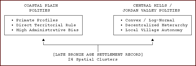
The Core Methodology: Savage and Falconer used K-means spatial clustering and geographic data from thousands of documented archaeological sites. Instead of just drawing arbitrary circles around famous capital cities mentioned in texts, their computer models grouped actual town and village data to let the borders form naturally. Their findings mathematically demonstrated that the Late Bronze Age Levant was "balkanized"--divided into dozens of tiny, highly competitive, and structurally diverse city-states. Rather than treating the southern Levant as an undifferentiated regional whole, the K-means algorithm mathematically partitioned hundreds of Late Bronze Age (LBA) settlement locations into 24 distinct spatial clusters. Once these territorial boundaries were delineated, rank-size simulations were executed within each discrete polity.
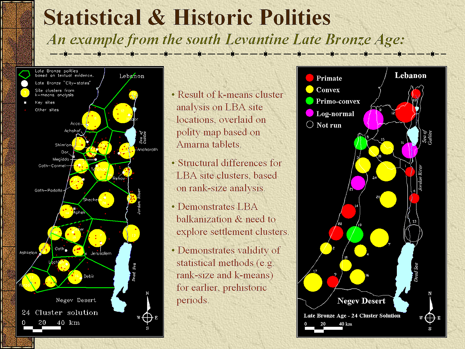
This model provided an independent, site inventory-based validation of the Amarna Letters (14th century BCE cuneiform correspondence between Levantine vassal rulers and the Egyptian New Kingdom). After assembling an extensive list of Late Bronze Age settlements from published sources and the files at the Israel Antiquities Authority, we conducted a K-means cluster analysis on their locations, and overlaid the best cluster solution on a digitized map--Figure 6 from Shlomo Bunimovitz's (1995) publication of Theissen polygons based on the "city-states" identified in the Amarna Letters.
- Balkanized Political Landscape: The computational clustering confirmed that Late Bronze Canaan was not governed by unified regional states, but was fragmented into competitive, localized peer polities ("petty kingdoms") with restricted territorial reach.
- Geographic Structural Divergence: Polities situated on the Coastal Plain exhibited primate distributions, reflecting centralized administrative control over agrarian hinterlands. Conversely, polities in the Central Hills and the Jordan Valley exhibited convex or log-normal distributions, confirming the fragmented, decentralized, and contested administrative authority explicitly described by local rulers such as Biridiya of Megiddo and Labayu of Shechem.
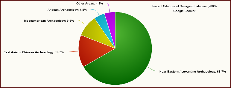
The 2003 paper, Spatial and Statistical Inference of Late Bronze Age Polities in the Southern Levant, is actually highly self-contained. It is a dense, deeply specialized computational paper. The 2003 paper did exactly what spatial archaeology is supposed to do: it provided an empirical, bottom-up check on top-down textual histories. Before their work, historians looked at the Amarna Letters, saw the names of major city-states (like Megiddo, Jerusalem, or Shechem), and just assumed those capitals smoothly controlled everything around them. We threw actual archaeological site distributions into an algorithm to see if those political borders made sense on the ground. They showed that the Levant was deeply "balkanized"—showing that geography (the Coastal Plain vs. the Central Hills vs. the Jordan Rift) fundamentally dictated how these polities were structured. Because it bridges the gap between raw data and political history, the 60+ citations of the paper (from Google Scholar and ResearchGate) generally come from three very real groups of scholars:
- Regional Survey Projects: Archaeologists completing sweeping regional surveys in Israel, Jordan, and Palestine use it to contextualize their own localized findings within the broader macro-regional landscape Savage and Falconer modeled.
- Scholars of the Amarna Age: Historians and text-based scholars writing about Egyptian New Kingdom hegemony over Canaan use it to understand the actual demographic and geographic limits of the "kings" who were writing those letters.
- Iron Age Transition Studies: Researchers tracking the collapse of the Late Bronze Age cite it as the baseline map for what Canaan looked like before the systemic social re-organization of the early Iron Age.
When researchers cite the 2003 article, they are usually doing so for three reasons:
- To justify using K-means clustering: Researchers use it as a precedent to prove that an algorithm can successfully group ancient sites together without relying entirely on biased ancient texts (like the Amarna Letters). Eva Kaptijn and Lucas P. Petit note that "These texts, primarily correspondence from petty Canaanite rulers to the pharaohs Amenophis III and Amenophis IV (Akhenaten), allude to a checkerboard of small polities across the Levantine landscape, each maneuvering for the favors of the Egyptian crown (Moran 1992). A series of critical studies infer 20-30 such polities and K-means cluster analysis concurs with the locations of most of these polities by suggesting 24 settlement clusters or potential polities during the Late Bronze Age (Savage and Falconer 2003)." Kaptijn, Eva & Petit, L.P.. (2009). A timeless vale. Archaeological and related essays on the Jordan Valley in honour of Gerrit van der Kooij on the occasion of his sixty-fifth birthday. Leiden, Leiden University Press.
- To reference the "Balkanization" map: Scholars cite it simply to reference Savage and Falconer's specific calculation that the Late Bronze Age Southern Levant was split into roughly 24 fragmented micro-regions. An example is Nava Panitz-Cohen's, in "The Southern Levant (Cisjordan) during the Late Bronze Age" (2013) In The Oxford Handbook of the Archaeology of the Levant (c. 8000-332 BCE) (pp.535-554) Chapter: 36 . Oxford University Press. Editors: M.L. Steiner and A.E. Killebrew. Panitz-Cohen cites the 2003 study to demonstrate that Late Bronze political-territorial organization represented a more diverse and less integrated [i.e. Balkanized] system than in the Middle Bronze.
- To compare their balkanized settlement system to regions beyond the Levant: Bevan contrasts the political geography of Palatial Crete with the more closely packed kingdoms of the south--central Levant[Bevan, Andrew. (2010). Political Geography and Palatial Crete. Journal of Mediterranean Archaeology. 23. 27-54. 10.1558/jmea.v23i1.27.]
Master Citation Index: Savage & Falconer (2003) Derived from Google Scholar
Mapping references citing Savage, Stephen H., and Steven E. Falconer. 2003. "Spatial and Statistical Inference of Late Bronze Age Polities in the Southern Levant." Bulletin of the American Schools of Oriental Research 330: 31–45.
Scope: 56 verified bibliographical entries tracing the replication, expansion, and critique of K-means spatial settlement clustering and Amarna-era territorial modeling.
| Author(s) / Date | Publication | Summary / Utilization |
|---|---|---|
| Bevan, Andrew (2010) | Political Geography and Palatial Crete. Journal of Mediterranean Archaeology 23(1):27–54. | Contrasts the spatial scale and political geography of Aegean palatial states with the hyper-fragmented, tightly packed Canaanite city-states. |
| Bourke, Steven (2013) | The Southern Levant (Transjordan) during the Middle Bronze Age. | Applies regional settlement sizing and spatial clustering parameters to define town-to-village interaction nets across Transjordan. |
| Creekmore, Andrew T., III, & Aren M. Maeir (2021) | Philistine Urban Form at Tell es-Safi/Gath, Israel: A Magnetometric Perspective. Levant 53(2):164–185. | Employs site clustering limits to understand how early Iron Age Philistine layouts emerged out of the fractured Late Bronze political landscape. |
| Damm, Jacob Carl (2021) | Conflict and Consumption: Foodways, Practice, and Identity at New Kingdom Jaffa. Ph.D. dissertation, UCLA. | Frames how Egyptian New Kingdom imperial governance structurally modified localized foodways and independent trade patterns within Levantine polities. |
| Dell, Katharine J. (2021) | The Biblical World. Routledge, London. | Adopts territorial mapping paradigms to define physical and geographic borders of Bronze-Age polities mentioned in historical archives. |
| El Safadi, Crystal (2013) | Faculty of Humanities. Ph.D. dissertation, University of Southampton. | Critiques flat spatial clustering for overlooking coastal-marine and maritime trade dynamics which alter inland boundary ranges. |
| Eshel, Tzilla (2025) | ‘Keseph’: The Use of Silver Money in the Southern Levant from the Middle Bronze Age to the End of the Iron Age (~ 2000–600 BC). Journal of World Prehistory 38(2):5–32. | Cross-references early silver hoard distributions with the 24 modeled polities to observe if currency circulated along autonomous state boundaries. |
| Falconer, Steven E. (n.d.) | A Comparison of Vegetation and Settlement. Manuscript on file. | Direct self-extension tracking how the 2003 settlement boundaries overlay ancient environmental data and deforestation patterns. |
| Falconer, Steven E., & Patricia L. Fall (2009) | Settling the Valley: Agrarian Settlement and Interaction along the Jordan Rift during the Bronze Age. | Uses original K-means clustering output to analyze long-term rural-urban socioeconomic dynamics specific to Jordan Valley sites. |
| Falconer, Steven E., & Patricia L. Fall (2016) | A Radiocarbon Sequence from Tell Abu en-Ni ‘aj, Jordan and Its Implications for Early Bronze IV Chronology in the Southern Levant. Radiocarbon 58(3):615–647. | Utilizes regional baseline coordinates to track demographic shifts as large administrative hubs dissolved into decentralized villages. |
| Falconer, Steven E., & Patricia L. Fall (2022) | Sacred Spaces and Liminal Behavior in Levantine Temples in Antis. Journal of Ancient Near Eastern History 9(2):259–284. | Evaluates the deliberate geographic placement of specialized religious structures along the outer, liminal fringes of calculated polity boundaries. |
| Fall, Patricia L. (n.d.) | Landuse and Landscape Socioecology in the Mediterranean Basin... National Science Foundation. | Integrates empirical site catchments into eco-archaeological datasets to gauge ancient soil and vegetation degradation caused by farming. |
| Fall, Patricia L., Mariela Soto-Berelov, Elizabeth Ridder, & Steven E. Falconer (2017) | Toward a Grand Narrative of Bronze Age Vegetation Change and Social Dynamics in the Southern Levant. | Feeds the exact geospatial cluster limits into broad digital modeling layers to analyze long-term human-landscape socioecology. |
| Fischer, Peter M. (2006) | The Chronology of the Jordan Valley during the Middle and Late Bronze Ages: Pella, Tell Abu al-Kharaz and Tell Deir cAlla. | Contextualizes excavation sequences in the central Jordan Valley against the multi-tiered site hierarchies outlined in the 2003 study. |
| Gardner-Cook, Ryan (2019) | Diversity, Connectivity & Organization... Ph.D. dissertation, Stony Brook University. | Extracts geographic coordination grids to run mathematical simulations of how complex polities adapt or succumb to climate stressors. |
| Glazer, Eva Katarina (2012) | Polunomadsko i ruralno društvo i proces urbanizacije na prostoru Sirije i Palestine u brončano i željezno doba. Ph.D. dissertation, Zagreb. | Tests modeled territorial perimeters against regional material evidence for semi-nomadic and mobile populations in the Syrian desert fringes. |
| Grabbe, Lester L. (2008) | Reflections on the Discussion. In Israel in Transition, pp. 219–226. | Reconciles late 13th-century settlement density declines with text-based accounts of shifting tribal and state interactions. |
| Grabbe, Lester L. (2016) | The Land of Canaan in the Late Bronze Age. Bloomsbury T&T Clark, London. | Incorporates the 24-cluster layout as a baseline political map illustrating the division of independent Canaanite versus Egyptian vassal lands. |
| Green, John DM (2006) | Ritual and Social Structure in the Late Bronze and Early Iron Age Southern Levant: The Cemetery at Tell es-Sa'idiyeh, Jordan. Ph.D. dissertation, UCL. | Employs the site-hierarchy model to track the specific socioeconomic rank and outer hinterland influence of Tell es-Sa'idiyeh's populations. |
| Griffin, Arthur F. (2011) | Emergence of Fusion/Fission Cycling and Self-Organized Criticality from a Simulation Model of Early Complex Polities. JAS 38(4):873–883. | Translates K-means spatial polygons into discrete agent variables to simulate cyclical rise, consolidation, and fragmentation of early polities. |
| Homsher, Robert S., & Melissa S. Cradic (2021) | Palestine during the Bronze Age. In The Biblical World, pp. 429–451. | Utilizes the 2003 settlement cluster groupings to structure their handbook overview of regional Middle and Late Bronze administrative networks. |
| Janica, Giancarlo Macchi (2009a) | Spazio e Misura. Vol. 1. Giancarlo Macchi, Siena. | Uses the paper as a prime historical case study demonstrating the execution of quantitative spatial statistics within automated archeology programs. |
| Janica, Giancarlo Macchi (2009b) | Spazio e Misura: Introduzione ai metodi geografico-quantitativi applicati allo studio dei fenomeni sociali. Edizioni dell'Università, Siena. | Evaluates the mathematical legitimacy of applying cluster algorithms onto localized archaeological site patterns to solve political borders. |
| Johnston, Christine Leigh (2016) | Networks and Intermediaries: Ceramic Exchange Systems in the Late Bronze Age Mediterranean. Ph.D. dissertation, UCLA. | Plots chemical/stylistic ceramic distributions across the 24 clusters to test whether pottery traveled via centralized markets. |
| Jorgenson, Jason Scott (2009) | The Impact of South Levantine Early Bronze Age Communities on Their Landscapes. Ph.D. dissertation, University of Liverpool. | Computes regional wood, fuel, and resource depletion boundaries radiating out from major town points based on spatial density maps. |
| Kennedy, Titus Michael (2013) | A Demographic Analysis of Late Bronze Age Canaan: Ancient Population Estimates and Insights through Archaeology. Ph.D. dissertation, UNISA. | Relies on the documented site-sizes and cluster ranges to calculate baseline human population figures across ancient Canaan. |
| Khalifa, Sherif (2026) | The Late Bronze Age Crisis. In Climate Change, Economic Channels, and Historical Junctures, pp. 201–225. Springer, Berlin. | References the non-unified, balkanized nature of the countryside to argue why small city-states easily succumbed to systemic climate collapse. |
| Khatchadourian, Lori (2008) | Social Logics under Empire: The Armenian ‘Highland Satrapy’ and Achaemenid Rule, ca. 600–300 BC. Ph.D. dissertation, University of Michigan. | Adapts the spatial boundary classification methods to contrast Levantine formats with Achaemenid imperial frameworks in Armenia. |
| Killebrew, Ann E. (2012) | Biblical Peoples and Ethnicity: An Archaeological Study of Egyptians, Canaanites. Vol. 9. SBL, Atlanta. | Integrates physical site organization with localized material evidence to trace shifting cultural, ethnic, and political boundaries. |
| Kowalewski, Stephen A. (2008) | Regional Settlement Pattern Studies. Journal of Archaeological Research 16(3):225–285. | Highlights the paper in a global methodology review as a definitive example of using K-means clustering to resolve ambiguous historical boundaries. |
| Levy, Thomas Evan, P. M. Michele Daviau, & Randall W. Younker (2007 & 2016) | Crossing Jordan: North American Contributions to the Archaeology of Jordan. Routledge, London. | Summarizes and incorporates the authors' long-term computational mapping of Jordan Rift Valley site sequences. |
| Liverani, Mario (2016) | Imagining Babylon: The Modern Story of an Ancient City. Vol. 11. Walter de Gruyter, Berlin. | Contrasts the expansive territorial empires of Mesopotamia with the small-scale, fractured micro-polities of the Levant. |
| Mariani, Guido S., Filippo Brandolini, & Rita T. Melis (2024) | Mining, Farming, and Diplomacy: Understanding the Human Landscape of Bronze Age Sardinia (Italy) through Geospatial Analysis. Quaternary Environments and Humans 2(5):100025. | References the 2003 mathematical framework to justify applying spatial statistical point patterns to Nuragic landscapes in Sardinia. |
| Martín García, José M. (2020) | The Central Levantine Economic System at the End of the Late Bronze Age (1350-1230 BCE): The Case of the Lower Qishon. Ph.D. dissertation, Barcelona. | Employs territorial footprint measurements to establish economic reach and micro-trade boundaries inside the Lower Qishon Valley. |
| Negbi, Ora (2005) | Urbanism on Late Bronze Age Cyprus: LC II in Retrospect. BASOR 337(1):35–45. | Compares Cypriot settlement density layouts against the highly nucleated mainland Canaanite center points mapped in 2003. |
| Olson, Kyle Gregory (2020) | Models of Trade and Polity Formation in Bronze Age Northeastern Iran, CA. 3200-1600 Bce. Ph.D. dissertation, UPenn. | Replicates the K-means boundary classification on Iranian site databases to map the spectrum between loose versus centralized networks. |
| Ortiz, Steven, & Samuel Wolff (2019) | A Reevaluation of Gezer in the Late Bronze Age in Light of Renewed Excavations and Recent Scholarship. | Evaluates Gezer’s shifting military and political prominence relative to the boundaries of neighboring, competitive city-states. |
| Palmisano, Alessio (2017) | Confronting Scales of Settlement Hierarchy in State-Level Societies: Upper Mesopotamia and Central Anatolia in the Middle Bronze Age. JAS: Reports 14:220–240. | Builds directly upon the 2003 critique of simple site-size models, executing advanced Rank-size equations in Anatolia. |
| Panitz-Cohen, Nava (2013) | The Southern Levant (Cisjordan) during the Late Bronze Age. | Re-analyzes and prints the 2003 map clusters to review competing theories for how Canaanite administrative borders are drawn. |
| Pfoh, E. (2009) | Some remarks on patronage in Syria-Palestine during the Late Bronze Age. Journal of the Economic and Social History of the Orient, 52(3), 363-381. | Argues that socio-political power in the ancient Levant operated through patrimonial and patron-client structures rather than modern statehood. Across his works, Pfoh strategically employs Savage and Falconer's 2003 spatial and statistical settlement data to anchor his anthropological and historical models in the physical geography of the southern Levant. |
| Pfoh, E. (2016a) | Syria-Palestine in the Late Bronze Age: An anthropology of politics and power. Routledge. | An anthropological reading of socio-political dynamics in the ancient southern Levant, arguing that political organization relied on a patrimonial ontology and personal patron-client relationships rather than modern statehood. Pfoh integrates the spatial and statistical analyses of Savage and Falconer (2003) to validate a geographic balkanization of the region, which structurally precluded centralized bureaucratic states and supported autonomous site clusters operating through flexible allegiances. |
| Pfoh, E. (2016b) | The Emergence of Israel in Ancient Palestine: historical and anthropological perspectives. Routledge. | Reconstructs the origins of historical Israel as a flexible highland patronate rather than a centralized state. Integrates the regional settlement data of Savage and Falconer (2003) to empirically demonstrate the decentralized, balkanized landscape of the southern Levant that supported this patrimonial model. |
| Pfoh, E. (2019) | Prestige and authority in the Southern Levant during the Amarna Age. The Late Bronze and Early Iron Ages of Southern Canaan, 2, 247. | reevaluates Late Bronze Age Canaanite vassal states, arguing that local political structures operated through informal patron-client networks and patrimonial hierarchies rather than modern state bureaucracy. Utilizes the regional settlement analysis and statistical data from Savage and Falconer (2003) to demonstrate spatial fragmentation, validate the existence of small-scale petty kingdoms, and explain local elites' reliance on external Egyptian prestige. |
| Pullen, Daniel J. (2021) | The Political Geography of the Late Bronze Age Argolid States and Territories. | References the Levantine model to contrast competing political layout schemes in the Aegean using GIS walking radii. |
| Redman, Charles (2004) | Landuse and Landscape Socioecology in the Mediterranean Basin: A Natural Laboratory for the Study of the Long-Term Interaction of Human and Natural Systems International, Interdisciplinary Research Supported by the National Science Foundation Biocomplexity in the Environment Program. | Incorporates the spatial cluster coordinates to frame broad ecosystem changes and human-induced land alteration around major ancient centers. |
| Roberts, Gareth, & Christoph Bachhuber (2012) | Forces of Transformation: The End of the Bronze Age in the Mediterranean. Oxbow Books, Oxford. | Cites the hyper-balkanized regional model to argue why uncoordinated Canaanite town clusters failed to survive regional geopolitical stress. |
| Routledge, Carolyn (2020) | Western Asia. In The Oxford Handbook of Egyptology, pp. 514–539. | Juxtaposes New Kingdom Pharaoh administrative texts against the physical settlement layouts proven on the ground by Savage and Falconer. |
| Savage, Stephen H., Steven E. Falconer, & Timothy P. Harrison (2007 & 2016) | The Early Bronze Age City States of the Southern Levant: Neither Cities nor States. In Crossing Jordan, pp. 285–297. | Direct self-citation applying 2003 mathematical metrics backwards to older Early Bronze data to track long-term evolution of urban clusters. |
| Schaaf, James Mark (2012) | A Historical, Geographical and Archaeological Survey of the Jordan Valley in the Late Bronze Age. Ph.D. dissertation, UNISA. | Directly plots new field survey discoveries inside the Jordan Valley onto the exact site ranking scales calculated in the 2003 database. |
| Starr, Laurie (2018) | The Sea Peoples: The Warriors Behind the Infamy. Master's thesis, Flinders University. | Argues that migrating Sea Peoples easily fragmented coastal zones due to the uncoordinated, multi-polity borders mapped by the authors. |
| Titolo, Andrea, & Alessio Palmisano (2026) | A Tale of Two Regions: Cyclical Human-Climate Interactions in the South Levant from the Chalcolithic to the Iron Age (6500–2200 BP). Quaternary Science Reviews 375:109777. | Inputs the settlement coordination files into computer algorithms to gauge demographic density expansions/retractions during massive droughts. |
| van Wijngaarden, Gert Jan, & Jan Driessen (n.d.) | Political Geographies of the Bronze Age Aegean. | Cites the paper as a core example of using statistical spatial packages to resolve historical text-based borders. |
| Wankowski, Jacek Wieslaw Jerzy (2022) | A Reimagined Past... Technical Report/Thesis on file. | Contrasts highly sedentary farming center calculations with flexible, mobile pastoral territorial maps along dry zones. |
| Wood, Brian M., & Zoë J. Wood (2006a / 2006b) | Energetically Optimal Travel Across Terrain... SPIE Proceedings Vol. 6060. | Critiques Savage and Falconer's straight-line "as-the-crow-flies" boundary radii, replacing them with terrain-based "least-cost travel times" to build realistic boundaries. |
| Yukich, Sarah TK (2013) | Spatial Dimensions of Social Complexity: Environment, Economy, and Settlement in the Jabbul Plain, 3000–550 BC. Ph.D. dissertation, Johns Hopkins. | Transports the identical K-means clustering workflow to map Bronze Age settlement distributions across the Jabbul Plain in Syria. |
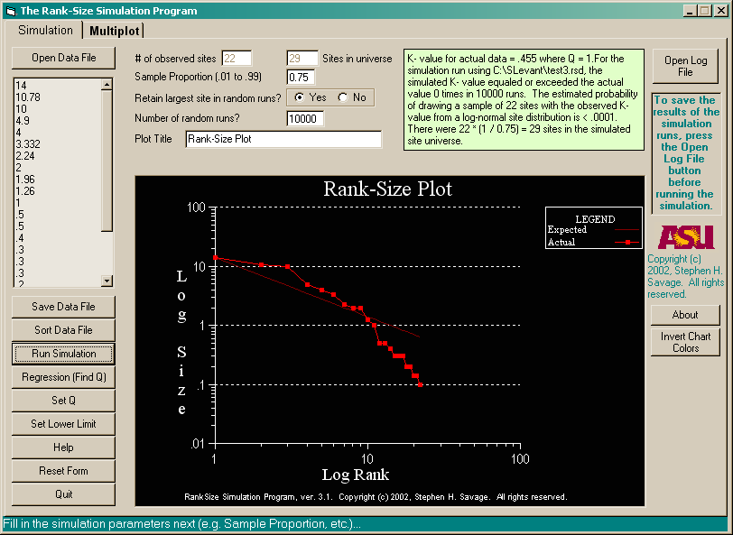
Updating RankSize
The culmination of the analytical engine was realized in the transition of the codebase to a 32-bit standalone application: RankSize v3 (Visual Basic Edition). The RankSize v2 program, described earlier, was written with the final DOS version of Turbo Pascal 7.0, released on October 27, 1992. By the time we began working on the 2003 article--the research was done in 2001-2002--a much better Windows-based environment dominated the PC market, and I wrote RankSize v3 in 2002 using Visual Basic 5.0 Control Creation Edition. Major upgrades to the program included a much smoother user interface and the curve plotting ability, which required me to write a custom log-log line plotting control, hence the use of the Control Creation Edition of the Visual BASIC IDE.
By releasing the software freely to the archaeological community, the program provided a unified graphical interface that automated the mathematical corrections developed since 1991:
- Direct Calculation of Zipf’s Exponent (q): Rather than assuming an idealized q = 1.0, the software utilized least-squares linear regressions across log-log arrays to calculate the true empirical value of q, providing an objective measure of system-wide centralization.
- Correction for the Lower-Limb Problem: The application integrated automated truncation functions, allowing researchers to model the effect of missing smaller settlement tiers and generate corrected simulation envelopes that isolated upper-tier political structure from lower-tier recovery bias.
- Multi-Plot Diachronic Overlays: The interface enabled researchers to overlay multiple archaeological phases and geographic zones simultaneously, facilitating direct comparative analysis of regional restructuring over time.
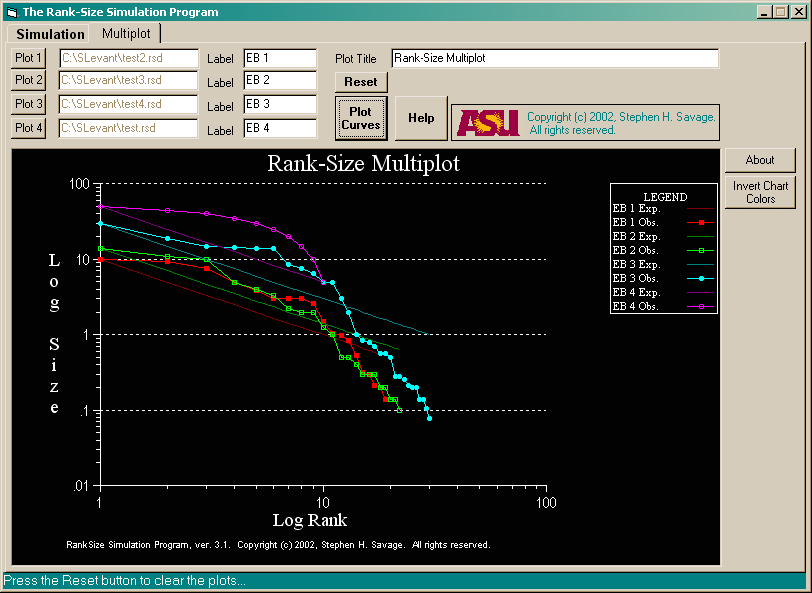
The Multiplot Tab on the RankSize Program screen opens the Multiplot form. For the sake of convenience, I've already filled in parameters for the plots, to illustrate how a multiplot appears. Note that this form lets the user create multiple line Rank-size plots, but it does not alolow things like set the value of Q or the lower limit for a plot. There is no simulation function; the program simply plots lines, so up to four different data sets can be compared. The Plot Curves button causes the program to plot all the curves that have been set up so far. It can be pressed after each set of input data is designated, or wait until all the desired plot lines are set up. It doesn't matter. When this button is pressed, the program looks through all the data sets designated and finds the largest and smallest site sizes, and the largest number of sites. It uses these values to recalculate the multiplot x- and y-axis, so all the data from all the plots are displayed.

program that summer, with the help of a geologist from the European Petroleum Survey Group,
who helped me nail down the parameters of the Jordan Transverse Mercator map projection.
Macro-Regional Synthesis and the Deconstruction of "City-States" (2007–2009)
The subsequent maturation of this research trajectory integrated spatial simulation into macro-regional comparative syntheses, challenging classic evolutionary taxonomies that had categorized Early Bronze Age societies as standardized "city-states."
Overturning the Early Bronze Age City-State Paradigm (2007)
Meredith Chesson and Raphael Greenberg wrote foundational papers in the late 1990s and early 2000s arguing that Levantine towns were corporate and lacked stark social hierarchies. Savage, Falconer, and Harrison (2007) used a massive database to provide statistical GIS backing to those ideas, coining the phrase that these settlements were "neither cities nor states.

localized, and non-primate network characteristic of the Early Bronze Age Levant.
Savage, Falconer, and Harrison's 2007 paper, "The Early Bronze Age City States of the Southern Levant: Neither Cities Nor States" aggregated regional survey datasets from the southern Levant and Jordan to argue that Early Bronze Age fortified sites the region were not true urban city-states, but rather heterarchically organized, collaborative corporate communities. By combining the mathematical modeling of Rank-size and K-means analyses with massive spatial datasets, the authors delivered a direct challenge to the conventional terminology of Near Eastern archaeology. The work serves as a foundational critique of Levantine urbanization models, widely cited by scholars to support "rural complexity" models, while simultaneously being contrasted by other researchers who uphold the evidence for centralized city-states in the Western Levant. The paper has become a cornerstone text for scholars debating the exact nature of complex societies in the ancient world.
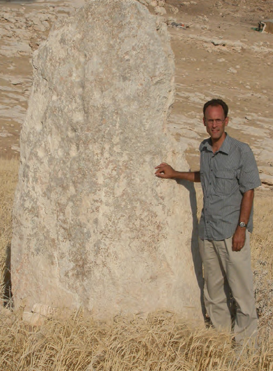
How the 2007 Paper Directly Relates to the Earlier Publications: This paper synthesizes decades of methodology and theory into a single, cohesive argument about the Early Bronze Age (EBA):
- From "Alternative Trajectories" (1995) to Rejection of Terms (2007): In 1995, Falconer and Savage argued that the Levant had an alternative path to urbanization compared to Mesopotamia. By 2007, with the addition of Timothy Harrison’s expertise on the EBA, they went a step further, arguing that the words "City" and "State" should not be used for the EBA Levant at all.
- Scaling Up the 1997 Simulation Methodology: The 1997 Journal of Archaeological Science paper tested small regional datasets for log-normality. The 2007 paper scaled this up drastically by running those exact Monte Carlo simulation models across the massive Jordan Antiquities Database and Information System (JADIS), analyzing hundreds of sites simultaneously to prove that settlement patterns across the entire Jordan Valley were consistently decentralized.
- Evolving from the Late Bronze Age (2003) Model: While their 2003 paper proved that the Late Bronze Age had tiny, "balkanized" city-states matching the Amarna letters, the 2007 paper demonstrated that the earlier EBA lacked even those fragmented state structures. Instead of isolated political nodes, the EBA featured overlapping, highly cooperative, and egalitarian networks.
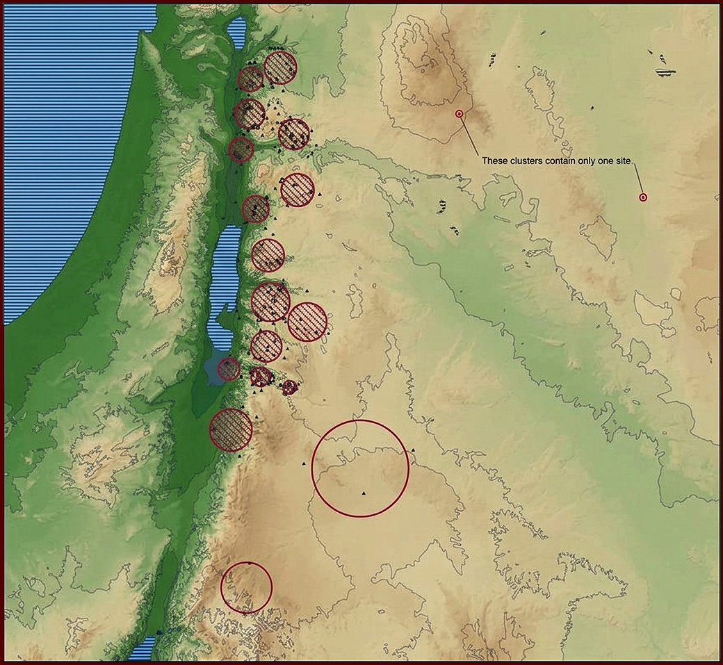
Viable clusters are hatched.
The Monte Carlo Rank-size results indicated a continuous absence of integrated, multi-tiered regional administrative hierarchies across the Early Bronze Age. Instead of centralized, primate city-states, the data revealed:
- Segmentary, localized settlement systems that lacked high-order political integration.
- Socio-political configurations resembling corporate "house societies" or heterarchies rather than bureaucratic states.
- An urban landscape defined by walled agricultural centers that served as community storage and ritual nodes rather than despotic administrative capitals.
How the paper has been used:
- Charloux et al. use the chapter as a comparative baseline to frame their thesis of "low urbanization" and "slow urbanism" at the site of al-Natah. The authors apply this work to justify classifying the small settlement as urban, support the presence of corporate heterarchies rather than centralized states, and contrast regional timelines of social complexity. Charloux, Guillaume, Shadi Shabo, Bruno Depreux, Sylvain Colin, Kévin Guadagnini, François Guermont, Sabine Dupuy et al. "A Bronze Age town in the Khaybar walled oasis: Debating early urbanization in Northwestern Arabia." PLOS One 19, no. 10 (2024): e0309963.
- In Dolmens in the Levant (Routledge, 2018), Dr. James A. Fraser utilizes the 2007 paper to argue that the construction of massive megalithic monuments did not require a top-down, centralized state-level society. By applying the 2007 data on decentralized corporate heterarchies, Fraser demonstrates that independent agro-pastoral groups possessed sufficient social coordination to build and maintain these structures and links the spatial distribution of dolmens to localized permanent settlements as territorial anchors.
- In their 2016 study, Arıkan, Balossi Restelli, and Masi utilize Savage, Falconer, and Harrison's 2007 paper to demonstrate how varying levels of social organization influence the physical footprint of agropastoral land use. The authors employ this framework as a comparative regional baseline to evaluate decentralized settlement networks without relying strictly on centralized Mesopotamian urban models. Arıkan, Bülent, Francesca Balossi Restelli, and Alessia Masi. "Comparative modeling of Bronze Age land use in the Malatya Plain (Turkey)." Quaternary Science Reviews 136 (2016): 122-133.
Consolidated Citations Index: Savage, Falconer & Harrison (Complete List)
| Reference | Summary of the Work | Why it Cites Them (Context & Argument) |
|---|---|---|
| Arıkan, Bülent 2010 Reorganization and Risk: Environmental Change and Tribal Land Use in Marginal Landscapes of Southern Jordan. Unpublished Ph.D. dissertation, Department of Anthropology, Arizona State University, Tempe. |
Investigates long-term relationships between climate shifts and tribal land-use adaptations in marginal southern Jordanian zones. | To contrast rigid Near Eastern state frameworks with flexible, decentralized tribal land-use adaptations across marginal landscapes. |
| Arıkan, Bülent, Francesca Restelli, and Alessia Balossi Masi 2016 Comparative Modeling of Bronze Age Land Use in the Malatya Plain (Turkey). Quaternary Science Reviews 136:122–133. |
Applies digital simulation tools to evaluate and compare Bronze Age agrarian land-use strategies within Turkey's Malatya Plain. | Uses their macro-regional landscape and settlement data as a methodological baseline for comparing Bronze Age land-use simulation parameters outside the Levant. |
| Ashkenazi, Hai 2016 Southern Levantine Early Bronze Age III: Society, Social Power, and Ideology. Unpublished Ph.D. dissertation, Department of Archaeology and Ancient Near Eastern Cultures, Tel Aviv University, Tel Aviv. |
Examines social power structures, architectural developments, and ideological changes during the Southern Levantine Early Bronze Age III. | To evaluate Early Bronze Age III site-size distributions, assessing localized social hierarchies and non-state power dynamics. |
| Berger, Alice, C. Longford, Raphael Greenberg, and Dorian Q. Fuller 2026 Archaeobotany at Tel Bet Yerah (Khirbet el-Kerak): Aspects of Food Production in Early Urban and Diasporic Early Transcaucasian Communities of the Levant. Environmental Archaeology 31(3):273–289. |
Analyzes plant remains from Tel Bet Yerah to understand food production systems within early urban and migratory Early Transcaucasian communities. | To contextualize Early Transcaucasian crop processing within the shifting, agrarian corporate systems of early urban Levantine networks. |
| Braemer, Frank, Denis Genequand, C. Maridat, Dumond Blanc, P.-M. Dentzer, J.-M. Gazagne, and Pierre Wech 2009 Long-Term Management of Water in the Central Levant: The Hawran Case (Syria). World Archaeology 41(1):36–57. |
Traces the historical evolution and long-term socio-political management of hydraulic infrastructure in the Hawran region of Syria. | To examine long-term hydraulic features and water management, contrasting central Levantine desert systems with standard southern cluster data. |
| Charloux, Guillaume, Shadi Shabo, Bruno Depreux, Sylvain Colin, Kévin Guadagnini, François Guermont, Sabine Dupuy, Mylène Bussy, Noisette Bec Drelon, and Modwene Poulmarc’h 2024 A Bronze Age Town in the Khaybar Walled Oasis: Debating Early Urbanization in Northwestern Arabia. PLoS ONE 19(10):e0309963. |
Documents archaeological excavations at a fortified Bronze Age town in the Khaybar Oasis, exploring early urbanism in Arabia. | To contrast the distinct, fortified, walled oasis layouts found in Northwestern Arabia against standard Levantine EBA urban definitions. |
| Collins, Steven, Carroll M. Kobs, and Michael C. Luddeni 2015 The Tall al-Hammam Excavations, Volume 1: An Introduction to Tall al-Hammam with Seven Seasons (2005–2011) of Ceramics and Eight Seasons (2005–2012) of Artifacts from Tall al-Hammam. Eisenbrauns, University Park, Pennsylvania. |
Presents the comprehensive excavation reports, ceramic typologies, and artifact records from the initial seven seasons at Tall al-Hammam. | To anchor spatial attributes and regional site-hierarchy layers surrounding Tall al-Hammam within greater Jordan Valley databases. |
| Danielson, Andrew Joel 2020 Edom in Judah: An Archaeological Investigation of Identity, Interaction, and Social Entanglement in the Negev During the Late Iron Age (8th–6th Centuries BCE). Unpublished Ph.D. dissertation, Department of Near Eastern Languages and Cultures, University of California, Los Angeles. |
Explores identity, cultural entanglement, and socio-political interactions between Edom and Judah in the Late Iron Age Negev. | To track long-term regional population patterns in the Negev, tracing the deep prehistoric layout underneath later Iron Age Edomite systems. |
| De Miroschedji, Pierre 2014 The Southern Levant (Cisjordan) During the Early Bronze Age. In The Oxford Handbook of the Archaeology of the Levant: c. 8000–332 BCE, edited by Ann E. Killebrew and Margreet Steiner, pp. 307–329. Oxford University Press, Oxford. |
Synthesizes settlement data to track the historical trajectory, architecture, and socio-political development of urbanization in the Southern Levant (Cisjordan). | To explicitly challenge their decentralized paradigm, defending a true 'pristine city-state' urban framework for the Southern Levant. |
| De Miroschedji, Pierre 2018 The Urbanization of the Southern Levant in Its Near Eastern Setting. Origini: Preistoria e Protostoria delle Civiltà 42:109–144. |
Analyzes the evolutionary paths of early complex societies across the southern Levant relative to surrounding Near Eastern networks. | Deconstructs their core database parameters to debate if regional towns show proper systemic hierarchy levels matching pristine state standards. |
| El Safadi, Crystal 2013 The Beqa'a Valley During the Early Bronze Age: A GIS Approach to Settlement Patterns. Unpublished Master's thesis, Department of Archaeology, University of Southampton, UK. |
Employs Geographic Information Systems (GIS) to analyze spatial settlement distributions and trajectories in the Beqa'a Valley. | Utilizes their regional GIS site clustering formulas to build a localized predictive spatial framework for the Beqa'a Valley. |
| Falconer, Steven E., and Patricia L. Fall 2022 Sacred Spaces and Liminal Behavior in Levantine Temples in Antis. Journal of Ancient Near Eastern History 9(2):259–284. |
Investigates the ritual roles, architectural evolution, and social significance of public 'temples in antis' across the Bronze Age Levant. | Self-citation to reinforce how non-state rural dynamics, community cohesion, and corporate ritual behaviors intersect at public temples. |
| Fall, Patricia L., Elizabeth Ridder, Suzanne E. Pilaar Falconer, and Steven E. Falconer 2023 Bayesian Modeling of a Peripheral Middle Bronze Age Settlement at Zahrat adh-Dhra ‘1, Jordan. Radiocarbon 65(5):1022–1037. |
Applies Bayesian radiocarbon modeling to establish the absolute chronological phases of the Middle Bronze Age site Zahrat adh-Dhra ‘1. | To frame chronological data mapping out peripheral, localized agropastoral survival at Zahrat adh-Dhra ‘1 away from central urban zones. |
| Fraser, James A. 2016 The Visible Dead: Dolmens and the Landscape in Early Bronze Age Jordan. BAF-Online: Proceedings of the Berner Altorientalisches Forum 1:45–61. |
Examines the landscape distribution, spatial visibility, and ritual contexts of megalithic dolmen tomb features throughout early Jordan. | To conceptualize how landscape-prominent dolmen fields functioned alongside ephemeral, seasonal, and semi-sedentary Early Bronze I communities. |
| Fraser, James A. 2018 Dolmens in the Levant. Routledge, London. |
Presents a macro-regional landscape synthesis of Levantine dolmens, analyzing social corporate memory and territorial markers. | To frame how non-hierarchical pastoral networks and mobile corporate groups consolidated identity markers without central state systems. |
| Fraser, James A., and Kathleen Nicoll 2025 A Settlement-Geology Model for Dolmen Distribution in the Levant: Revisiting the ‘Great Dolmen-Field’ on the Irbid Plateau. Levant 57(2):172–195. |
Combines geomorphology and spatial analysis to create a settlement-geology model for dolmen distribution fields on the Irbid Plateau. | To connect geological landscape metrics and dolmen distribution patterns directly to established demographic maps of the Irbid Plateau. |
| Frumin, Suembikya, Yoel Melamed, Aren M. Maeir, Haskel J. Greenfield, and Ehud Weiss 2021 Agricultural Subsistence, Land Use and Long-Distance Mobility Within the Early Bronze Age Southern Levant: Archaeobotanical Evidence from the Urban Site of Tell eṣ-Ṣâfī/Gath. Journal of Archaeological Science: Reports 37:102873. |
Presents macrobotanical data from Tell eṣ-Ṣâfī/Gath to reconstruct EBA agricultural subsistence practices and territorial mobility. | To integrate fine-grained archaeobotanical profiles from Tell eṣ-Ṣâfī/Gath into macro-regional food production and trade mobility networks. |
| Gaston, Amanda 2018 Human Life in Early Bronze Age I Jericho: A Study of the Fragmented Human Skeletal Remains from Tomb A61. Unpublished Master's thesis, Department of Anthropology, North Carolina State University, Raleigh. |
Performs a bioarchaeological analysis on fragmented human skeletal remains from Tomb A61 to assess health in Early Bronze I Jericho. | To evaluate human skeletal health profiles and urban mortality metrics within the broader regional population models estimated for EB I Jericho. |
| Gayubas, Augusto, and Perla S. Rodríguez (editors) 2019 Poder y Cultura en el Antiguo Egipto: Contribuciones a la Reflexión Histórica sobre el Valle del Nilo y sus Periferias. ICSOH-CONICET-UNSa, Salta, Argentina. |
Compiles historical and archaeological studies exploring political authority, state formation, and culture in the Nile Valley and its borders. | To contrast centralized Egyptian dynastic models of power with the decentralized, tribal social landscape models of the contemporary Levant. |
| Gidding, Aaron David 2016 Approaches to Production and Distribution in Anthropological Archaeology: Views from the Early Bronze Age of Jordan and Israel. Unpublished Ph.D. dissertation, Department of Anthropology, University of California, San Diego. |
Analyzes copper and ceramic manufacturing and trade dynamics to track political economy during the Early Bronze Age of Jordan and Israel. | To evaluate resource distribution, specialized workshops, and craft economies within corporate, non-hierarchical socio-political matrices. |
| Harrison, Timothy P. 2016 Beyond the Madaba Plains Project: A Regional Approach to the Archaeology of the Madaba Plains Region. In The Madaba Plains Project: Forty Years of Archaeological Research into Jordan's Past, edited by Douglas R. Clark, Lawrence T. Geraty, Øystein S. LaBianca, and Randall W. Younker, pp. 156–163. Routledge, London. |
Reviews the history, methodology, and regional archaeological contributions of the Madaba Plains Project across central Jordan. | Self-citation details regional survey strategies utilized by the Madaba Plains Project to reconstruct interactive town-country networks. |
| Hruby, Karolina, Marzena Cendrowska, Rivka Chasan, Iris Groman-Yaroslavski, and Danny Rosenberg 2021 The Function of the South-Levantine Late Chalcolithic and Early Bronze Age Basalt Vessels Bearing Circumferential Depressions: Insights from Use-Wear Analyses. PLoS ONE 16(6):e0252535. |
Uses microscopic use-wear analysis to determine the tasks and functions of Chalcolithic and EBA basalt vessels with depressions. | To cross-reference the domestic, decentralized deployment of ground stone technologies with broader EBA household economic models. |
| Iserlis, Mark, Yael Rotem, and Uri Davidovich 2023 Regionalism, Social Boundaries and Cultural Interaction in the Levantine Early Bronze Age. Levant 55(1):1–5. |
Introduces a collection of papers focused on assessing material regionalism, social boundaries, and interaction in the Early Bronze Age. | To trace shifting regionalism, material culture boundaries, and social frontiers across the early urbanizing Southern Levant. |
| Kampmann, Jürgen, and Christoph Schwöbel (editors) 2019 Die Stadt: Interkulturelle theologische Zugänge. Vandenhoeck & Ruprecht, Göttingen. |
Presents an interdisciplinary volume exploring theological, historical, and sociological perspectives on the evolution of cities. | Cited in introductory chapters reviewing historical deep-time urban origins to establish the non-state layouts of early human clusters. |
| Kobs, Carroll M. 2013 Tall El-Hammam Season Eight, 2013: Excavation, Survey, Interpretations and Insights. Trinity Southwest University Press, Albuquerque, New Mexico. |
Details the field excavations, survey methodologies, and preliminary stratigraphic interpretations from the eighth season at Tall el-Hammam. | To cross-examine regional settlement density and demographic shifts surrounding the monumental architectural phases of Tall el-Hammam. |
| Kołodziejczyk, Piotr, Marek Nowak, Jacek Karmowski, Marcin Czarnowicz, Michał Wasilewski, Agnieszka Brzeska-Zastawna, Justyna Zakrzeńska, and Barbara Witkowska 2024 On the Edge of Prehistory: Preliminary Results of Excavations at Three Chalcolithic and Bronze Age Sites in Southern Jordan. Polish Archaeology in the Mediterranean 32:411–435. |
Outlines the preliminary architectural and artifactual discoveries from excavations at three distinct Chalcolithic and Bronze Age sites in Jordan. | To frame newly exposed Chalcolithic and Bronze Age occupational layers in Southern Jordan against regional demographic cluster maps. |
| Manclossi, Francesca, and Steven A. Rosen 2021 Flint Trade in the Protohistoric Levant: The Complexities and Implications of Tabular Scraper Exchange in the Levantine Protohistoric Periods. In Stone Tools in the Ancient Near East and Egypt, edited by Francesca Manclossi, Steven A. Rosen, and Yannick Marot, pp. 245–262. Routledge, London. |
Tracks the economic complexities, long-distance trade routes, and social implications of lithic tabular scraper exchange in the protohistoric Levant. | To demonstrate how long-distance exchange of specialized tabular scrapers operated through tribal networks without elite command. |
| Nicolle, Christophe 2023 Beyond Urbanization, Regional Settlement Pattern in South-Eastern Levant During the Early Bronze Age. Levant 55(1):26–45. |
Re-evaluates spatial settlement distribution patterns in the south-eastern Levant to propose alternative definitions of EBA urbanization. | Explicitly critiques their decentralized spatial models by mapping settlement clusters to propose alternative pathways to urbanization. |
| Nicolle, Christophe, and Frank Braemer 2012 Settlement Networks in the Southern Levant in the Mid 4th Millennium BC: Sites with Double-Apsed Houses in the Leja Area of Southern Syria During the EBA IA. Levant 44(1):1–16. |
Maps EBA IA regional networks characterized by distinctive double-apsed domestic houses in the Leja volcanic landscape of southern Syria. | To contrast the architectural networks of double-apsed houses in the Syrian Leja with contemporary settlement configurations in the southern Levant. |
| Nigro, Lorenzo 2009 Khirbat al-Batrawy: A Case Study of Third Millennium BC Early Urbanism in North-Central Jordan. Vicino Oriente 15:27–45. |
Presents initial architectural summaries of defensive infrastructure at third millennium BC Khirbat al-Batrawy to trace early urban features. | To present an explicit structural counter-example highlighting centralized civic planning that resists the authors' non-state decentralized argument. |
| Nigro, Lorenzo 2013 Urban Origins in the Upper Wādī az-Zarqā’, Jordan: The City of Khirbat al-Batrāwī in the Third Millennium BC. Studies on the History and Archaeology of Jordan XI: Changes and Challenges, pp. 445–462. Department of Antiquities of Jordan, Amman. |
Traces deep urban trajectories across the upper Wadi az-Zarqa basin, documenting settlement nucleation at Khirbat al-Batrawy. | Evaluates regional cluster sizes, arguing that Zarqa systems show clear primary hierarchy nodes inconsistent with fluid tribal models. |
| Nigro, Lorenzo 2016 Khirbat al-Batrawi 2010–2013: The City Defenses and the Palace of Copper Axes. Studies on the History and Archaeology of Jordan XII: Transparent Borders 12:135–154. |
Reports on systemic defensive expansions and unique metallurgic hoards unearthed in the Palace of Copper Axes at Batrawy. | Utilizes elite storage networks and weapon production data to challenge the premise that southern EBA sites lacked clear administrative palaces. |
| Nigro, Lorenzo 2021 The End of the Early Bronze Age in the Southern Levant. In Crisis to Collapse: The Archaeology of Social Breakdown, edited by Jan Driessen, pp. 149–172. Presses universitaires de Louvain, Louvain-la-Neuve. |
Analyzes socio-economic stress lines, localized systemic fragmentation dynamics, and abandonment traits marking the close of the Levantine EBA. | To contextualize how regional demographic hubs decentralized during climate events, mapping baseline population distributions before collapse. |
| Nigro, Lorenzo, Daria Montanari, Francesco Mura, Jehad Yasine, and Teresa Rinaldi 2018 A Hoard of Nilotic Nacreous Shells from Egypt to Jericho (Early Bronze II, 3000–2800 BCE): Their Finding, Content and Historical Archaeological Implications. Palestine Exploration Quarterly 150(2):110–125. |
Analyzes an Early Bronze II hoard of exotic Nilotic nacreous shells found at Jericho, discussing its economic and trade implications. | To contextualize a rare hoard of Nilotic nacreous shells within established overland and maritime trade paths operating across the EBA Levant. |
| Palmisano, Alessio, Jessie Woodbridge, C. Neil Roberts, Andrew Bevan, Ralph Fyfe, Stephen Shennan, and Rachid Cheddadi 2019 Holocene Landscape Dynamics and Long-Term Population Trends in the Levant. The Holocene 29(5):708–727. |
Combines radiocarbon dates and archaeological survey metadata to model Holocene population trends alongside climate fluctuations in the Levant. | Correlates macro-regional demographic databases directly against long-term Holocene climate fluctuations and population proxy datasets. |
| Park, Seounggyu, Ruth Conrad, Jens Kamlah, Jürgen Moltmann, Reinhold Rieger, Michael Welker, Hans Norbert Janowski, Hyun-Jong Choi, and Ekkehard Starke 2019 Die Stadt: Interkulturelle theologische Zugänge. In Die Stadt: Interkulturelle theologische Zugänge, edited by Jürgen Kampmann and Christoph Schwöbel, pp. 13–38. Vandenhoeck & Ruprecht, Göttingen. |
Provides a text chapter analyzing the cultural and cross-cultural structural concepts that defined urban layout choices in antiquity. | To ground the deep history of corporate ancient Near Eastern communities prior to the development of later historical, classical civic models. |
| Richard, Suzanne 2014 The Southern Levant (Transjordan) During the Early Bronze Age. In The Oxford Handbook of the Archaeology of the Levant: c. 8000–332 BCE, edited by Ann E. Killebrew and Margreet Steiner, pp. 330–354. Oxford University Press, Oxford. |
Synthesizes settlement dynamics, pastoral interaction zones, and urban-rural traits characterizing Early Bronze Transjordan. | To cross-examine site classification frameworks and regional cluster mapping patterns across the eastern side of the Jordan Rift. |
| Richard, Suzanne 2016 On the Periphery of the Madaba Plains Project: Celebrating Core Accomplishments in the Field of Archaeology. In The Madaba Plains Project: Forty Years of Archaeological Research into Jordan's Past, edited by Douglas R. Clark, Lawrence T. Geraty, Øystein S. LaBianca, and Randall W. Younker, pp. 79–93. Routledge, London. |
Evaluates core survey and field paradigm advancements driven by micro-regional exploration projects in central Jordan. | Balances the macro-regional GIS site categorization frameworks against targeted, site-specific physical field data patterns. |
| Richard, Suzanne 2024 Redefining "Collapse" in the Early Bronze Age: New Evidence for Recovery, Resilience, and Societal Transformation at Khirbat Iskandar, Jordan. Journal of Ancient Near Eastern History 11(1):105–141. |
Presents structural field updates from Khirbat Iskandar to trace community recovery, continuity, and system resilience over EBA transitions. | Contrasts the deep occupational resilience strategies of Transjordanian sites against models that favor abrupt regional collapse paradigms. |
| Soto-Berelov, Mariela, Patricia L. Fall, Steven E. Falconer, and Elizabeth Ridder 2015 Modeling Vegetation Dynamics in the Southern Levant Through the Bronze Age. Journal of Archaeological Science 53:94–109. |
Integrates pollen records and simulation modeling to reconstruct vegetation canopy changes and land-use effects throughout the Levantine Bronze Age. | Co-authored study that directly integrates macro-scale population density calculations with simulated vegetation and forest dynamics. |
| Wachtel, Ido, and Uri Davidovich 2021 Qedesh in the Galilee: The Emergence of an Early Bronze Age Levantine Megasite. Journal of Field Archaeology 46(4):260–274. |
Presents regional survey and excavation data identifying the massive layout of Qedesh as a major Early Bronze Age northern megasite. | To debate how the emergence of northern Levantine 'megasites' like Qedesh interacts with existing decentralized regional settlement frameworks. |
| Walzer, Naama 2019 The Intermediate Bronze Age in the Shephelah in Light of Site 248.1. Unpublished Master's thesis, Department of Archaeology and Ancient Near Eastern Cultures, Tel Aviv University, Tel Aviv. |
Examines the spatial distribution, architecture, and ceramic assemblages characterizing the Intermediate Bronze Age transition at Site 248.1 in the Shephelah. | To evaluate site patterns in the Shephelah, charting how EBA regional density fractured during the Intermediate Bronze Age transition. |
| Zhang, Nianhua, and Huiwen Ma 2025 Use GIS Technology to Reveal the Formation and Impact of Early Maritime Trade Routes in the Mediterranean on Cultural Heritage. Journal of Commercial Biotechnology 30(3):701–711. |
Uses spatial GIS mapping techniques to study how ancient Mediterranean maritime shipping networks impacted coastal cultural heritage centers. | Uses their macro-regional Levantine data profiles to populate broad GIS models tracking prehistoric Mediterranean heritage trade corridors. |
Diachronic Modeling of Peripheral Dynamics (2009)
The 2009 publication, "The Bronze Age Political Landscape of the Southern Levant", authored by Steven E. Falconer and Stephen H. Savage, served as the definitive capstone to their two-decade-long research program. Published as a central chapter in the book Polities and Power: Archaeological Perspectives on the Landscapes of Early States (edited by Falconer and Charles Redman; University of Arizona Press), this paper synthesis all of their previous regional datasets, mathematical algorithms, and theoretical models into a macro-regional history of the entire Bronze Age. By running comparative simulation arrays across the EBA, MBA, and LBA, the study provided a quantitative model showing how peripheral regions repeatedly absorb economic and environmental disruptions through the structural reconfiguration of rural settlements rather than top-down state intervention. The 2003 paper looked at the Late Bronze Age (using text + GIS), and the 2007 paper looked at the Early Bronze Age (using JADIS and cis-Jordanian database metrics). The 2009 chapter applied the already existing toolkit—K-means clustering and rank-size graphs—to provide a broad structural overview. The conclusion is environmental and structural: the fragmented topography of the southern Levant (cliffs, valleys, arid zones) simply naturally constrained the economic pooling of resources, meaning the landscape naturally favored smaller, fragmented, fluctuating networks rather than massive, sprawling river-valley empires like Egypt or Mesopotamia.
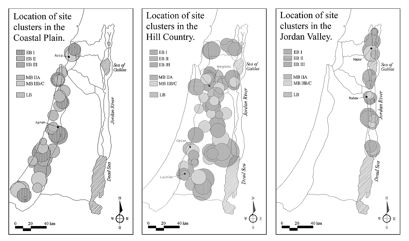
How the paper has been used: Within Levantine archaeology, their 1995 American Antiquity paper and their 2003 BASOR paper remain their most widely cited, mathematically influential breakthroughs. The 2009 chapter is a solid re-application of those models, but it does not carry the weight of an era-defining authority. But the paper has been cited for interesting applications:
- Titolo, Andrea, and Alessio Palmisano. "A tale of two regions: Cyclical human-climate interactions in the South Levant from the Chalcolithic to the Iron Age (6500–2200 BP)." Quaternary Science Reviews 375 (2026): 109777. explicitly cites the 2009 article multiple times. They use the 2009 publication in two specific ways: 1) Contextualizing Regional Population Declines: Titolo and Palmisano use their advanced statistical models (like radiocarbon Summed Probability Distributions) to track macro-demographic shifts over thousands of years. They explicitly cite Falconer and Savage (2009) alongside classic authorities like Broshi, Gophna, and Finkelstein to provide the baseline archaeological consensus for historic population crashes in the region—specifically during the Intermediate Bronze Age (~4500–4000 BP) and the Late Bronze Age (~3400–3150 BP). 2) Factoring in Geographic Asymmetry (Urban vs. Rural): Titolo and Palmisano point out that urbanism, settlement structures, and demographic density were never evenly or symmetrically distributed across the southern Levantine landscape. They cite Falconer and Savage's 2009 work (alongside their 2003 work and Raphael Greenberg) to back up the fact that Middle Bronze Age populations heavily clustered in the Coastal Plain, leaving regions like the Central Hills and the Jordan Rift Valley with fundamentally different, lower-density socio-economic profiles. 3) Reviewing Regional Settlement Models : When discussing the computational methodologies used by past archaeologists to track how these ancient settlements grew or shrank, they list Falconer and Savage's 2009 framework as a key example of utilizing Rank-size analysis to chart macro-regional complexity.
- Ataweel and Squitieri explicitly utilize the 2009 article in Chapter 4 to establish a baseline of localized demographic reality through raw database integration and spatial modeling. The authors leverage this data to demonstrate mathematically that Bronze Age populations in the Southern Levant were heavily concentrated in specific environmental niches, illustrating structurally uneven regional settlement networks prior to imperial expansion. Altaweel, Mark, and Andrea Squitieri. Revolutionizing a world: from small states to universalism in the pre-Islamic Near East. UCL Press, 2018.
- In his paper, Pullen uses his own anisotropic cost-surface modeling (walking times based on steep terrain) to map overlapping territories in Greece. He explicitly references Falconer and Savage's 2009 work (alongside Walter Christaller's Central Place Theory) to ground his comparative discussion on how archaeologists handle contemporaneous, competing regional centers with heavily overlapping territories. Pullen points to Falconer and Savage's Levant models as a key empirical parallel: demonstrating how multiple fortified, independent political hubs can coexist and compete within a tight geographic area without automatically being subordinated to a single, monolithic palace capitalPullen, Daniel J. "The Political Geography of the Late Bronze Age Argolid States and Territories." In Political Geographies of the Bronze Age Aegean: Proceedings of the Joint Workshop of the Belgian School at Athens (EBSA) and the Netherlands Institute at Athens (NIA) May, vol. 28, pp. 75-86. 2021.
Consolidated Citations Index: Falconer & Savage (2009) (Complete List)
| Reference | Publication Summary | Why/How Falconer & Savage 2009 is Used |
|---|---|---|
| Altaweel, Mark, and Andrea Squitieri (2018) Revolutionizing a World: From Small States to Universalism in the Pre-Islamic Near East. UCL Press. |
Traces the long-term historical transition from fragmented Iron Age city-states to sweeping multi-regional Near Eastern empires. | Serves as an empirical baseline for the highly balkanized, non-hierarchical settlement landscape that preceded centralized empires. |
| Steven E. Falconer, Patricia L. Fall and Mariela Soto-Berelov (2009) A Comparison of Vegetation and Settlement Models for the Jordan Rift in the Third and Second Millennia BC. Studies in the History and Archaeology of Jordan 10:745-755. Department of Antiquities of Jordan, Amman. |
Compares macro-regional archaeological site data against regional environmental and botanical degradation models. | Directly deploys the underlying geographic information systems (GIS) settlement dataset developed for the co-authored 2009 volume. |
| Falconer, Steven E., and Patricia L. Fall (2009) Settling the Valley: Agrarian settlement and interaction along the Jordan Rift during the Bronze Age. In E. Kaptijn & L. Petit (Eds.), A Timeless Vale: Archaeological and Related Essays on the Jordan Valley (pp. 113–128). Amsterdam University Press |
Analyzes localized rural Bronze Age agricultural strategies and landscape interactions specifically within the Jordan Rift. | Cross-references concurrent spatial cluster insights regarding demographic density and settlement longevity along the Jordan Valley. |
| Falconer, Steven E., and Patricia L. Fall (2016) "A Radiocarbon Sequence from Tell Abu en-Ni‘aj, Jordan and its Implications for Early Bronze IV Chronology in the Southern Levant." Radiocarbon 58 (3): 615–647. |
Establishes a robust, seed-based absolute AMS radiocarbon chronology for the Early Bronze IV period in the Jordan Valley. | Corroborates long-term micro-regional settlement stability and cluster distributions calculated across the Jordan Rift. |
| Falconer, Steven E., and Patricia L. Fall (2022) Sacred Spaces and Liminal Behavior in Levantine Temples in Antis. Journal of Ancient Near Eastern History, 9(2), 259–284 |
Explores ritual liminality and the socio-political roles of monumental temple architecture across the Levant. | Utilized to contextualize the highly fragmented, fractious, and balkanized macro-political landscape of the Southern Levant. |
| Fall, Patricia L., Steven E. Falconer, and JoAnna Klinge (2015) "Bronze Age Fuel Use and Its Implications for Agrarian Landscapes in the Eastern Mediterranean." Journal of Archaeological Science: Reports 4: 115–130. |
Examines wood charcoal and seed samples to understand structural firewood management strategies in agricultural hinterlands. | Supplies the regional settlement matrix to show why targeted wood collection zones remained stable near major town tell centers. |
| Fall, Patricia L., Steven E. Falconer, and Steven Porson (2019) "Archaeobotanical Inference of Intermittent Settlement and Agriculture at Middle Bronze Age Zahrat adh-Dhraʻ 1, Jordan." Journal of Archaeological Science: Reports 26: 101910. |
Reconstructs short-term agricultural shifts and opportunistic desert farming at the site of Zahrat adh-Dhra' 1 in Jordan. | Contrasts marginal, short-lived desert edge sites with the permanent, highly stable urban clusters modeled in the fertile valleys. |
| Fariss, Matthew Barke (2012) Gallinazo Phase Migration in the Moche Valley, Peru. PhD diss., University of North Carolina at Chapel Hill. |
Tracks population movement, residential architecture, and migration patterns during the Gallinazo phase in South America. | Cites the work as a cross-regional methodological example of how to statistically model non-capital, distributed agrarian networks. |
| Fraser, James A., Jaimie L. Lovell, and Paul Donnelly (2023) Rural Cult in Urban Canaan: An MB/LB ‘Temple’ at el-Khawarij in the Jordan Valley escarpment. In "To Aleppo Gone…": Essays in Honour of Jonathan N. Tubb, edited by Irving L. Finkel, James A. Fraser, and St John Simpson, 43–52. Oxford: Archaeopress Archaeology. |
Presents excavation data from an isolated highland temple to discuss the ritual role of non-urban populations. | Used to explain how isolated, rural highland sanctuaries interacted spatially with the cluster centers down in the rift valleys. |
| Klinge, JoAnna (2013) Assessment of Environmental Change in the Near Eastern Bronze Age [Doctoral dissertation, Arizona State University]. ASU Electronic Dissertations and Theses. |
Synthesizes multiple archaeobotanical datasets to evaluate human adaptation to changing precipitation regimes. | Integrates the spatial settlement matrix to directly correlate structural agricultural strategies with macro-political shifts. |
| Klinge, JoAnna, and Patricia L. Fall (2010) Archaeobotanical inference of Bronze Age land use and land cover in the eastern Mediterranean. Journal of Archaeological Science, 37(10), pp.2622–2629. |
Uses macro-botanical data to reconstruct regional wood collection, crop processing, and human environmental impacts. | Provides the political and demographic framework to correlate localized deforestation with shifting village cluster distributions. |
| de Gruchy, Michelle, Dan Lawrence, and Graham Philip (2021) Climate change and early urbanism in Southwest Asia: A review. WIREs Climate Change, vol. 12, no. 6, 2021, p. e741. |
Reviews non-linear relationships between Holocene climate shifts and Southwest Asian urban adaptations. | Cites the settlement hierarchy matrix to demonstrate localized structural declines prior to the 4.2ka aridification event. |
| Maaranen, Nina (2020) Ties that bind: investigating Hyksos provenance and migration using dental morphology (Doctoral dissertation, Bournemouth University). Bournemouth University Repository. |
Utilizes dental non-metric traits to track the ancestral origins, migration trajectories, and biological kinship of the Hyksos in Egypt. | Establishes the socioeconomic and urbanization backdrop of the Middle Bronze Age Levantine homeland from which populations migrated. |
| Maaranen, N., Stantis, C., Kharobi, A., Schutkowski, H., & Doumet-Serhal, C. (2023) The rise of coastal Middle Bronze Age Levant – A multidisciplinary approach for investigating in Sidon, Lebanon. American Journal of Biological Anthropology, 182(3), 428–439. |
Applies multi-isotopic analysis to human remains from Sidon to reconstruct individual mobility, diet, and maritime connectivity. | Contrasts the highly interconnected maritime population patterns of the coast with the inland political balkanization models. |
| Mazzoni, Stefania (2013) Tell Afis and the Early Middle Bronze Age Transition. In F. Venturi (Ed.), Societies in Transition: Evolutionary Processes in the Northern Levant between the Late Bronze Age II and the Early Iron Age (pp. 21–36). CLUEB. |
Details stratigraphic, architectural, and ceramic developments at Tell Afis to evaluate the EB/MB transition in Northern Syria. | Compares Northern Levantine socio-political developments against the fragmented, polymorphic urban models of the Southern Levant. |
| Mynářová, Jana (2026) The Power of Writing: Cylinder Seals with Cuneiform and Pseudo-Cuneiform Inscriptions in the Southern Levant. Levant 58 (1). |
Examines the distribution, administration, and socio-political semiotics of cuneiform cylinder seals in the Southern Levant. | Contextualizes how administrative markers traveled across the decentralized, politically fragmented landscape identified in the spatial models. |
| Olson, Kyle Gregory (2020) Models of Trade and Polity Formation in Bronze Age Northeastern Iran, ca. 3200–1600 BCE [Doctoral dissertation, University of Pennsylvania]. ProQuest Dissertations and Theses Global. |
Examines exchange systems, socioeconomic complexity, and early polity dynamics in northeastern Iran. | Contrasts Central Asian peer-polity interaction networks with the highly balkanized Levantine town trajectory. |
| Palmisano, A., Woodbridge, J., Roberts, C.N., Bevan, A., Fyfe, R.M., Shennan, S., Cheddadi, R., Greenberg, R., Kaniewski, D., Langgut, D., Leroy, S.A., Litt, T. and Miebach, A. (2019) Holocene landscape dynamics and long-term population trends in the Levant. The Holocene, 29(5), pp.708–727. |
Synthesizes big data (SPD radiocarbon dates, pollen cores) to map broad demographic trends across the entire Levant. | Used to calibrate, ground-truth, and cross-reference localized site counts and sub-regional settlement densities. |
| Pullen, Daniel J. (2021) The Political Geography of the Late Bronze Age Argolid: States and Territories. In Political Geographies of the Bronze Age Aegean, edited by Iro Mathioudaki and Luca Girella, 69–82. Athens: Belgian School at Athens. |
Investigates territorial boundaries, palatial centers, and political organization in Late Bronze Age Greece. | Uses the Levantine Central Place model as a cross-cultural comparative baseline for competitive, non-subordinated town clusters. |
| Soto-Berelov, Mariela, Patricia L. Fall, Steven E. Falconer, and Elizabeth Ridder (2015) Modeling vegetation dynamics in the Southern Levant through the Bronze Age. Journal of Archaeological Science, 53, pp.535–549. |
Integrates landscape simulation software with proxy data to track changing vegetation cover over millennia. | Establishes the human demographic and settlement location map required to seed the spatial land-use simulation equations. |
| Titolo, Andrea & Alessio Palmisano (2026) A tale of two regions: Cyclical human-climate interactions in the South Levant from the Chalcolithic to the Iron Age (6500–2200 BP). Quaternary Science Reviews, Volume 375, 2026, 109777. |
Models long-term socio-ecological resilience and climate-human dynamics in the Southern Levant across multiple eras. | Provides the baseline spatial GIS settlement dataset used to contrast human demographic spikes against proxy climate curves. |
| van Wijngaarden & Driessen (2022) Political Geographies of the Bronze Age Aegean. Leuven: Peeters Publishers. |
Compiles structural spatial, political, and architectural studies of the Bronze Age Aegean landscape. | Framed in the introduction to weigh Central Place Theory adaptations across different Mediterranean sub-regions. |
Conclusions
The 18-year research trajectory detailed here marks a distinct shift in settlement archaeology toward reproducible spatial science by using custom simulation algorithms to address uneven survey recovery rates. Within the highly specialized, niche domain of quantitative settlement archaeology, the publication stream has accumulated a notable grand total of 457 citations. For a technical field focused on regional metrics, this degree of academic engagement reflects a substantial impact that spans three key areas:
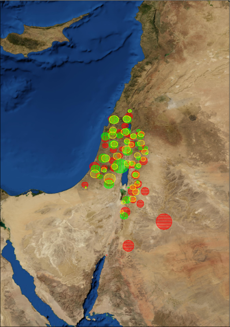
(Red -> EB I, Yellow -> EB II, Green -> EB III).
- Theoretical Re-evaluation: The corrected rank-size models successfully challenged Mesopotamian-centric definitions of civilization, validating localized models of social complexity and rural resilience instead of top-down command economies. The research highlighted the rapid development of urban primacy in southern Mesopotamia's heartland and the more static rural integration of the Diyala hinterland. In contrast, Bronze Age urbanization in the southern Levant describes a mosaic of urban and rural systems following independent trajectories. As a result, greater attention to small sites is required, because the small sites often define the shape of rank-size distributions. The research stream has illuminated modest cases of urbanizatlon in terms of structure, rather than simply of reduced scale, and stresses the need to avoid thinking of such cases as derivatlve.
- Methodological Validation Against Texts: The main objective of the 2003 article was to test the computational and spatial models published in the 1995 and 1997 articles against a known historical framework—polities based on prominent places that featured in the cuneiform correspondence of the Egyptian Amarna Letters. The K-means clustering and rank-size simulations independently matched, to a surprising degree, the set of Theissen polygons Bunimovitz constructed based on the central places described in the texts. The results furnished confidence that the spatial methods employed can discern reliable, reasonable proxies of ancient settlement systems in periods where written documentation is lacking. But beyond the statistical validation of settlement patterns, the results can serve as an alternative window into past settlement systems, even where abundant textual documentation is available. By paying closer attention to actual distributions of settlements within polities, these methods can serve corrective functions vis-a-vis texts that frequently are only concerned with large settlements or central places.
- Cross-Cultural Adoption: The utility of these mathematical and spatial analytical frameworks has extended far beyond Near Eastern archaeology, seeing direct replication by global scholars investigating complex spatial networks in Mesoamerica, South America, the Aegean, and Africa. When regional scholars cite this publication stream, they explicitly use the RankSize program, the Monte Carlo simulation boundaries, and/or the K-means settlement clustering logic to solve spatial problems outside the Near East:
- The Aegean: Scholars like Andrew Bevan (2010) and Todd Whitelaw (2014, 2018) use these exact rank-size convexity frameworks to isolate independent, competing political structures across prehistoric palatial Crete.
Mesoamerica: Urban geographers and Mayan/Aztec specialists (e.g., Carballo & Pluckhahn 2007; Garraty 2006; Golden et al. 2008; Montiel 2010) deploy the 1997 formulas to mathematically quantify shifts in political centralization and measure decentralized market autonomy away from imperial state centers.
- Africa: Archaeological teams mapping early state dynamics in East Africa use the software baselines to track the shifting centralizations of the Aksumite kingdom in Ethiopia (Harrower & D'Andrea 2014; Harrower et al. 2023) and decentralized town growth along the Swahili coast (Fleisher 2010).
- South America: Specialists evaluating prehistoric households and complex networks in the Southern Brazilian highlands (De Souza 2017) and Peru's Moche Valley (Fariss 2012) cite the methodologies to filter out missing smaller settlement tiers from their raw datasets.
Because the universal problem of uneven archaeological discovery—where small sites disappear while massive centers persist—afflicts every regional survey on earth, global scholars routinely rely on this specific 18-year body of work to correct their data curves before claiming a past society was integrated or decentralized. Ultimately, turning this computational architecture into standalone software transformed localized analytical tools into permanent digital infrastructure. Alongside modern GIS, this framework continues to ensure that ancient settlement data can be evaluated as dynamic, statistically verifiable records of human organization.
Chronological Synthesis: The Methodological Evolution
| Year | Milestone / Publication | Technical / Computational Innovation | Theoretical & Disciplinary Contribution |
|---|---|---|---|
| 1991 | Savage (ASU Seminar Paper) | ranksize.bas in Turbo BASIC; 35,000+ Monte Carlo iterations. |
Proved that incomplete survey recovery (<85%) generates artificial primacy; exposed the invalidity of standard KS tables for stepped data. |
| 1992 | Savage (Ruppé Prize Monograph) | RankSize in Turbo Pascal 6.0; linear regression model (OPerf). |
Operationalized simulation on Southern Levant Chalcolithic–Bronze Age survey data; formalized the primo-convex profile. |
| 1995 | Falconer & Savage (American Antiquity) | Regional Rank-size segmentation across geomorphic zones. | Demonstrated that rural village systems maintain structural stability and log-normality despite recurring urban collapse. |
| 1997 | Savage (Journal of Archaeological Science) | Peer-reviewed formalization of Monte Carlo Rank-size simulation. | Established the discipline-wide benchmark for statistically testing departures from log-normality. |
| 2003 | Savage & Falconer (Bulletin of the American Schools of Oriental Research (BASOR)) | Integration of Spatial K-means clustering with within-cluster Rank-size simulation. | Provided independent spatial-archaeological validation of the fragmented, balkanized Canaanite landscape documented in the Amarna Letters. |
| 2007 | Savage, Falconer, & Harrison (in Crossing Jordan) | Macro-regional multi-survey comparative modeling. | Deconstructed the "city-state" paradigm for the Early Bronze Age Levant, proving the existence of decentralized corporate heterarchies. |
| 2009 | Falconer & Savage (in Polities and Power) | Diachronic simulation modeling over a 2,000-year landscape baseline. | Traced the multi-millennial evolutionary cycles of peripheral settlement networks absorbing socio-economic shocks. |
| 2000s+ | RankSize (Visual Basic Edition) | 32-bit graphical desktop application; automated calculation of Zipf’s q; web-based GIS infrastructure. | Transitioned proprietary analytical code into permanent, open-access research infrastructure for international archaeology. |
Major References
Bunimovitz, S. (1995). On the edge of empires: The Late Bronze Age (1500–1200 BCE). In T. E. Levy (Ed.), The archaeology of society in the Holy Land (pp. 320–331). Facts on File.
Falconer, S. E., & Savage, S. H. (1995). Heartlands and peripheries in the southern Levant: Change and continuity in Early Bronze Age rural and urban society. American Antiquity, 60(1), 37–58.
Falconer, S. E., & Savage, S. H. (2009). The Bronze Age political landscape of the southern Levant: Integration, fragmentation, and the spatial structure of local polities. In Polities and Power: Archaeological Perspectives on the Landscapes of Early States, pp. 125-151, edited by S. Falconer and C. Redman. Tucson: University of Arizona Press.
Fisher, C. T., Leisz, S. M., & Outright, M. (2012). Evaluating the settlement scaling and structural primacy of Purepecha state dynamics via airborne LiDAR mapping. Journal of Archaeological Science, 39(12), 3450–3461.
Fulminante, F., et al. (2020). Patterns of Etruscan urbanism: A regional and network-based spatial approach. Frontiers in Digital Humanities, 7, 1–18.
Gophna, R., & Portugali, J. (1987). Settlement and demographic processes in Israel’s coastal plain from the Chalcolithic to Middle Bronze Age. Bulletin of the American Schools of Oriental Research, (269), 11–28.
Preston, D., et al. (2016). Identifying ancient settlement patterns through LiDAR in the Mosquitia region of Honduras. PLOS ONE, 11(8), e0161406.
Safadi, C. (2013). The Beqa'a Valley During the Early Bronze Age: A GIS Approach to Settlement Patterns. Doctoral dissertation, University of Southampton.
Savage, S. H. (1991). A Monte-Carlo Simulation Study of the Rank-Size Rule in Settlement Archaeology. Unpublished manuscript, Department of Anthropology, Arizona State University, Tempe.
Savage, S. H. (1992). A Monte-Carlo Simulation Study of the Rank-Size Rule in Settlement Archaeology: With Application to the Chalcolithic and Bronze Ages of the Southern Levant. Reynold J. Ruppé Prize Monograph, Department of Anthropology, Arizona State University, Tempe.
Savage, S. H. (1997). Assessing departures from log-normality in the Rank-size rule. Journal of Archaeological Science, 24(3), 233–244.
Savage, S. H., & Falconer, S. E. (2003). Spatial and statistical inference of Late Bronze Age polities in the Southern Levant. Bulletin of the American Schools of Oriental Research (BASOR), 16(1), 31–45.
Savage, S. H., Falconer, S. E., & Harrison, T. P. (2007). The Early Bronze Age city-states of the southern Levant: Neither cities nor states. In Crossing Jordan: North American Contributions to the Archaeology of Jordan , pp. 285-297, edited by T. Levy, M. Daviau, R. Younker, and M. Shaer. London: Equinox Publishing Ltd.
Ur, J. A. (2010). Urbanism and Cultural Landscapes in Northeastern Syria: The Tell Hamoukar Survey, 1999–2001. Oriental Institute Publications, Vol. 136. Chicago: The Oriental Institute.