

The Geo-Archaeological Information Applications (GAIA) Lab
|
The combined impacts of population growth, rapid planned and unplanned development, looting and warfare in many parts of the world have placed tremendous pressure on cultural resources and on the government agencies responsible for managing them. Thousands of known historically significant places and archaeological sites are threatened by these forces; untold thousands more await discovery, preservation, and development. It is a daunting task that requires the application of modern methods of data management and retrieval. The task is aptly suited for solutions based on Geographic Information Systems (GIS), database and Web-based technology. The GAIA Lab specializes in developing and deploying integrated GIS standalone and web-based databases for managing cultural resources and other large-scale spatial datasets, using the latest web mapping methods, including Google Maps and Google Earth, powered by AJAX, PHP, KML, JavaScript and MySQL. The lab is affiliated with the Center for Cyber-Archaeology & Sustainability, Qualcomm Institute, University of California, San Diego, and the Capitol Archaeological Institute, George Washington University, Washington, DC. Our Mission
|
 |
|
|
|
The GAIA Lab and Space Archaeology
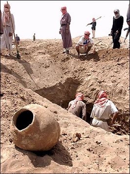
The Slate article from March 31, 2015 -- Satellite Images Don't Lie: What it's like to be an archaeologist watching ISIS and other groups destroy important sites in the Middle East.
 The well-publicized destruction of archaeological sites and museum exhibits by ISIS has garnered worldwide condemnation. Sites like Nineveh, Hatra, and Mosul have been the subject of concerted efforts to destroy the past-and to help goad the United States into a third ground war in northern Iraq and Syria. Recently, we received some good news. It turns out that many of the objects that were destroyed in the Mosul Museum were reproductions; the originals are safely hidden in Baghdad. So perhaps things aren't quite as bad as they appear?
Alas, the situation on the ground is even worse than you think. Destruction of archaeological sites has been an ongoing feature in virtually all the modern wars in the Middle East. Because of the way archaeological sites are used in military operations, there's plenty of blame to spread around. And you've only been told about the famous sites-the ones that are mentioned in the Bible or that have long records of archaeological excavation and publication. But even on these sites, you haven't heard the whole story.
Read the whole story.
![]()
GAIA Lab was Featured in a NASA Article about the Earth Observer 1 Satellite
One of the projects receiving attention here at the lab is the use of hyperspectral satellite imagery for archaeological research. We've requested and received a strip of Hyperion imagery from the Earth Observier 1 (EO-1) satellite, and we're using it to investigate Iron Age copper smelting activity in the Faynan district of Jordan. Hyperion is a sprectrometer flying on the EO-1 satellite, which provides 242 narrow bands in the visible through shortwave infrared spectrum. NASA has recently featured this research in an article on their website, which you can read at this link: http://earthobservatory.nasa.gov/Features/EO1Tenth/printall.php.
GAIA Lab Receives NASA Space Archaeology Grant
As of July 1st, 2010, the GAIA Lab will receive funding from NASA's Space Archaeology program for our project, "Climate Change and Human Impact on Ancient and Modern Settlements: Identification and Condition Assessment of Archaeological Sites in the Northern Levant from Landsat, ASTER and CORONA Imagery." This project will conduct archaeological site prospecting and condition assessment with two methods that utilize Landsat TM, ASTER and CORONA imagery from Lebanon and southwestern Syria. The causes of the Early Bronze Age (ca. 3600-2000 BCE) collapse will be assessed through statistical analysis of settlement pattern data derived from remotely sensed data from the northern Levant, compared to the much better-known settlement systems in the southern Levant. The project will use supervised classification and other image analysis software to find archaeological sites from space and compute precise site location and area dimensions. Site polygon centroids will be used to perform a nearest-neighbor analysis to match remotely-sensed sites to published site names, correct their point coordinates, and record site sizes, using a published inventory whose site locations were recorded only to the nearest kilometer. Collected over a period of about thirty years, satellite imagery can document changes in land cover and development on archaeological sites. Modern site damage will be assessed by comparing the development on sites from CORONA images of the late 1960s-early 1970s to more recent imagery, thus quantifying aspects of land cover change related to development on archaeological sites. You can read about the NASA Space Archaeology program and our successful proposal by pressing the NASA logo above, or the Space Archaeology button on the left.
![]()
NASA Space Archaeology Report
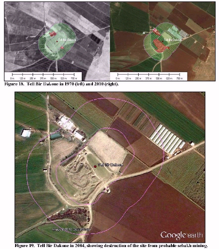 The Final Report for the GAIA Lab's NASA ROSES Space Archaeology grant (09-SAP09-9) can be viewed online by clicking the image shown here, or press the NASA Report button on the button bar. This study has significantly enhanced current methods of archaeological site prospecting through the development and refinement of techniques that make use of Landsat TM, ASTER, Google Earth, and CORONA imagery. The innovative use of ImageJ software, an open-source program developed for analysis of medical tissue thin sections, in archaeological site prospecting is especially exciting. The method, developed by Rempel, is innovative and cost-effective, and can be applied to broad regions outside our immediate study area to significantly increase our knowledge of archaeological site inventories, though it still needs some refinement to eliminate as many false positives as possible.
The impacts of agriculture, warfare and the explosive development of urban areas and their supporting infrastructure have had an extremely adverse effect on archaeological resources in the Middle East. It has been especially severe in Lebanon, which has experienced a civil war and several incursions by the IDF in the forty-year period that spans the production of the satellite imagery to be used by this study. Our methods for discerning site footprints and of assessing the amount of development and that has occurred on archaeological sites have documented this damage in a quantitative manner. This information helps provide a knowledge base of “sites at risk” and thus helps to target specific preservation efforts.
The ultimate archaeological results of this study, which will be developed in Rempel's Ph.D., dissertation, are expected to revolutionize our current understanding of the development and decline of human communities at the end of the Levantine Early Bronze Age, and their resurgence in the subsequent Middle Bronze Age. EBA communities in the southern Levant favored adaptive strategies that preserved flexibility and autonomy over those that emphasized maximum productivity. They never fully relinquished the flexibility needed to adapt to economic downturns and periods of political instability, resisting full integration by maintaining a diverse subsistence base and a high degree of autonomy. South Levantine EBA people and communities established long-term social and environmentally adaptive responses that enabled them to endure repeated cycles of systemic collapse and regeneration. Their patterns of adaptation and hardiness continue to resonate in the modern Middle East (LaBianca 2009). This study will help document the similarity of these south Levantine adaptive patterns to larger regions of the Levant.
![]()
What Happened to the Landsat Images?
All the digital data served by the GAIA Lab web site and Doc Savage's Old World Archaeology web site has been consolidated under the "Digital Resources" button in the navigation bar. This consolidation has made the resources easier to manage, and has enabled them to be shared on our mirror site on the DAAHL Server at UCSD. So if the GAIA Lab web site is down, you can still find the data and programs you're needing.
![]()
Geographic Information Systems (GIS)
GIS is a set of computer methods and techniques that focuses on the creation, management and manipulation of geodatabases. A geodatabase is, simply put, a database that includes a spatial component that can be displayed on a map. Virtually any object that can be located in geographic space can be the object of a geodatabase, whether it is based on a point (such as a highway marker or historic monument), line (such as a river, road, or railroad) or an area (such as a land parcel). The power of GIS lies in its ability to bring attribute data about objects in the real world together with their location in a manner that lets managers and researchers access information in a timely manner, through map-based or attribute-based queries. These data can be used to reinforce planning and modeling decisions, which, in the case of historic preservation and cultural resource management (CRM), allow important places to be identified, preserved, and developed for touristic purposes.
![]()
How Can Cultural Resource Managers Use GIS?
GIS has been developed since the late 1980s into a powerful suite of tools that requires specialist status to adequately manipulate. Many managers and officers charged with the preservation of historic and cultural resources could make extensive use of GIS methods if they were experts in GIS techniques. Unfortunately, most are not, and few have the time to spend developing that expertise. They are too busy trying to preserve the resources. Cultural resource managers and historic preservation specialists need a suite of GIS based tools that are easy to use, and specially tailored to their business practices. They need a way to access data on known sites and monuments that brings everything together at the desktop in a way that supports rapid decision-making and planning. But until now, truly integrated systems of archaeological and historic metadata have not been available.
![]()
Integrated Solutions based on Cutting-Edge Geodatabase Techniques
At the GAIA Lab, GIS based solutions are being developed and deployed to many parts of the world. Our applications deliver archaeological site/historic property and project metadata, assisting ongoing efforts to locate, preserve, and develop cultural resources. Our stand-alone applications use a database design implemented in MS SQL Server, with an MS Access front-end and embedded GIS mapping controls that deliver site and project information against a background of satellite images and topographic maps. The systems link tabular data to an unlimited number of site photographs, to written reports, and to other, more detailed databases developed for specific sites, historic properties and artifact collections. Users can query maps directly, drawing areas of potential impact on screen and retrieving sites and projects that fall within a specified distance of the queried region. Attribute tables can be queried through any combination of fields. Results of either map or attribute queries can be printed or exported to smaller Access-formatted databases for use by fieldworkers. Our web-based solutions employ Google Earth©, Google Maps©, HTML Image Mapping, MySQL, PHP, Javascript and Ajax technologies.